Category:Fort William (Lighthouse)
Jump to navigation
Jump to search
| Object location | | View all coordinates using: OpenStreetMap |
|---|
lighthouse in Ghana .jpg) | |||||
| Upload media | |||||
| Instance of |
| ||||
|---|---|---|---|---|---|
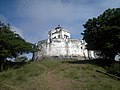
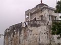
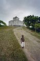
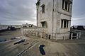
| Location | Cape Coast, Central Region, Ghana | ||||
| Inception |
| ||||
 | |||||
For Fort William at Anomabu, see Category:Fort Anomabu
Main Wikipedia article: Fort William Lighthouse.
|
This is a category about Ghana's material cultural heritage number GH-CP-015
|
Media in category "Fort William (Lighthouse)"
The following 24 files are in this category, out of 24 total.
-
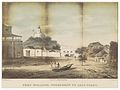 GRAMBERG(1861) p131 FORT WILLIAM, VUURTOREN TE CAPE COAST.jpg 3,106 × 2,323; 3.61 MB
-
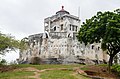
 Cape Coast Fort William Lighthouse.jpg 3,872 × 2,592; 2.13 MB
-
 COLLECTIE TROPENMUSEUM Fort William op Lighthouse Hill TMnr 60024064.jpg 700 × 487; 201 KB
-
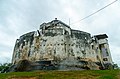
 Fort William (1 of 9).jpg 4,928 × 2,094; 567 KB
-
 Fort William (2 of 9).jpg 4,424 × 2,674; 1.44 MB
-
 Fort William (3 of 9).jpg 4,928 × 3,264; 1.96 MB
-
 Fort William (4 of 9).jpg 4,928 × 2,934; 1.5 MB
-
 Fort William (5 of 9).jpg 4,928 × 3,264; 2 MB
-
 Fort William (6 of 9).jpg 4,928 × 3,264; 1.93 MB
-
 Fort William (7 of 9).jpg 4,928 × 3,264; 2.43 MB
-
 Fort William (8 of 9).jpg 4,928 × 3,264; 1.56 MB
-
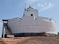 Fort William (Lighthouse).jpg 4,000 × 3,000; 3.65 MB
-
 Fort William 1.JPG 5,184 × 3,456; 2.32 MB
-
 Fort William 2.JPG 5,184 × 3,456; 2.71 MB
-
 Fort William.jpg 4,000 × 3,000; 1.18 MB
-
 FORT WILLIAM3.jpg 896 × 672; 154 KB
-
 FORT WILLIAM4.jpg 672 × 896; 157 KB
-
 Overzicht - Cape Coast - 20373071 - RCE.jpg 783 × 1,200; 211 KB
-
 Overzicht met kanonnen en uitkijktoren - Cape Coast - 20373075 - RCE.jpg 1,200 × 783; 149 KB
-
 Overzicht met uitkijktoren - Cape Coast - 20373074 - RCE.jpg 1,200 × 785; 167 KB
-
 Overzicht uitkijktoren - Cape Coast - 20373072 - RCE.jpg 783 × 1,200; 159 KB
-
 Stadsgezicht met kerk vanaf fort - Cape Coast - 20373076 - RCE.jpg 783 × 1,200; 155 KB
-
 Stadsgezicht vanaf fort - Cape Coast - 20373073 - RCE.jpg 1,200 × 783; 145 KB
-
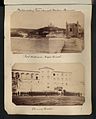 The National Archives UK - CO 1069-30-36.jpg 736 × 916; 127 KB
_p131_FORT_WILLIAM,_VUURTOREN_TE_CAPE_COAST.jpg)


.jpg)
.jpg)
.jpg)
.jpg)
.jpg)
.jpg)
.jpg)
.jpg)


