Category:Floods in London
Jump to navigation
Jump to search
Subcategories
This category has the following 2 subcategories, out of 2 total.
S
Media in category "Floods in London"
The following 48 files are in this category, out of 48 total.
-
 1 Knightsbridge , Walton Street , London.jpg 2,125 × 2,952; 3.2 MB
-
 Beckenham2.jpg 900 × 571; 371 KB
-
 Bench - Oak Hill Park - geograph.org.uk - 1730175.jpg 1,172 × 1,465; 743 KB
-
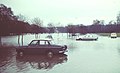
 Bromley Road - 1968 Flood - geograph.org.uk - 283574.jpg 640 × 527; 141 KB
-
 Canoes in Chiswick Mall.jpg 3,456 × 4,608; 2.74 MB
-
 Chiswick Mall - geograph.org.uk - 7202.jpg 640 × 480; 102 KB
-
 Chiswick Mall flooded at high tide - geograph.org.uk - 1327767.jpg 640 × 480; 96 KB
-
 Corporation Island flood.JPG 3,264 × 2,448; 2.01 MB
-
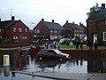
 Crayford High Street flood 1968 - geograph.org.uk - 2723527.jpg 3,888 × 2,588; 1.5 MB
-
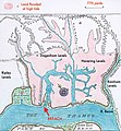 Dagenham Breach map.jpg 2,400 × 2,596; 1.4 MB
-
 Dierenverzorging, SFA022805379.jpg 3,540 × 2,584; 1.53 MB
-
 Drowning bike.JPG 3,264 × 2,448; 1.44 MB
-
 Evening Standard headline news Thames floods 2007.jpg 1,024 × 576; 251 KB
-
 Field End Road - geograph.org.uk - 495440.jpg 640 × 426; 68 KB
-
 Flood chaos on Colney Hatch Lane - geograph.org.uk - 965393.jpg 640 × 480; 53 KB
-
-
 Flooded Tooting Broadway.jpg 960 × 1,280; 199 KB
-
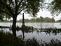 Flooding at Old Deer Park - geograph.org.uk - 3185929.jpg 4,000 × 3,000; 4.29 MB
-
 Flooding at Old Deer Park - geograph.org.uk - 3187605.jpg 4,000 × 3,000; 4.32 MB
-
 Flooding at Old Deer Park Recreation Ground - geograph.org.uk - 3187613.jpg 4,000 × 3,000; 4.37 MB
-
 Flooding at Old Deer Park Recreation Ground - geograph.org.uk - 3187615.jpg 4,000 × 3,000; 4.3 MB
-
 Flooding on the Southern Railway (CJ Allen, Steel Highway, 1928).jpg 846 × 484; 78 KB
-
 GT Flash flood at Mud Bench.jpg 3,456 × 4,608; 5.96 MB
-
 High Tide at Ham - geograph.org.uk - 2983644.jpg 2,042 × 1,234; 767 KB
-
 July 2021 London floods - North Circular at South Woodford.jpg 4,032 × 3,024; 4.12 MB
-
 Lambeth flood refugees.png 767 × 977; 832 KB
-
 Lewisham - 1968 Floods - geograph.org.uk - 283691.jpg 640 × 446; 114 KB
-
 London General VE1 on Route 85, The Thames (Putney) (14683744323).jpg 3,264 × 2,448; 2.57 MB
-
 London HoP JBU 01.JPG 5,235 × 3,491; 5.47 MB
-
 London Victoria Station flooded.jpg 1,600 × 1,200; 240 KB
-
 Morden Road railway station (1981) 01.JPG 1,840 × 1,232; 752 KB
-
 Morden Road railway station (1981) 02.JPG 1,840 × 1,232; 813 KB
-
 Morden Road railway station (1981) 03.JPG 1,840 × 1,232; 741 KB
-
 More Flood Chaos at Colney Hatch - geograph.org.uk - 965400.jpg 640 × 480; 60 KB
-
 Oak Hill Park flooding Jan 2016.JPG 4,000 × 3,000; 4.07 MB
-
 Old Deer Park Recreation Ground from the towpath - geograph.org.uk - 3187609.jpg 4,000 × 3,000; 4.19 MB
-
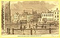
 Opening of the Southern Embankment of the Thames, at Lambeth - ILN 1869.jpg 1,474 × 1,050; 983 KB
-
 Possibly no rugby any time soon^ - geograph.org.uk - 3851849.jpg 640 × 480; 59 KB
-
 Richmond flood.JPG 3,191 × 2,393; 2.59 MB
-
 River Thames High Tide onto Bus (14683777503).jpg 3,264 × 2,448; 2.78 MB
-
 Sparrows Den - Game Off - geograph.org.uk - 3554060.jpg 1,782 × 1,206; 181 KB
-
 State of the Thames at Greenwich during the High Tide of Thursday Week - ILN 1860.jpg 1,827 × 1,092; 424 KB
-
 Stranded car by George Crescent - geograph.org.uk - 965397.jpg 640 × 480; 71 KB
-
 Thames flooding at Chiswick Lane South, London W4 (2).jpg 1,280 × 960; 487 KB
-
 Thames flooding at Chiswick Lane South, London W4.jpg 1,280 × 960; 445 KB
-
 Thames overflow, Lambeth.jpg 2,500 × 1,589; 831 KB
-
 The High Tide at Lambeth on Wednesday Week - ILN 1860.jpg 1,470 × 886; 1.04 MB
-
 TheWash-Ilford (24056362158).png 1,250 × 1,250; 3.03 MB


.jpg)


_(14683744323).jpg)


_01.JPG)
_02.JPG)
_03.JPG)


.jpg)


.jpg)


.png)