Category:Floodplains
Jump to navigation
Jump to search
area of land adjacent to a stream or river which stretches from the banks of its channel to the base of the enclosing valley walls, and which experiences flooding during periods of high discharge  | |||||
| Upload media | |||||
| Pronunciation audio | |||||
|---|---|---|---|---|---|
| Subclass of | |||||
| Different from | |||||
| |||||
Deutsch: Aue, Flussaue oder Flussniederung, auch Überschwemmungsebene. Hingegen versteht man unter Überschwemmungsgebiet normalerweise ein akut unter Wasser stehendes Gebiet.
English: Floodplain or flood plain
Español: Terreno inundable
Nederlands: Riviervlakten
Subcategories
This category has the following 14 subcategories, out of 14 total.
Media in category "Floodplains"
The following 95 files are in this category, out of 95 total.
-
 A series of paired river terraces plainsvg.svg 1,904 × 2,165; 75 KB
-
 A series of paired river terraces.jpg 2,456 × 2,344; 639 KB
-
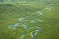 Aerial photography of river in green hills.jpg 2,100 × 1,397; 387 KB
-
 Angzam tmo 2010117 lrg 01.jpg 6,144 × 6,372; 7.52 MB
-
 Angzam tmo 2010117 lrg 02.jpg 720 × 480; 235 KB
-
 Avon valley floodplain north of Downton - geograph.org.uk - 160422.jpg 640 × 480; 133 KB
-
Breggia (Hochwasser)-2.webm 3.9 s, 1,080 × 1,920; 9.52 MB
-
Breggia (Hochwasser).webm 8.1 s, 1,920 × 1,080; 31.86 MB
-

-
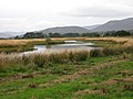
 Conon floodplain - geograph.org.uk - 227803.jpg 640 × 350; 56 KB
-
 Cyclone Nargis flooding before-and-after.jpg 540 × 712; 137 KB
-
 Dallas Texas skyline overlooking the Trinity River in spring 2024 Full Resolution.jpg 24,439 × 6,087; 75.28 MB
-
 Earn Floodplain - geograph.org.uk - 159198.jpg 640 × 480; 73 KB
-
 Eucalyptus coolabah on floodplain, Rockhampton, Queensland.jpg 1,642 × 2,395; 2.04 MB
-
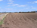
 Farmland on Floodplain - geograph.org.uk - 136771.jpg 640 × 426; 58 KB
-
 Fields from the Cobb Bridge at Paducah.jpg 2,816 × 1,584; 920 KB
-
 Fisheries Habitat Projects in the Pacific Region (4931597403).jpg 720 × 540; 542 KB
-
 Fiumara Precariti.jpg 2,816 × 2,112; 692 KB
-
 Flickr - Nicholas T - Field of View.jpg 2,816 × 2,112; 3.73 MB
-
 Flickr - Nicholas T - Floodplain (1).jpg 2,816 × 2,112; 6.23 MB
-
 Flickr - Nicholas T - Floodplain.jpg 2,816 × 1,695; 4.63 MB
-
 Flood Plain of the River Seaton - geograph.org.uk - 171769.jpg 640 × 427; 96 KB
-
 Floodplain Auenlandschaft Sense Sodbach 1.jpg 4,224 × 3,168; 5.26 MB
-
 Floodplain Auenlandschaft Sense Sodbach 23.jpg 4,224 × 3,168; 5.25 MB
-
 Floodplain cs.svg 596 × 391; 186 KB
-
 Floodplain fields - geograph.org.uk - 86500.jpg 640 × 480; 57 KB
-
 Floodplain of R Spey - geograph.org.uk - 60766.jpg 640 × 479; 123 KB
-
 Floodplain of River Dee. - geograph.org.uk - 15427.jpg 640 × 480; 86 KB
-
 Floodplain of the River Wear - geograph.org.uk - 148386.jpg 640 × 480; 80 KB
-

-
 Floodplain, small-scale 2.jpg 4,032 × 3,024; 4.51 MB
-
 Floodplain, small-scale 3.jpg 4,032 × 3,024; 5.68 MB
-
 Floodplain, small-scale.jpg 4,032 × 3,024; 5.88 MB
-
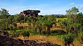 Floodplains at Ubirr, Kakadu National Park.jpg 4,608 × 2,592; 1.92 MB
-
 Gorges du rhummel 00const01 (2).jpg 1,536 × 2,048; 1.01 MB
-
 Herbstein Talauen bei Herbstein SCI 555520799 Winter Floodplain N.png 2,604 × 1,738; 7.31 MB
-
 Hoanib Floodplain.jpg 1,024 × 682; 292 KB
-
 Hunzigenau Rubigen.jpg 4,224 × 3,168; 5.76 MB
-
 ICHoiAnMySon10.jpg 2,594 × 1,675; 1.33 MB
-
 ICPhuYen02.jpg 3,280 × 2,170; 1.5 MB
-
 ICPhuYen03.jpg 3,280 × 2,170; 2.28 MB
-
 Indeauen1.jpg 1,317 × 859; 92 KB
-
 Johnson grass covering floodplain sorghum halepense.jpg 2,900 × 2,175; 564 KB
-
 Junction of the Yukon and Koyukuk Rivers, Alaska.jpg 3,177 × 2,706; 5.96 MB
-
 Kolongal Jaaw (Jaaw floodplain).jpg 3,072 × 2,304; 1.45 MB
-
 Langel Aue im Winter-CN.jpg 2,900 × 2,008; 8.14 MB
-
 Lauf der Stekendammsau.jpg 3,648 × 2,736; 2.41 MB
-
 Looking across the floodplain of the River Balvag.jpg 640 × 480; 87 KB
-
 Makuleke1.JPG 2,048 × 1,536; 563 KB
-

-
 Meander-Cuckmere River-MT.JPG 2,006 × 1,307; 937 KB
-
 Muara sungai Citarum.jpg 2,924 × 1,908; 2.93 MB
-
 Nant-y-Gwryd's Floodplain - geograph.org.uk - 218567.jpg 640 × 480; 74 KB
-
 Nivka River and Bilychee-Wood in Kyiv.jpg 22,441 × 4,597; 39.39 MB
-
 North Limb Como Anticline.jpg 3,701 × 2,512; 7.12 MB
-
 Ouse floodplain - geograph.org.uk - 123520.jpg 640 × 479; 126 KB
-
 Overbank-Price River.jpg 17,429 × 3,628; 51.84 MB
-
 Paraná River Floodplain, Northern Argentina.jpg 4,288 × 2,850; 3.8 MB
-
 Paraná River Floodplain.jpg 720 × 480; 179 KB
-

-
 PetalumaRiverFloodplain.jpg 4,000 × 2,250; 2.59 MB
-
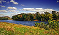
 Pine Creek Valley (14599306192).jpg 5,184 × 3,456; 12.61 MB
-
 Planina Postojna Slovenia - flooded plain.JPG 2,509 × 1,741; 1.36 MB
-
 Pustopolje-poplavnaravnica.JPG 4,000 × 3,000; 4.59 MB
-
 Queensland State Archives 3288 Coolibah Bundaleer c 1910.png 552 × 720; 353 KB
-
 Receding glacier-en.svg 1,200 × 562; 260 KB
-
 Red cedar floodplain.jpg 250 × 188; 51 KB
-
 RedRiverMeandersArkansas1.jpg 3,055 × 3,580; 5.09 MB
-
 RedRockRiverMontana.jpg 4,036 × 2,423; 1.14 MB
-
 Rio Negro Floodplain, Patagonia, Argentina 2010-01-04 lrg.jpg 1,440 × 960; 833 KB
-
 Rio Negro Floodplain, Patagonia, Argentina 2010-01-04.jpg 720 × 480; 162 KB
-
 RioPastaza.jpg 2,816 × 2,112; 2.84 MB
-
 River Severn flood plain - geograph.org.uk - 574091.jpg 640 × 408; 62 KB
-

-

-
-
 Ruigte in de Bemmelse uiterwaarden.jpg 4,032 × 3,024; 15.75 MB
-
 Stekendammsau.jpg 3,648 × 2,736; 3.72 MB
-
 The Thames floodplain, Shiplake - geograph.org.uk - 510647.jpg 640 × 480; 139 KB
-
 Timia Valley Floor.JPG 1,024 × 768; 494 KB
-
 Traisenau bei Getzersdorf.jpg 4,928 × 3,264; 5.67 MB
-
 Uren Flood plain of Usta River.JPG 1,920 × 2,560; 1.93 MB
-
 Valle di Muggio, after the 2021 floods 01.jpg 4,032 × 3,024; 5.81 MB
-
 Valle di Muggio, after the 2021 floods 09.jpg 4,032 × 3,024; 7.37 MB
-
 Valle di Muggio, after the 2021 floods 10.jpg 16,358 × 3,628; 20.03 MB
-
 Valle di Muggio, after the 2021 floods 11.jpg 4,032 × 3,024; 6.04 MB
-
 Valle di Muggio, after the 2021 floods 12.jpg 3,024 × 4,032; 6.48 MB
-
 Valle di Muggio, after the 2021 floods 13.jpg 3,024 × 4,032; 5.71 MB
-
 Valle di Muggio, after the 2021 floods 14.jpg 16,382 × 3,628; 18.12 MB
-
 Valle di Muggio, after the 2021 floods 15.jpg 4,032 × 3,024; 6.51 MB
-
 Wien Toter Grund.jpg 3,000 × 2,240; 1.78 MB
-
 Zambezi Barotse floodplain.jpg 396 × 700; 61 KB
-
 Природний біоценоз заплавних лук.jpg 1,200 × 900; 349 KB
-
 ივრის ჭალა (G.N. 2009).jpg 3,264 × 2,448; 2.85 MB
-
 მდინარე ლოპოტის ჭალა.jpg 2,592 × 1,456; 921 KB


.jpg)


.jpg)


.jpg)


.jpg)


.jpg)


.jpg)
