Category:Flat River (Michigan)
Jump to navigation
Jump to search
- Mouth (Lowell)
| Object location | | View all coordinates using: OpenStreetMap |
|---|
- Headwaters (approximate location near Six Lakes and the Edmore State Game Area)
| Object location | | View all coordinates using: OpenStreetMap |
|---|
river in Michigan, United States of America  | |||||
| Upload media | |||||
| Instance of | |||||
|---|---|---|---|---|---|
| Location |
| ||||
| Mouth of the watercourse | |||||
| Drainage basin |
| ||||
 | |||||
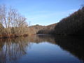
From the English Wikipedia article on the Flat River:
The Flat River is a tributary of the Grand River in western Michigan that runs through Montcalm County, Ionia County, and Kent County, flowing into the Grand at Lowell. Two historic covered bridges cross the river. One, the Fallasburg Bridge, in Vergennes Township, Kent County is in Fallasburg County Park a few miles north of Lowell. The other, Whites Bridge is a few miles to the northeast in adjacent northwest Keene Township, Ionia County, near Smyrna. Both bridges are on small county roads.
Subcategories
This category has the following 2 subcategories, out of 2 total.
F
- Fallasburg Bridge (19 F)
W
- Whites Bridge (9 F)
Media in category "Flat River (Michigan)"
The following 4 files are in this category, out of 4 total.
-
 Fallasburg County Park.jpg 7,188 × 2,008; 4.05 MB
-
 Flat River Map US MI.svg 653 × 1,201; 526 KB
-
 Flatriver.jpg 392 × 250; 25 KB
-
 WhitesBridge FlatRiver Scene DSCN9933.JPG 1,600 × 1,200; 359 KB

