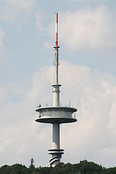
Category:Fernmeldeturm Jakobsberg
Jump to navigation
Jump to search
| Object location | | View all coordinates using: OpenStreetMap |
|---|
tower | |||||
| Upload media | |||||
| Instance of | |||||
|---|---|---|---|---|---|
| Made from material | |||||
| Location | Porta Westfalica, Minden-Lübbecke District, Detmold Government Region, North Rhine-Westphalia, Germany | ||||
| Commissioned by | |||||
| Owned by | |||||
| Height |
| ||||
 | |||||
Media in category "Fernmeldeturm Jakobsberg"
The following 37 files are in this category, out of 37 total.
-
1967-alter-Fernsehturm.jpg 1,601 × 2,401; 664 KB
-
1967-Jakobsberg.jpg 2,402 × 1,601; 900 KB
-
2010-05-21 Minden Weser und Jakobsberg.jpg 2,048 × 1,536; 243 KB
-
2014-04-12 Blick vom Kaiser-Wilhelm-Denkmal 1.JPG 4,000 × 3,000; 4.2 MB
-
2014-04-12 Blick vom Kaiser-Wilhelm-Denkmal 2.JPG 4,000 × 3,000; 2.47 MB
-
32457 Porta Westfalica, Germany - panoramio (25).jpg 4,608 × 3,456; 751 KB
-
Blick auf den Fernsehturm Porta Westfalica.jpg 2,048 × 1,536; 806 KB
-
Blick zum Wesergebirge und zum Jakobsberg mit Fernsehturm.JPG 2,048 × 1,536; 428 KB
-
CME nach porta.jpg 1,280 × 960; 626 KB
-
Fernmeldeturm Jakobsberg 0860.jpg 3,672 × 4,896; 3.83 MB
-
Fernmeldeturm Jakobsberg 0861.jpg 3,672 × 4,896; 923 KB
-
Fernsehturm Jacobsberg.jpg 960 × 1,280; 499 KB
-
Fernsehturm1.jpg 505 × 840; 91 KB
-
FMT Porta Westfalica.JPG 2,848 × 4,272; 2.62 MB
-
Großer Weserbogen Mittlerer See (2).jpg 3,648 × 2,432; 3.31 MB
-
Hausberge-2.jpg 1,602 × 1,078; 1.29 MB
-
Hausberge.jpg 1,274 × 830; 621 KB
-
Jakobsberg von Norden.jpg 989 × 578; 371 KB
-
Kaiser Wilhelm I. - Denkmal in Porta Westfalica.jpg 1,000 × 667; 424 KB
-
Panorama Porta Westfalica.JPG 5,708 × 1,528; 1.28 MB
-
Porta Westfalica 2005 (portaner).jpg 1,024 × 768; 365 KB
-
Porta Westfalica 2005.jpg 2,048 × 1,536; 623 KB
-
Porta Westfalica Fernsehturm (01).JPG 800 × 1,200; 92 KB
-
Porta Westfalica von Norden.jpg 1,264 × 698; 670 KB
-
Porta Westfalica, 2009-Nov (Panorama 03).jpg 10,827 × 1,737; 1.78 MB
-
Porta Westfalica, 2009-Nov (Panorama 04).jpg 9,303 × 1,744; 2.33 MB
-
Porta Westfalica, 2009-Nov 061.jpg 1,600 × 1,200; 632 KB
-
Porta Westfalica, 2009-Nov 062.jpg 1,600 × 1,200; 579 KB
-
Porta Westfalica, 2009-Nov 151.jpg 1,200 × 1,600; 458 KB
-
Porta Westfalica, 2009-Nov 162.jpg 1,600 × 1,200; 374 KB
-
Porta.jpg 3,259 × 1,211; 511 KB
-
PortaWestfalica2.jpg 1,682 × 811; 441 KB
-
River Weser (Minden) South To Porta West Falica (RLH).jpg 1,548 × 1,008; 1.56 MB
-
Todtenhausen Blick auf Porta.jpg 1,360 × 1,024; 314 KB
-
TV tower - panoramio (1).jpg 3,872 × 2,592; 1.96 MB
-
Weserdurchbruch bei Porta Westfalica.jpg 2,816 × 2,112; 1.67 MB
-
Weserwerft minden mit schiff.jpg 2,048 × 1,536; 519 KB
Categories:
- Buildings in Porta Westfalica
- Antenna towers and masts in Kreis Minden-Lübbecke
- Towers in Kreis Minden-Lübbecke
- Concrete towers in North Rhine-Westphalia
- Round towers in Kreis Minden-Lübbecke
- Jakobsberg (Wesergebirge)
- Built in North Rhine-Westphalia in 1978
- 142-meter-tall buildings in Germany
- 100-149-meter-tall buildings in North Rhine-Westphalia


