Category:Fenton Airfield, Northern Territory
Jump to navigation
Jump to search
| Object location | | View all coordinates using: OpenStreetMap |
|---|
world War II airfield  | |||||
| Upload media | |||||
| Instance of | |||||
|---|---|---|---|---|---|
| Location | Northern Territory, AUS | ||||
| Operator | |||||
| Dissolved, abolished or demolished date |
| ||||
 | |||||
Media in category "Fenton Airfield, Northern Territory"
The following 22 files are in this category, out of 22 total.
-
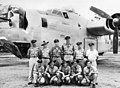
 21 Squadron RAAF Liberator aircrew Fenton NT Mar 1945 AWM NWA0727.jpg 640 × 457; 175 KB
-
 21 Squadron RAAF Liberator aircrew Fenton NT Mar 1945 AWM NWA0728.jpg 640 × 461; 178 KB
-
 21 Squadron RAAF Liberator aircrew Fenton NT Mar 1945 AWM NWA0730.jpg 640 × 471; 213 KB
-
 21 Squadron RAAF Liberator aircrew Fenton NT Mar 1945 AWM NWA0731.jpg 637 × 471; 101 KB
-
 21 Squadron RAAF Liberator aircrew Fenton NT Mar 1945 AWM NWA0732.jpg 640 × 463; 160 KB
-
 24 Squadron RAAF Liberator aircrew Fenton NT AWM NWA0625.jpg 236 × 331; 19 KB
-
 24 Squadron RAAF Liberator aircrew Fenton NT AWM NWA0626.jpg 640 × 469; 185 KB
-
 24 Squadron RAAF Liberator aircrew Fenton NT AWM NWA0628.jpg 336 × 462; 104 KB
-
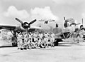
 24 Squadron RAAF Liberator aircrew Fenton NT AWM NWA0629.jpg 640 × 471; 241 KB
-
 24 Squadron RAAF Liberator aircrew Fenton NT AWM NWA0630.jpg 640 × 466; 151 KB
-
 24 Squadron RAAF Liberator aircrew Fenton NT AWM NWA0632.jpg 640 × 470; 223 KB
-
 24 Squadron RAAF Liberator aircrew Fenton NT Jan 1945 AWM NWA0710.jpg 583 × 463; 199 KB
-
 24 Squadron RAAF Liberator aircrew Fenton NT Jan 1945 AWM NWA0711.jpg 640 × 469; 211 KB
-
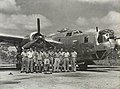
 24 Squadron RAAF Liberator at Fenton NT 1944 AWM NWA0617.jpg 640 × 475; 197 KB
-

-
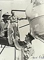
 24 Squadron RAAF Liberator engine maintenance Fenton NT AWM NWA0618.jpg 335 × 463; 104 KB
-
 24 Squadron RAAF Liberator tail guns Fenton NT 1944 AWM NWA0619.jpg 640 × 479; 198 KB
-
 24 Squadron RAAF Liberator tail guns Fenton NT 1944 AWM NWA0624.jpg 338 × 460; 98 KB
-
 82 Wing RAAF B-24s Fenton.jpg 640 × 465; 148 KB
-
 90th BG Liberator Fenton NT 1943 AWM NWA0499.jpg 640 × 478; 200 KB
-
 90th BG Liberator Fenton NT AWM NWA0327.jpg 640 × 470; 157 KB
-


