Category:Farm Gunsteling
Jump to navigation
Jump to search
| Object location | | View all coordinates using: OpenStreetMap |
|---|
Deutsch: Eine Farm in Namibia
English: A farm in Namibia
Media in category "Farm Gunsteling"
The following 15 files are in this category, out of 15 total.
-
 Bones of cattle on a farm in Namibia.jpg 4,883 × 3,239; 5.72 MB
-
 Cessna 206 at airfield on a farm in Namibia.jpg 4,227 × 2,812; 6.77 MB
-
 Cessna 206 at Farm Gunsteling, Namibia.jpg 4,591 × 3,011; 4.95 MB
-
 Devil's thorn flower (Tribulus zeyheri), Kalahari.jpg 3,853 × 2,659; 4.08 MB
-
 Distriktstraße D1001 bei Farm Gunsteling, Namibia (2017).jpg 4,928 × 3,264; 6.76 MB
-
 Farm gate, Namibia.jpg 4,653 × 3,125; 5.56 MB
-
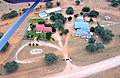
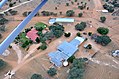 Farm Gunsteling, Namibia (2017).jpg 4,928 × 3,264; 5.28 MB
-
 Farm within Kalahari Desert (Namibia).jpg 4,536 × 2,961; 6.03 MB
-
 Gate of Farm Gunsteling in Namibia (2017).jpg 4,928 × 3,264; 5.51 MB
-
 Melken auf Farm Gunsteling, Namibia (2017).jpg 4,407 × 2,660; 4.35 MB
-
 Private Hangar, Farm in Namibia (2017).jpg 4,928 × 3,264; 4.92 MB
-
 Self-made farm intruder alarm system, Namibia.jpg 4,130 × 3,032; 7.54 MB
-
 Sheep farming in Namibia (2017).jpg 4,249 × 2,581; 4.7 MB
-
 Welcome sign on Farm Gunsteling, Namibia.jpg 4,630 × 3,025; 5.3 MB
-
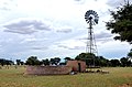 Windmotor mit Bassin in der Kalahari.jpg 4,928 × 3,264; 5.83 MB


,_Kalahari.jpg)
.jpg)

.jpg)
.jpg)
.jpg)
.jpg)
.jpg)

.jpg)

