Category:Fallenkobelweg
Jump to navigation
Jump to search
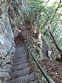
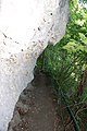
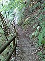
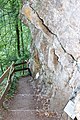
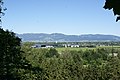
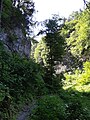
Deutsch: Der Fallenkobelweg (auch: Fallakobelweg) führt von 412 m.ü.A. in der Gemeinde Hohenems über das Gemeindegebiet von Altach nach Götzis (537 m.ü.A.).
English: The Fallenkobelweg (hiking path, also: Fallakobelweg) leads from 412 m above sea level in the municipality of Hohenems via the municipal area from Altach to Goetzis (537 m above sea level).
Français : Le Fallenkobelweg (chemin de randonnée, aussi: Fallakobelweg) mène à 412 m d'altitude dans la commune de Hohenems via la zone municipale d'Altach à Götzis (537 m d'altitude).
hiking trail in the communities of Hohenems, Altach and Götzis  | |||||
| Upload media | |||||
| Instance of | |||||
|---|---|---|---|---|---|
| Location | |||||
 | |||||
Media in category "Fallenkobelweg"
The following 40 files are in this category, out of 40 total.
-
 Altach-Fallenkobelweg-01ASD.jpg 4,592 × 3,056; 8.53 MB
-
 Altach-Fallenkobelweg-01ESD.jpg 3,456 × 4,608; 3.23 MB
-
 Altach-Fallenkobelweg-02ESD.jpg 3,456 × 4,608; 2.88 MB
-
 Altach-Fallenkobelweg-03ASD.jpg 4,592 × 3,056; 8.75 MB
-
 Altach-Fallenkobelweg-03ESD.jpg 3,456 × 4,608; 3.12 MB
-
 Altach-Fallenkobelweg-06ASD.jpg 3,056 × 4,592; 2.33 MB
-
 Altach-Fallenkobelweg-07ASD.jpg 3,056 × 4,592; 1.78 MB
-
 Altach-Fallenkobelweg-09ASD.jpg 3,056 × 4,592; 2.11 MB
-
 Altach-Fallenkobelweg-10ASD.jpg 4,592 × 3,056; 6.59 MB
-
 Altach-Fallenkobelweg-11ASD.jpg 3,056 × 4,592; 2.82 MB
-
 Altach-Fallenkobelweg-11ESD.jpg 3,456 × 4,608; 3.63 MB
-
 Altach-Fallenkobelweg-12ESD.jpg 3,456 × 4,608; 2.84 MB
-
 Altach-Fallenkobelweg-13ESD.jpg 3,456 × 4,608; 3.19 MB
-
 Altach-Fallenkobelweg-14ASD.jpg 3,056 × 4,592; 2.11 MB
-
 Altach-Fallenkobelweg-15ASD.jpg 3,056 × 4,592; 2.78 MB
-
 Altach-Fallenkobelweg-17ASD.jpg 3,056 × 4,592; 2.3 MB
-
 Altach-Fallenkobelweg-18ASD.jpg 3,056 × 4,592; 2.68 MB
-
 Altach-Fallenkobelweg-18ESD.jpg 3,456 × 4,608; 3.16 MB
-
 Altach-Fallenkobelweg-19ESD.jpg 3,456 × 4,608; 4.85 MB
-
 Altach-Fallenkobelweg-20ESD.jpg 3,456 × 4,608; 4.16 MB
-
 Altach-Fallenkobelweg-view to Loacker Recycling-01ASD.jpg 4,592 × 3,056; 5.13 MB
-
 Goetzis-Fallenkobelweg-01ASD.jpg 4,592 × 3,056; 7.69 MB
-
 Goetzis-Fallenkobelweg-02ASD.jpg 4,592 × 3,056; 6.78 MB
-
 Goetzis-Fallenkobelweg-03ASD.jpg 4,592 × 3,056; 7.13 MB
-
 Goetzis-Fallenkobelweg-03ESD.jpg 3,456 × 4,608; 3.67 MB
-
 Goetzis-Fallenkobelweg-04ASD.jpg 4,592 × 3,056; 7.66 MB
-
 Goetzis-Fallenkobelweg-04ESD.jpg 3,456 × 4,608; 2.87 MB
-
 Goetzis-Fallenkobelweg-05ASD.jpg 4,592 × 3,056; 8.78 MB
-
 Goetzis-Fallenkobelweg-05ESD.jpg 3,456 × 4,608; 2.91 MB
-
 Goetzis-Fallenkobelweg-06ASD.jpg 3,056 × 4,592; 2.42 MB
-
 Goetzis-Fallenkobelweg-07ASD.jpg 4,592 × 3,056; 7.69 MB
-
 Goetzis-Fallenkobelweg-07ESD.jpg 4,608 × 3,456; 3.61 MB
-
 Goetzis-Fallenkobelweg-08ESD.jpg 3,456 × 4,608; 3.24 MB
-
 Goetzis-Fallenkobelweg-09ESD.jpg 3,456 × 4,608; 3.09 MB
-
 Goetzis-Fallenkobelweg-10ESD.jpg 3,456 × 4,608; 3.39 MB
-
 Goetzis-Fallenkobelweg-11ASD.jpg 4,592 × 3,056; 8.25 MB
-
 Goetzis-Fallenkobelweg-11ESD.jpg 4,608 × 3,456; 3.92 MB
-
 Goetzis-Fallenkobelweg-12ASD.jpg 4,592 × 3,056; 4.66 MB
-
 Goetzis-Fallenkobelweg-12ESD.jpg 3,456 × 4,608; 3.59 MB
-
 Goetzis-Fallenkobelweg-view to Altach-01ESD.jpg 3,456 × 4,608; 2.21 MB


