Category:Falckensteiner Straße (Kiel)
Jump to navigation
Jump to search
Street in Kiel  | |||||
| Upload media | |||||
| Instance of | |||||
|---|---|---|---|---|---|
| Location | Friedrichsort, Kiel, Schleswig-Holstein, Germany | ||||
 | |||||
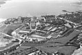
Deutsch: Die Falckensteiner Straße wurde zwischen 1869 und 1874 nach Planung der königlichen Festungsbaubehörde als Querstraße III für die Marinegarnison und Torpedowerke Friedrichsort angelegt und führte ursprünglich von der Anlegestelle Friedrichsort in nördlicher Richtung bis an die Chaussee zum Fort Falckenstein (später verläuft sie um den Friedrichsorter Friedhof herum nach Westen und mündet am Semra-Ertan-Platz in die Straße An der Schanze). Vermutlich um 1900 wurde sie umbenannt.
English: Falckensteiner Straße was laid out between 1869 and 1874 according to plans by the royal fortress construction authority as Cross Street III for the Friedrichsort naval garrison and torpedo works and originally led from the Friedrichsort pier in a northerly direction to the road to Fort Falckenstein (later it runs around the Friedrichsort Cemetery to the west and flows into An der Schanze street at Semra-Ertan-Platz). It was probably renamed around 1900.
Subcategories
This category has the following 3 subcategories, out of 3 total.
F
- Friedhof Friedrichsort (11 F)
W
Media in category "Falckensteiner Straße (Kiel)"
The following 4 files are in this category, out of 4 total.
-
 Luftaufnahme Friedrichsort (Kiel 49.259).jpg 1,024 × 683; 155 KB
-
 Luftaufnahme Friedrichsort (Kiel 49.260).jpg 1,024 × 679; 164 KB
-
 Maschinenbau Kiel AG (MaK) in Friedrichsort (Kiel 74.727).jpg 1,024 × 677; 112 KB
-

.jpg)
.jpg)
_in_Friedrichsort_(Kiel_74.727).jpg)
_f%C3%BCr_h%C3%B6here_L%C3%B6hne_bei_Maschinenbau_Kiel_(MaK)_(Kiel_69.881).jpg)