Category:Exclamation mark warning road signs in the United Kingdom
Jump to navigation
Jump to search
Countries of Europe: Austria · Belgium · Croatia · Czech Republic · Denmark · Finland · France‡ · Germany · Hungary · Iceland · Republic of Ireland · Italy · Luxembourg · Netherlands‡ · Norway · Poland · Slovenia · Spain‡ · Sweden · Switzerland · Turkey‡ · Ukraine · United Kingdom
‡: partly located in Europe
‡: partly located in Europe
Media in category "Exclamation mark warning road signs in the United Kingdom"
The following 57 files are in this category, out of 57 total.
-
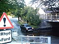 A Ford in the ford - geograph.org.uk - 423898.jpg 640 × 480; 129 KB
-
 A Forest controversy. - geograph.org.uk - 52952.jpg 640 × 462; 82 KB
-
 A423 near Marton, warning signs - geograph.org.uk - 1113230.jpg 640 × 523; 123 KB
-
 An unknown danger - geograph.org.uk - 1579054.jpg 640 × 480; 155 KB
-
 Approaching the Cwm Cilio Cattle Grid - geograph.org.uk - 248918.jpg 640 × 359; 66 KB
-
 Belfast (258), October 2009.JPG 2,848 × 4,272; 4.26 MB
-
 Blind summit - geograph.org.uk - 465307.jpg 640 × 507; 42 KB
-
 Bridge over the River Doon - geograph.org.uk - 1311355.jpg 640 × 480; 78 KB
-
 Car traps on Cambridgeshire Guided Busway.JPG 4,608 × 3,456; 4.75 MB
-

-
 Caution Highway crossing 20m (3965832741).jpg 2,419 × 3,224; 1.68 MB
-
 Chiswick Mall flooded at high tide - geograph.org.uk - 1327767.jpg 640 × 480; 96 KB
-
 Consider Yourself Warned. - panoramio.jpg 3,053 × 1,996; 1.99 MB
-
 Crossroads near Cold Ashby - geograph.org.uk - 184118.jpg 640 × 480; 104 KB
-
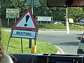 Downend Long Lane Bestival warning sign.jpg 3,648 × 2,736; 5.13 MB
-

-

-
 Flood Warning - geograph.org.uk - 252156.jpg 640 × 480; 98 KB
-
 Ford sign - geograph.org.uk - 442358.jpg 426 × 640; 128 KB
-
 Hardknott sign.JPG 533 × 800; 101 KB
-
 NCN7 at Dalnacardoch (8125812629).jpg 1,280 × 960; 297 KB
-
 Near Low Hunsley - geograph.org.uk - 701859.jpg 640 × 491; 166 KB
-
 Not long to go^ - geograph.org.uk - 403636.jpg 640 × 480; 75 KB
-
 Other danger - geograph.org.uk - 529339.jpg 2,000 × 3,008; 3.76 MB
-
 Potholes road sign, St Ives, Cornwall.jpg 3,104 × 4,672; 5.96 MB
-
 Proceed at your own risk^ - geograph.org.uk - 1335215.jpg 430 × 640; 94 KB
-

-
 Red squirrel road sign - geograph.org.uk - 1465192.jpg 640 × 424; 125 KB
-
 Road closed at Boho - geograph.org.uk - 487438.jpg 640 × 479; 79 KB
-
 Road Signs at Pencraig Hill - geograph.org.uk - 353548.jpg 640 × 466; 130 KB
-
 Road to Rock - geograph.org.uk - 1252086.jpg 640 × 480; 88 KB
-
 Roadsigns outside Dalmellington - geograph.org.uk - 1311324.jpg 640 × 494; 93 KB
-
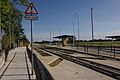 Swavesey guided bus stop - geograph.org.uk - 1503654.jpg 640 × 428; 79 KB
-
 Take care^ - geograph.org.uk - 401515.jpg 480 × 640; 105 KB
-
 Tall warning sign at Snettisham.JPG 2,000 × 3,008; 2.67 MB
-

-
 They're not kidding - geograph.org.uk - 773046.jpg 480 × 640; 55 KB
-
 Torr Road, County Antrim, September 2010 (08).JPG 2,848 × 4,272; 4.21 MB
-
 Traffic queues likely.JPG 1,011 × 809; 227 KB
-

-
 Warning - mountain ahead^ - geograph.org.uk - 1800370.jpg 658 × 1,024; 209 KB
-

-
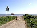
 Warning Sign on the Seafront - geograph.org.uk - 1580790.jpg 640 × 430; 88 KB
-

-

-
 Watchout for Nutkin on the B7000^ - geograph.org.uk - 553971.jpg 640 × 480; 127 KB
-
 Wootton Bridge wildfowl in road sign.JPG 3,712 × 2,088; 3.16 MB
-
 A Bad Sign on the A43 - geograph.org.uk - 143993.jpg 640 × 480; 106 KB
-

-

-

-

-
 Cattle Grid, Danby Road - geograph.org.uk - 121033.jpg 640 × 384; 37 KB
-

-
 Old Bwlch hill - geograph.org.uk - 657860.jpg 640 × 428; 89 KB
-
 Road edge damage, Longstanton, Cambs - geograph.org.uk - 180176.jpg 640 × 480; 295 KB
-


,_October_2009.JPG)


_grid_near_Bedd_Morris,_North_Pembrokeshire_-_geograph.org.uk_-_203521.jpg)
.jpg)


,_Samsonagh_-_geograph.org.uk_-_1599128.jpg)
,_Boho_-_geograph.org.uk_-_1599273.jpg)


.jpg)


.JPG)


