Category:Evangelische Kirche Bad Saarow
Jump to navigation
Jump to search
| Object location | | View all coordinates using: OpenStreetMap |
|---|
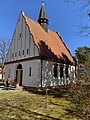
church building in Brandenburg state, Germany  _Saarower_Kirche.jpg)  | |||||
| Upload media | |||||
| Instance of | |||||
|---|---|---|---|---|---|
| Location | Bad Saarow, Oder-Spree District, Brandenburg, Germany | ||||
| Architectural style | |||||
| Architect | |||||
| Inception |
| ||||
 | |||||
Subcategories
This category has only the following subcategory.
Media in category "Evangelische Kirche Bad Saarow"
The following 9 files are in this category, out of 9 total.
-
 Gedenktafel Max Schmeling.JPG 3,648 × 2,056; 3.64 MB
-
 Gedenktafel Kirchstr 9 (Bad Saarow) Saarower Kirche.jpg 1,594 × 1,154; 778 KB
-
 Bad Saarow asv2022-08 img16 Evangelische Kirche.jpg 4,684 × 4,684; 17.5 MB
-
 Bad Saarow kleine Kirche 02-14.jpg 2,291 × 3,054; 3.1 MB
-

-

-
 Evangelische Kirche Bad Saarow Südostansicht.JPG 1,944 × 2,592; 2.77 MB
-
 Evangelische Kirche Bad Saarow Südwestansicht.JPG 1,944 × 2,592; 2.04 MB
-
 Kirchstr 9 (Bad Saarow) Saarower Kirche.jpg 2,857 × 3,813; 4.85 MB


_Saarower_Kirche.jpg)