Category:Esweg 29 (Norg)
Jump to navigation
Jump to search
| Object location | | View all coordinates using: OpenStreetMap |
|---|
 | |||||
| Upload media | |||||
| Instance of |
| ||||
|---|---|---|---|---|---|
| Location | Norg, Drenthe, Netherlands | ||||
| Street address |
| ||||
| Located on street |
| ||||
| Heritage designation |
| ||||
 | |||||
Nederlands: `t Schildershuys
|
This is a category about rijksmonument number 30792
|
| Address |
|
Media in category "Esweg 29 (Norg)"
The following 32 files are in this category, out of 32 total.
-
 Achter- en zijgevel nr. F 167-40 - Norg - 20438690 - RCE.jpg 1,200 × 900; 131 KB
-
 Achter- en zijgevel nr. F 267-38 - Norg - 20438685 - RCE.jpg 1,200 × 900; 137 KB
-
 Achter- en zijgevel nr. F 315-02 - Norg - 20438667 - RCE.jpg 1,200 × 900; 108 KB
-
 Achtergevel nr. F 167-2 - Norg - 20438676 - RCE.jpg 1,200 × 900; 143 KB
-
 Binnenzijde dak nr. F 167-6 - Norg - 20438669 - RCE.jpg 1,200 × 900; 145 KB
-
 Dakconstructie nr. F 167-4 - Norg - 20438671 - RCE.jpg 1,200 × 900; 179 KB
-
 Dubbele inrijdeuren nr. F 167-3 - Norg - 20438674 - RCE.jpg 1,200 × 900; 163 KB
-
 Dubbele inrijdeuren nr. F 267-40 - Norg - 20438683 - RCE.jpg 1,200 × 900; 151 KB
-
 Esweg.29.Norg.jpg 3,352 × 2,093; 1.59 MB
-
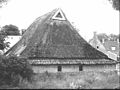
 Exterieur - Norg - 20170074 - RCE.jpg 1,200 × 952; 348 KB
-
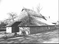
 Exterieur overzicht - Norg - 20321856 - RCE.jpg 1,200 × 1,198; 331 KB
-
 Muuranker nr. F 5-11 - Norg - 20491520 - RCE.jpg 1,200 × 900; 102 KB
-
 Topgevel met muuranker '1717' nr. F 5-10 - Norg - 20491518 - RCE.jpg 1,200 × 900; 84 KB
-
 Voor- en zijgevel bakhuis nr. F 316-03 - Norg - 20438678 - RCE.jpg 1,200 × 900; 131 KB
-
 Voor- en zijgevel bakhuis nr. F 316-04 - Norg - 20438677 - RCE.jpg 1,200 × 900; 125 KB
-
 Voor- en zijgevel nr. F 167-42 - Norg - 20438688 - RCE.jpg 1,200 × 900; 188 KB
-
 Voor- en zijgevel nr. F 267-43 - Norg - 20438680 - RCE.jpg 1,200 × 900; 171 KB
-
 Voor- en zijgevel nr. F 5-8 - Norg - 20491517 - RCE.jpg 1,200 × 900; 194 KB
-
 Voor- en zijgevel nr. F 5-9 - Norg - 20491519 - RCE.jpg 1,200 × 900; 188 KB
-
 Voorgevel nr. F 267-1 - Norg - 20438687 - RCE.jpg 1,200 × 900; 142 KB
-
 Zij- en achtergevel nr. F 267-39 - Norg - 20438684 - RCE.jpg 1,200 × 900; 153 KB
-
 Zij- en achtergevel nr. F 315-03 - Norg - 20438679 - RCE.jpg 1,200 × 900; 138 KB
-
 Zij- en voorgevel nr. F 142-23 - Norg - 20438668 - RCE.jpg 1,200 × 900; 139 KB
-
 Zij- en voorgevel nr. F 167-41 - Norg - 20438689 - RCE.jpg 1,200 × 900; 162 KB
-
 Zij- en voorgevel nr. F 267-2 - Norg - 20438686 - RCE.jpg 1,200 × 900; 110 KB
-
 Zij- en voorgevel nr. F 279-37 - Norg - 20438672 - RCE.jpg 1,200 × 900; 136 KB
-
 Zij- en voorgevel nr. F 279-38 - Norg - 20438675 - RCE.jpg 1,200 × 900; 135 KB
-
 Zijgevel nr. F 167-1 - Norg - 20438673 - RCE.jpg 1,200 × 900; 204 KB
-
 Zijgevel nr. F 267-41 - Norg - 20438682 - RCE.jpg 1,200 × 900; 213 KB
-
 Zijgevel nr. F 267-42 - Norg - 20438681 - RCE.jpg 1,200 × 900; 140 KB
-
 Zijgevel nr. F 315-04 - Norg - 20438691 - RCE.jpg 1,200 × 900; 182 KB
-
 Zolder nr. F 167-5 - Norg - 20438670 - RCE.jpg 1,200 × 900; 164 KB


