Category:Erith
Jump to navigation
Jump to search

district of South East London within the London Borough of Bexley  | |||||
| Upload media | |||||
| Pronunciation audio | |||||
|---|---|---|---|---|---|
| Instance of |
| ||||
| Location | London Borough of Bexley, Greater London, London, England | ||||
| Located in or next to body of water | |||||
 | |||||
Subcategories
This category has the following 13 subcategories, out of 13 total.
2
- 28 and 30, Erith High Street (4 F)
A
C
D
- D. Sebel & Co. (1 F)
- De Luci Fish by Gary Drostle (5 F)
E
- Erith Council Tram (1 F)
- Erith Pier (25 F)
- Erith Playhouse (4 F)
- Erith Town Hall (3 F)
P
- Pubs in Erith (13 F)
S
Media in category "Erith"
The following 72 files are in this category, out of 72 total.
-
 2022-05-14 17-24-17 - 180 at Erith.jpg 3,872 × 2,592; 2.4 MB
-

-

-
 ADM Jetty, Erith II.jpg 4,032 × 3,024; 1.23 MB
-
 ADM Jetty, Erith.jpg 4,032 × 3,024; 959 KB
-
 Admiralty Chart No 1150 River Thames Erith to Broadness, Published 1900.jpg 16,238 × 11,248; 79.87 MB
-
 Admiralty Chart No 3191 River Thames Woolwich to Erith, Published 1901.jpg 16,428 × 11,293; 56.05 MB
-
 Barge on the River Thames.jpg 3,024 × 4,032; 861 KB
-
 Bexley Road, Erith - geograph.org.uk - 1049658.jpg 640 × 480; 77 KB
-
 Bexley Road, Erith - geograph.org.uk - 3909488.jpg 3,488 × 2,616; 1.55 MB
-
 BJ Waters, EMR Erith.jpg 3,024 × 4,032; 1.02 MB
-
 Bosworth House, Erith (01).jpg 3,295 × 4,476; 8.92 MB
-
 Boundary Road, Erith - geograph.org.uk - 1278416.jpg 640 × 455; 109 KB
-
 Boydell Erith.jpg 2,511 × 1,577; 1.57 MB
-
 British Oil & Cake Mills (13665732863).jpg 5,184 × 3,456; 2.04 MB
-
 Christchurch Avenue, Erith - geograph.org.uk - 3909479.jpg 3,488 × 2,616; 1.7 MB
-
 Collapsed Jetty in the Thames Estuary at Erith (01).jpg 4,592 × 3,448; 8.22 MB
-
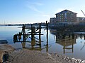 Collapsed Jetty in the Thames Estuary at Erith (02).jpg 4,592 × 3,448; 9.8 MB
-
 Colourful parade of shops, Erith - geograph.org.uk - 3311326.jpg 640 × 427; 85 KB
-
 Compton Place, Erith - geograph.org.uk - 3908705.jpg 3,488 × 2,616; 2.15 MB
-
 Crescent Road, Erith - geograph.org.uk - 3908661.jpg 3,488 × 2,616; 1.45 MB
-
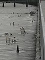
 Embankments at High Spring Tide between Erith and Woolwich (transparent).png 1,004 × 604; 1.01 MB
-
 Embankments at High Spring Tide between Erith and Woolwich.png 1,010 × 610; 659 KB
-
 Erith and District Hospital (geograph 2823208).jpg 4,288 × 3,216; 4.29 MB
-
 Erith explosion 1.jpg 2,658 × 1,711; 1.61 MB
-
 Erith explosion 2.jpg 2,498 × 1,579; 1.79 MB
-
 Erith industrial.jpg 3,072 × 2,304; 1.37 MB
-
 Erith Library at Bexley, Kent (30317194395).jpg 5,089 × 3,393; 11.33 MB
-
 Erith Post Office - geograph.org.uk - 3646976.jpg 640 × 360; 55 KB
-
 Erith Riverside Shopping Centre - geograph.org.uk - 1051514.jpg 640 × 480; 53 KB
-
 Erith Town Hall - geograph.org.uk - 1278414.jpg 640 × 479; 139 KB
-
 Erith, Railway line to Slade Green - geograph.org.uk - 716938.jpg 640 × 480; 107 KB
-
 Erith, Thanet Road - geograph.org.uk - 716263.jpg 640 × 480; 80 KB
-
 Erith, trolley graveyard - geograph.org.uk - 491178.jpg 480 × 640; 62 KB
-
 Erith, William Cory Promenade - geograph.org.uk - 717068.jpg 640 × 480; 72 KB
-
 Former Underground Hospital, Erith and District Hospital (01).jpg 4,234 × 3,013; 11.03 MB
-
 Former Underground Hospital, Erith and District Hospital (02).jpg 4,478 × 3,302; 12.45 MB
-
 Geological Society of London, vol. 25 - Pl. VIII.png 3,887 × 2,364; 803 KB
-
 Glendale Road, Erith - geograph.org.uk - 3909409.jpg 3,488 × 2,616; 2.36 MB
-
 Graffiti artwork on Northumberland Heath Rugby Club pavilion - geograph.org.uk - 2544459.jpg 3,072 × 2,304; 1.62 MB
-
 Horses on Erith Marshes - 2020-09-27.jpg 4,048 × 3,036; 5.47 MB
-
 IKRA, Erith 280621.jpg 720 × 540; 50 KB
-
 IKRA, Erith.jpg 2,387 × 1,790; 404 KB
-
 Lesney Park, Erith - geograph.org.uk - 3909491.jpg 3,488 × 2,616; 2.24 MB
-
 Lincoln Road, Erith - geograph.org.uk - 3908724.jpg 3,488 × 2,616; 1.87 MB
-
 Lower Road, Erith - geograph.org.uk - 5174695.jpg 1,600 × 1,067; 417 KB
-
 Mambocino Coffee, Erith.jpg 3,072 × 2,304; 1.39 MB
-
 Manor Rd - geograph.org.uk - 3743281.jpg 640 × 430; 55 KB
-
 Manor Road, Erith (2) - geograph.org.uk - 226963.jpg 640 × 480; 109 KB
-
 Manor Road, Erith - geograph.org.uk - 226960.jpg 640 × 480; 96 KB
-
 Manor Road, Erith - geograph.org.uk - 3908656.jpg 3,488 × 2,616; 2.05 MB
-
 Manor Road, Erith - geograph.org.uk - 4521645.jpg 4,000 × 2,664; 1.4 MB
-
 Maxim-Nordenfeldt Factory, Erith - Cassier's 1895-04.png 3,450 × 2,442; 5.72 MB
-
 Meyer Road, Erith - geograph.org.uk - 3909497.jpg 3,488 × 2,616; 1.57 MB
-

-
 Old Pier, Erith.jpg 4,032 × 3,024; 1.76 MB
-
 Park Crescent Road, Erith - geograph.org.uk - 3909481.jpg 3,488 × 2,616; 2.25 MB
-
 Park Gardens, Erith - geograph.org.uk - 3909412.jpg 3,488 × 2,616; 1.96 MB
-
 Pier Road, Erith - geograph.org.uk - 3908703.jpg 3,488 × 2,616; 2.17 MB
-
 Riverside apartments, Erith - geograph.org.uk - 198210.jpg 640 × 480; 54 KB
-
 Small boat on the River Thames.jpg 4,032 × 3,024; 538 KB
-
 St. John's Hall, Erith - geograph.org.uk - 2548982.jpg 3,072 × 2,304; 1.82 MB
-
 Sustrans milepost, Crayford Ness - geograph.org.uk - 195207.jpg 480 × 640; 73 KB
-
 Sustrans milepost, Erith - geograph.org.uk - 753022.jpg 462 × 639; 57 KB
-
 Thames Foreshore - geograph.org.uk - 936016.jpg 640 × 480; 82 KB
-
 The Lodge, The Oaks, Erith circa 1881 (geograph 3883579).jpg 1,024 × 637; 557 KB
-
 The Thames at Erith, 1966 - geograph.org.uk - 1319338.jpg 640 × 546; 97 KB
-
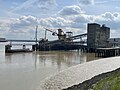
 The view from Erith Pier.jpg 4,032 × 3,024; 632 KB
-
 Valley Road, Erith - geograph.org.uk - 3909420.jpg 3,488 × 2,616; 2.27 MB
-
 View of Coldharbour across the Thames from Erith.jpg 4,592 × 3,448; 10.5 MB
-
 West Street, Erith - geograph.org.uk - 2764767.jpg 1,024 × 768; 178 KB
-
 West Street, Erith - geograph.org.uk - 3909454.jpg 3,488 × 2,616; 2.28 MB

.jpg)
.jpg)


.jpg)


.jpg)

.jpg)
.jpg)


.jpg)


.jpg)


.jpg)
.jpg)


_-_geograph.org.uk_-_226963.jpg)


.jpg)


.png)