Category:English-language maps of California
Jump to navigation
Jump to search
States of the United States: Alabama · Alaska · Arkansas · California · Florida · Maryland · Massachusetts · New Jersey · New Mexico · New York · North Carolina · Ohio · Oklahoma · Pennsylvania · Texas · Utah – Washington, D.C.
Subcategories
This category has the following 3 subcategories, out of 3 total.
Media in category "English-language maps of California"
The following 70 files are in this category, out of 70 total.
-
-
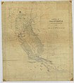
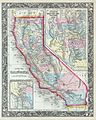 1860 Mitchell's Map of California - Geographicus - CA-m-1860.jpg 3,302 × 4,131; 3.69 MB
-
 1866 Mitchell Map of California - Geographicus - California-mitchell-1866.jpg 2,766 × 3,500; 3.4 MB
-
 1872 Mitchell Map of California w- San Francisco Inset - Geographicus - CA-mitchell-1872.jpg 3,402 × 5,000; 5.53 MB
-
 1876 California Nevada.jpg 2,808 × 3,896; 2.69 MB
-
 1881 Mitchell Map of California w- San Francisco Inset - Geographicus - CA-m-1881.jpg 2,363 × 3,500; 2.24 MB
-

-

-
 Admiralty Chart No 591 Habour of San Francisco, Published 1833.jpg 13,286 × 9,354; 22.7 MB
-
 Base map of California. LOC 2005625109.jpg 10,982 × 20,293; 28.16 MB
-
 Ca-regions.png 874 × 995; 210 KB
-
 Ca-regions.svg 925 × 1,053; 188 KB
-
 California - DPLA - 925292d3626ed36e25a3545bbe685f48.jpg 5,352 × 7,000; 6.87 MB
-
 California State Highway Map (1981).jpg 7,410 × 16,145; 30.35 MB
-
 City of San Francisco and it's vicinity, California LOC 2006626017.jpg 8,808 × 14,209; 16.15 MB
-
 Comissioners Official Railway Map of California. - NARA - 103396556.jpg 8,596 × 11,398; 7.37 MB
-
 Drought Monitor, California May 17, 2022.png 1,056 × 816; 58 KB
-
 Earthquake shaking potential for California, Spring 2003 LOC 2003683500.jpg 5,342 × 6,812; 5.41 MB
-
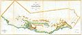
 Keddie's map of Plumas County, California LOC 2012592094-1.jpg 20,883 × 16,035; 69.77 MB
-

-

-
 Map of California and Nevada (8346882486).jpg 649 × 800; 111 KB
-

-

-
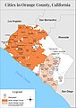
 Map of Orange County, California LOC 2012592100.jpg 17,044 × 16,417; 28.99 MB
-
 Map of Public Surveys in California & Nevada - NARA - 109182644.jpg 14,400 × 14,460; 21.47 MB
-
 Map of Public Surveys in California & Nevada - NARA - 109182652.jpg 14,176 × 15,444; 21.76 MB
-
 Map of Public Surveys in California & Nevada - NARA - 84785986.jpg 9,280 × 11,135; 13.15 MB
-
 Map of Public Surveys in California - NARA - 109182509.jpg 13,408 × 14,856; 21.86 MB
-
 Map of Public Surveys in California - NARA - 109182634.jpg 14,400 × 15,765; 19.68 MB
-
 Map of Public Surveys in California - NARA - 109182636.jpg 12,576 × 14,919; 20.78 MB
-
 Map of Public Surveys in California - NARA - 109182640.jpg 14,400 × 15,181; 15.66 MB
-
 Map of Public Surveys in California - NARA - 109182650.jpg 13,664 × 14,422; 20.28 MB
-

-

-

-
 Map of Public Surveys in California to Accompany Report of Surveyor General - NARA - 23812176.jpg 10,272 × 11,797; 9.07 MB
-

-
 Map of Public Surveys in California to Accompany Report of Surveyor General - NARA - 23812195.jpg 10,784 × 11,101; 9.83 MB
-
 Map of Public Surveys in California to Accompany Report of Surveyor General - NARA - 23812206.jpg 10,688 × 10,814; 10.54 MB
-

-

-
 Map of San Francisco...for Banker's City Directory LCCN2002697751.jpg 1,536 × 1,273; 418 KB
-
 Map of Sonoma County 1884.jpg 2,587 × 2,217; 1.21 MB
-
-
 Map of the Kern Delta, Kern County, California LOC 2012590100.jpg 8,209 × 6,626; 8.91 MB
-

-
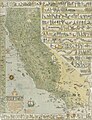
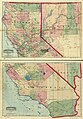
 Map of the State of California - NARA - 23812146.jpg 9,280 × 10,554; 7.86 MB
-
 Map of the State of California - NARA - 23812212.jpg 10,048 × 13,138; 10.62 MB
-
 Map of the State of California - NARA - 23812261.jpg 9,664 × 10,956; 8.27 MB
-

-

-

-
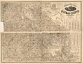
 Map of Tulare County, State of California LOC 2012592104.jpg 20,008 × 10,890; 31.75 MB
-

-
 Map-of-orange-county-california.jpg 2,500 × 3,540; 779 KB
-

-

-
 New commercial and topographical rail road map & guide of California and Nevada. LOC 98688450.jpg 7,264 × 10,432; 11.57 MB
-
 Official map of Amador County, California. - approved by the Board of Supervisors LOC 2012590176.jpg 12,214 × 7,891; 13.82 MB
-

-
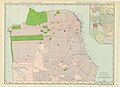
 Official map of San Francisco. LOC 76695582.jpg 6,011 × 7,587; 6.77 MB
-
 Official map of Siskiyou County, State of California LOC 2012592101.jpg 21,418 × 13,660; 44.42 MB
-
 Official map of Sutter County, California LOC 2012590097.jpg 9,898 × 13,244; 15.6 MB
-

-

-
 Reconnaissance erosion survey of the state of California - btv1b53189493n.jpg 12,150 × 13,926; 16.34 MB
-
 San Francisco - DPLA - 22ccd01325d8b3ce44644e699d43b921 (page 1).jpg 8,512 × 6,176; 10.09 MB
-
 San Francisco - DPLA - 22ccd01325d8b3ce44644e699d43b921 (page 2).pdf 4,254 × 3,087; 5.64 MB
-
 San Francisco City Map - DPLA - f4f477c878a1bc5183a2e48e592b3a73.jpg 6,536 × 3,486; 3.31 MB
_-_Geographicus_-_California-landsurvey-1854.jpg)


.jpg)


.jpg)


.jpg)
.jpg)


.jpg)
