Category:Eemwijk (Voorburg)
Jump to navigation
Jump to search
| Object location | | View all coordinates using: OpenStreetMap |
|---|
building in Leidschendam-Voorburg, Netherlands _zijaanzicht.jpg) | |||||
| Upload media | |||||
| Instance of | |||||
|---|---|---|---|---|---|
| Part of | |||||
| Location | Voorburg, Leidschendam-Voorburg, South Holland, Netherlands | ||||
| Street address |
| ||||
| Located on street | |||||
| Heritage designation |
| ||||
 | |||||
|
This is a category about rijksmonumentcomplex number 524444
|
Landhuis:
|
This is a category about rijksmonument number 524445
|
Tuinmanswoning:
|
This is a category about rijksmonument number 524446
|
Toegangshek:
|
This is a category about rijksmonument number 524447
|
Orangerie:
|
This is a category about rijksmonument number 525976
|
| Address |
|
Media in category "Eemwijk (Voorburg)"
The following 68 files are in this category, out of 68 total.
-

-

-

-

-

-

-

-

-

-

-

-

-

-

-

-

-

-

-

-

-

-

-
-

-

-

-

-

-

-

-

-

-

-

-

-

-

-

-

-

-

-

-

-

-

-
 Interieur, eerste verdieping, overzicht trappenhuis - Voorburg - 20379601 - RCE.jpg 1,200 × 1,200; 252 KB
-
 Interieur, eerste verdieping, overzicht trappenhuis - Voorburg - 20379602 - RCE.jpg 1,200 × 1,200; 215 KB
-

-
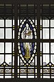
 Interieur, trappenhuis, glas-in-lood ramen - Voorburg - 20376291 - RCE.jpg 1,174 × 1,200; 381 KB
-
 Koetshuis, overzicht achterzijde met tuin - Voorburg - 20379620 - RCE.jpg 1,200 × 1,200; 479 KB
-
 Koetshuis, overzicht rechterzijde - Voorburg - 20379619 - RCE.jpg 1,200 × 1,200; 447 KB
-
 Overzicht achtergevel met tuin - Voorburg - 20379621 - RCE.jpg 1,200 × 1,200; 341 KB
-
 Overzicht achtergevel met tuin - Voorburg - 20379622 - RCE.jpg 1,200 × 1,200; 345 KB
-
 Overzicht achtergevel met tuin - Voorburg - 20379623 - RCE.jpg 1,200 × 1,200; 331 KB
-
 Overzicht koetshuis, voorgevel en linker zijgevel - Voorburg - 20379616 - RCE.jpg 1,200 × 1,200; 430 KB
-
 Overzicht koetshuis, voorzijde - Voorburg - 20379614 - RCE.jpg 1,200 × 1,200; 460 KB
-
 Overzicht linker zijgevel - Voorburg - 20379609 - RCE.jpg 1,200 × 1,200; 325 KB
-
 Overzicht linker zijgevel - Voorburg - 20379611 - RCE.jpg 798 × 1,200; 230 KB
-
 Overzicht rechter zijgevel en achtergevel - Voorburg - 20379610 - RCE.jpg 1,200 × 1,200; 332 KB
-

-

-
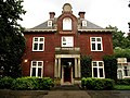
 Overzicht voorgevel - Voorburg - 20379613 - RCE.jpg 798 × 1,200; 246 KB
-
 Voorburg - Oosteinde 116 (RM524445) zijaanzicht.jpg 3,264 × 2,448; 2 MB
-
 Voorburg - Oosteinde 116 (RM524445).jpg 3,264 × 2,448; 2.09 MB
-
 Voorburg - Oosteinde 116 (RM524446).jpg 3,264 × 2,448; 2.42 MB
-
 Voorburg - Oosteinde bij 116 (RM524447) vooraanzicht.jpg 3,264 × 2,448; 2.72 MB
-
 Voorburg - Oosteinde bij 116 (RM524447).jpg 3,264 × 2,448; 2.77 MB
-
 Voorburg - Oosteinde bij 116 (RM525976).jpg 3,264 × 2,448; 2.43 MB
,_schouw_met_trompe-l%C3%B3eil_in_de_boezem_-_Voorburg_-_20379599_-_RCE.jpg)


_met_schouw,_trompe-l%C3%B3eil_in_de_boezem_-_Voorburg_-_20379600_-_RCE.jpg)
_-_Voorburg_-_20379590_-_RCE.jpg)
_-_Voorburg_-_20379591_-_RCE.jpg)
_-_Voorburg_-_20379592_-_RCE.jpg)
_-_Voorburg_-_20379594_-_RCE.jpg)

_-_Voorburg_-_20379595_-_RCE.jpg)


,_schouw_-_Voorburg_-_20379596_-_RCE.jpg)


,_met_schouw_-_Voorburg_-_20379605_-_RCE.jpg)
_-_Voorburg_-_20379607_-_RCE.jpg)
_-_Voorburg_-_20379608_-_RCE.jpg)
,_met_schouw_-_Voorburg_-_20379603_-_RCE.jpg)
,_met_schouw_-_Voorburg_-_20379604_-_RCE.jpg)


.jpg)
.jpg)
_vooraanzicht.jpg)
.jpg)
.jpg)