Category:Edlingham
Jump to navigation
Jump to search
village and civil parish in Northumberland, England Aug2004).jpg) | |||||
| Upload media | |||||
| Instance of | |||||
|---|---|---|---|---|---|
| Location | Northumberland, North East England, England | ||||
| Said to be the same as | Edlingham | ||||
 | |||||
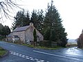
English: Edlingham is a small village and civil parish in Northumberland in the north of England. At the 2001 census it had a population of 196. The road to Alnwick passes close by the village and the town of Rothbury is about away.

Subcategories
This category has the following 13 subcategories, out of 13 total.
A
- Abberwick (6 F)
B
- Black Lough, Northumberland (3 F)
C
- Caller Crags (7 F)
- Corby's Crags (10 F)
E
- Edlingham Castle (55 F)
- Edlingham Viaduct (16 F)
L
- Lemmington Hall (13 F)
O
- Overthwarts (8 F)
Media in category "Edlingham"
The following 200 files are in this category, out of 663 total.
(previous page) (next page)-
 'Pre owned' combine - geograph.org.uk - 5339953.jpg 4,592 × 3,448; 2.36 MB
-
 A curiosity^ - geograph.org.uk - 4469212.jpg 1,600 × 1,200; 515 KB
-
 A fine bridge joining two pastures - geograph.org.uk - 3359570.jpg 1,600 × 1,052; 439 KB
-
 A ruined snow fence - geograph.org.uk - 3762954.jpg 640 × 360; 212 KB
-
 A stand of Beech trees - geograph.org.uk - 1742718.jpg 4,000 × 3,000; 4.52 MB
-
 A stretch of minor road between Rough Castles and Coeburn - geograph.org.uk - 5995967.jpg 4,000 × 3,000; 3.93 MB
-
 A track into the conifer woodland. - geograph.org.uk - 527569.jpg 640 × 430; 168 KB
-
 A697 - geograph.org.uk - 3761110.jpg 640 × 360; 213 KB
-
 A697 - geograph.org.uk - 3761123.jpg 640 × 360; 236 KB
-
 A697 - geograph.org.uk - 3765135.jpg 640 × 360; 208 KB
-
 A697 curving up around Longframlington Common - geograph.org.uk - 3792474.jpg 1,600 × 1,200; 218 KB
-
 A697 lay-by - geograph.org.uk - 4676500.jpg 640 × 480; 74 KB
-
 A697 northbound - geograph.org.uk - 3174465.jpg 640 × 480; 37 KB
-
 A697 northbound - geograph.org.uk - 3174470.jpg 640 × 480; 41 KB
-
 A697 northbound - geograph.org.uk - 3174472.jpg 640 × 480; 39 KB
-
 A697 northbound - geograph.org.uk - 3393057.jpg 640 × 480; 50 KB
-
 A697 northbound - geograph.org.uk - 3393060.jpg 640 × 480; 55 KB
-
 A697 northbound - geograph.org.uk - 3393061.jpg 640 × 480; 44 KB
-
 A697 northbound - geograph.org.uk - 3393063.jpg 640 × 480; 38 KB
-
 A697 northbound - geograph.org.uk - 3393069.jpg 640 × 480; 34 KB
-
 A697 northbound - geograph.org.uk - 3765141.jpg 640 × 360; 194 KB
-
 Abandoned wall onThorny Knowe - geograph.org.uk - 613884.jpg 480 × 640; 89 KB
-
 Abberwick Farmhouse - geograph.org.uk - 4665441.jpg 1,066 × 800; 296 KB
-
 Abberwick Ford - geograph.org.uk - 3981127.jpg 3,872 × 2,592; 4.8 MB
-
 Abberwick Mill - geograph.org.uk - 2989949.jpg 1,600 × 1,238; 362 KB
-
 Abberwick Mill - geograph.org.uk - 4665450.jpg 1,066 × 800; 172 KB
-
 Above the Edlington Burn - geograph.org.uk - 5912957.jpg 1,024 × 576; 351 KB
-
 Access bridge under the old Alnwick ^ Cornhill Railway - geograph.org.uk - 6326041.jpg 1,600 × 1,370; 339 KB
-
 Access point - geograph.org.uk - 1522376.jpg 640 × 480; 109 KB
-
 Access to Coe Crags Wood - geograph.org.uk - 4131571.jpg 1,600 × 1,186; 467 KB
-
 Access to Edlingham Crags - geograph.org.uk - 3297695.jpg 1,600 × 1,264; 378 KB
-
 Access to Edlingham Woods - geograph.org.uk - 3297742.jpg 1,600 × 1,254; 322 KB
-
 Access to Oxen Wood - geograph.org.uk - 3283987.jpg 1,600 × 1,200; 336 KB
-
 Across Swinhope - geograph.org.uk - 5912949.jpg 1,024 × 576; 268 KB
-
 Across the valley from B6341 - geograph.org.uk - 6177284.jpg 4,608 × 3,456; 5.28 MB
-
 Air shaft - geograph.org.uk - 3359589.jpg 1,600 × 1,187; 354 KB
-
 Air Shaft - geograph.org.uk - 4048273.jpg 2,463 × 3,813; 1.8 MB
-
 Alnwick Moor - geograph.org.uk - 616436.jpg 640 × 480; 70 KB
-
 Along the edge of the hills - geograph.org.uk - 5961215.jpg 3,000 × 3,470; 2.34 MB
-
 An Old Bridge - geograph.org.uk - 1742749.jpg 4,000 × 3,000; 5.88 MB
-
 Approaching Edlingham - geograph.org.uk - 3359396.jpg 1,600 × 1,114; 404 KB
-
 Approaching Learchild Crossing Cottage - geograph.org.uk - 5317569.jpg 1,600 × 1,034; 286 KB
-
 Approaching Thrunton - geograph.org.uk - 3777109.jpg 1,600 × 1,200; 196 KB
-
 Approaching Thrunton Wood - geograph.org.uk - 3583373.jpg 1,600 × 1,035; 263 KB
-
 Aqueduct over the old Alnwick ^ Cornhill Railway - geograph.org.uk - 6325159.jpg 1,600 × 1,200; 548 KB
-

-

-
 Arable field east of Lemmington Hall - geograph.org.uk - 542537.jpg 640 × 480; 99 KB
-
 Arable field north of Lemmington Hall - geograph.org.uk - 2350208.jpg 1,024 × 768; 202 KB
-
 Arum italicum near Lemmington Hall - geograph.org.uk - 2350198.jpg 1,024 × 768; 265 KB
-
 Autumn mists in the Aln valley - geograph.org.uk - 5219902.jpg 1,600 × 1,067; 136 KB
-
 Autumn tints in Northumberland - geograph.org.uk - 2130274.jpg 640 × 480; 72 KB
-
 B6341 - geograph.org.uk - 5912933.jpg 1,024 × 576; 300 KB
-
 B6341 dropping down to Swinhope Bridge - geograph.org.uk - 6177295.jpg 4,608 × 3,456; 6.23 MB
-
 B6341 southbound - geograph.org.uk - 4720332.jpg 640 × 480; 46 KB
-
 B6341, Gowk Hill - geograph.org.uk - 3761103.jpg 640 × 360; 206 KB
-
 Bank Top - geograph.org.uk - 4047634.jpg 3,729 × 2,154; 1.64 MB
-
 Bank Wood near Lemmington Hall - geograph.org.uk - 2350182.jpg 1,024 × 768; 408 KB
-
 Banktop - geograph.org.uk - 303462.jpg 640 × 480; 100 KB
-
 Banktop crossing - geograph.org.uk - 3284068.jpg 1,600 × 1,080; 360 KB
-
 Barn south-east of Demesne, Edlingham - geograph.org.uk - 2649089.jpg 1,024 × 768; 240 KB
-
 Battle Bridge over Edlingham Burn - geograph.org.uk - 2989930.jpg 893 × 1,000; 280 KB
-

-
 Beeches near Bolton - geograph.org.uk - 2190465.jpg 640 × 445; 217 KB
-
 Beehives in the forest - geograph.org.uk - 4131456.jpg 1,600 × 1,200; 587 KB
-
 Beehives in the wood - geograph.org.uk - 3655277.jpg 640 × 480; 106 KB
-
 Bell pit - geograph.org.uk - 4469180.jpg 1,600 × 1,134; 402 KB
-
 Benchmark on Corby's Bridge - geograph.org.uk - 4575714.jpg 1,536 × 2,048; 777 KB
-
 Beware of the notices (and typos) - geograph.org.uk - 5912963.jpg 1,024 × 576; 389 KB
-
 Bigges' Pillar - geograph.org.uk - 4050663.jpg 4,320 × 3,240; 5.65 MB
-
 Bigges' Pillar - geograph.org.uk - 4050675.jpg 1,600 × 1,200; 472 KB
-
 Bigges' Pillar, Edlingham Woods - geograph.org.uk - 1140110.jpg 640 × 480; 106 KB
-
 Birds and Brizlee Wood Radar Dome - geograph.org.uk - 5521140.jpg 1,600 × 899; 143 KB
-
 Birsley Woodside - geograph.org.uk - 4665620.jpg 1,066 × 800; 257 KB
-
 Black Lough - geograph.org.uk - 3562437.jpg 1,600 × 1,123; 330 KB
-
 Blackthorn blossom in hedgerow below Lumby Law - geograph.org.uk - 2348481.jpg 1,024 × 769; 410 KB
-
 Bolton Bridge - geograph.org.uk - 2989864.jpg 1,600 × 1,200; 457 KB
-
 Bolton Bridge - geograph.org.uk - 4665500.jpg 1,066 × 800; 238 KB
-
 Bolton Mill - geograph.org.uk - 4047662.jpg 3,601 × 1,789; 1.64 MB
-
 Boundary stone east of Long Crag - geograph.org.uk - 4637756.jpg 1,024 × 768; 254 KB
-
 Boundary stone on Alnwick Moor - geograph.org.uk - 4579272.jpg 1,536 × 2,048; 1.66 MB
-
 Boundary stone on Glantlees Hill - geograph.org.uk - 4050102.jpg 1,600 × 1,200; 551 KB
-
-
 Boundary wall changes to a fence - geograph.org.uk - 4050013.jpg 1,600 × 1,200; 376 KB
-
 Brickworks at Thrunton - geograph.org.uk - 3777105.jpg 1,600 × 1,200; 207 KB
-

-
 Bridge End Farm Cottages - geograph.org.uk - 4665502.jpg 1,066 × 800; 164 KB
-
 Bridge over Corby's Letch - geograph.org.uk - 4575719.jpg 2,048 × 1,536; 945 KB
-
 Bridge over River Aln - geograph.org.uk - 4665459.jpg 1,066 × 800; 348 KB
-
 Bridge over stream - geograph.org.uk - 1743323.jpg 4,000 × 3,000; 4.51 MB
-

-
 Bridleway heading to Overthwarts - geograph.org.uk - 3359703.jpg 1,600 × 1,200; 201 KB
-
 Bridleway towards Edlingham - geograph.org.uk - 4445518.jpg 1,066 × 800; 235 KB
-
 Bridleway towards Snook Bank - geograph.org.uk - 4445617.jpg 1,066 × 800; 293 KB
-
 Bridleway towards Wellhope - geograph.org.uk - 4445580.jpg 1,066 × 800; 285 KB
-
 Bridleway west of Overthwarts - geograph.org.uk - 2348571.jpg 1,024 × 769; 231 KB
-
 Bridleway west of Overthwarts - geograph.org.uk - 2348585.jpg 1,024 × 768; 243 KB
-
 Brizlee Wood Radar dome - geograph.org.uk - 3283959.jpg 1,600 × 1,200; 304 KB
-
 Brizlee Wood Radar Dome - geograph.org.uk - 5520522.jpg 1,600 × 1,067; 231 KB
-
 Broome Wood - geograph.org.uk - 2350137.jpg 1,024 × 768; 227 KB
-
 Burnt heather at Wide Hope - geograph.org.uk - 4575592.jpg 2,048 × 1,536; 1.39 MB
-
 Cairn east of Coe Crags - geograph.org.uk - 4638057.jpg 1,024 × 768; 218 KB
-
 Cairn in the heather - geograph.org.uk - 3562292.jpg 1,600 × 1,200; 412 KB
-
 Cairn on Coe Crags - geograph.org.uk - 4129868.jpg 1,600 × 1,200; 396 KB
-
 Carpet of cotton grass - geograph.org.uk - 3562286.jpg 1,600 × 1,200; 413 KB
-
 Cattle and sheep under Cloudy Crags - geograph.org.uk - 2991197.jpg 1,600 × 1,200; 216 KB
-
 Cattle between the church and the castle - geograph.org.uk - 2479031.jpg 4,288 × 3,216; 1.89 MB
-
 Church of St John the Baptist - geograph.org.uk - 5887106.jpg 4,320 × 2,967; 2.17 MB
-
 Clear area by stream in Edlingham Wood - geograph.org.uk - 2648516.jpg 1,024 × 768; 351 KB
-
 Clear felling in Edlingham Woods - geograph.org.uk - 4050094.jpg 1,600 × 1,230; 283 KB
-
 Cloudy Crags Drive - geograph.org.uk - 5655433.jpg 1,600 × 1,067; 301 KB
-
 Coe Burn - geograph.org.uk - 3583232.jpg 1,600 × 1,200; 605 KB
-
 Coe Crags - geograph.org.uk - 3655300.jpg 640 × 480; 49 KB
-
 Coe Crags - geograph.org.uk - 4637916.jpg 1,024 × 768; 224 KB
-
 Coe Crags from the west - geograph.org.uk - 4637905.jpg 1,024 × 768; 278 KB
-
 Combine graveyard - geograph.org.uk - 5339946.jpg 4,592 × 3,448; 2.94 MB
-
 Coming out of the cutting - geograph.org.uk - 6326075.jpg 1,600 × 1,200; 384 KB
-
 Communications mast beside A697 - geograph.org.uk - 3583245.jpg 1,600 × 931; 184 KB
-
 Corby's Bridge Iron Age and Romano-British settlement - geograph.org.uk - 4469113.jpg 1,600 × 1,200; 567 KB
-
 Corby's Crags - geograph.org.uk - 4291647.jpg 1,000 × 667; 402 KB
-
 Corby's Crags - geograph.org.uk - 5887099.jpg 3,240 × 4,320; 3.24 MB
-
 Corby's Crags - geograph.org.uk - 5912923.jpg 1,024 × 576; 350 KB
-
 Corby's Crags - geograph.org.uk - 5912926.jpg 1,024 × 576; 308 KB
-
 Corby's Letch waterfall - geograph.org.uk - 2239836.jpg 3,567 × 3,000; 5.24 MB
-
 Cottage east of Wandystead - geograph.org.uk - 2676897.jpg 1,024 × 770; 225 KB
-
 Cottage west of Lemmington Branch - geograph.org.uk - 2349249.jpg 1,024 × 768; 264 KB
-
 Cottage west of Lemmington Branch - geograph.org.uk - 2350110.jpg 1,024 × 768; 310 KB
-
 Cottages at Edlingham - geograph.org.uk - 4445491.jpg 1,066 × 800; 285 KB
-
 Cottages at Edlingham - geograph.org.uk - 4445503.jpg 1,066 × 800; 227 KB
-
 Cottages at Lemmington Hall - geograph.org.uk - 4665394.jpg 1,066 × 800; 241 KB
-
 Cottages beside the Edlingham Burn - geograph.org.uk - 3017423.jpg 1,600 × 1,200; 398 KB
-
 Cottages, Edlingham - geograph.org.uk - 2350894.jpg 1,024 × 768; 236 KB
-
 Cottages, Edlingham - geograph.org.uk - 2350925.jpg 1,024 × 768; 240 KB
-
 Cotton grass (Eriophorum) - geograph.org.uk - 3562280.jpg 1,600 × 1,200; 448 KB
-
 Country road - geograph.org.uk - 4720323.jpg 640 × 480; 62 KB
-
 Country road near Bolton (1) - geograph.org.uk - 2190437.jpg 640 × 419; 162 KB
-
 Country road near Bolton (2) - geograph.org.uk - 2190450.jpg 640 × 406; 174 KB
-
 Country road near Bolton (3) - geograph.org.uk - 2190456.jpg 640 × 394; 157 KB
-
 Cows and calves near Lumby Law - geograph.org.uk - 2350794.jpg 1,024 × 769; 271 KB
-

-
 Crags above the B6341 - geograph.org.uk - 4579212.jpg 2,048 × 1,536; 1.06 MB
-
 Crossroads at Banktop - geograph.org.uk - 4579235.jpg 2,048 × 1,536; 1.68 MB
-
 Crossroads B6341 and A697 at New Moor House - geograph.org.uk - 6180186.jpg 3,843 × 2,879; 4.78 MB
-
 Cultivated rhododendron, Lemminton Wood - geograph.org.uk - 2348804.jpg 1,024 × 768; 382 KB
-
 Cultivation terraces, Lemmington Hall parkland - geograph.org.uk - 2350700.jpg 1,024 × 768; 285 KB
-
 Cunyan Crags viewed from Alnwick Moor - geograph.org.uk - 5295839.jpg 1,600 × 1,129; 174 KB
-
 Cup and Ring marked stone near Wellhope - geograph.org.uk - 1140043.jpg 640 × 480; 115 KB
-
 Daffodils by a gateway - geograph.org.uk - 2353955.jpg 4,000 × 3,000; 5.91 MB
-
 Damp pasture, Learchild Moor - geograph.org.uk - 3765137.jpg 640 × 360; 207 KB
-
 Deep in Edlingham Woods - geograph.org.uk - 4050003.jpg 1,600 × 1,200; 482 KB
-
 Descending from Coe Crags - geograph.org.uk - 4131528.jpg 1,600 × 1,200; 498 KB
-

-
 Devil's Causeway crossing Rimside Moor - geograph.org.uk - 2675398.jpg 1,024 × 768; 341 KB
-
 Dilapidated footbridge - geograph.org.uk - 2990277.jpg 1,600 × 1,200; 605 KB
-
 Distant view of Edlingham - geograph.org.uk - 1137649.jpg 640 × 480; 72 KB
-
 Disused Railway Line - geograph.org.uk - 4665357.jpg 1,066 × 800; 312 KB
-
 Disused railway south-east of Lumby Law - geograph.org.uk - 2348492.jpg 1,024 × 768; 254 KB
-
 Disused railway south-east of Lumby Law - geograph.org.uk - 2348496.jpg 1,024 × 768; 358 KB
-
 Disused railway viaduct - geograph.org.uk - 3012190.jpg 1,600 × 1,224; 270 KB
-
 Disused railway, Lemmington Wood - geograph.org.uk - 2348822.jpg 1,024 × 768; 310 KB
-
 Disused railway, Lemmington Wood - geograph.org.uk - 2348825.jpg 1,024 × 768; 397 KB
-
 Downhill View - geograph.org.uk - 1029775.jpg 640 × 480; 96 KB
-
 Drive to Glen Aln - geograph.org.uk - 4665399.jpg 1,066 × 800; 402 KB
-
 Eastern edge of Wide Hope forest - geograph.org.uk - 3562416.jpg 1,600 × 1,101; 316 KB
-
 Ecclesiastical gate fixing - geograph.org.uk - 3012172.jpg 1,600 × 1,200; 452 KB
-
 Edge of bank of coastal fret - geograph.org.uk - 4088425.jpg 1,600 × 1,200; 258 KB
-
 Edlingham - geograph.org.uk - 2745792.jpg 3,855 × 2,137; 981 KB
-
 Edlingham - geograph.org.uk - 4048270.jpg 3,100 × 2,470; 1.43 MB
-
 Edlingham - geograph.org.uk - 5912952.jpg 1,024 × 576; 231 KB
-
 Edlingham - geograph.org.uk - 616240.jpg 640 × 480; 51 KB
-
 Edlingham 2020-07-14 01.jpg 5,568 × 3,712; 13.23 MB
-
 Edlingham 2020-07-14 04.jpg 5,568 × 3,712; 16.51 MB
-
 Edlingham 2020-07-14 05.jpg 5,568 × 3,712; 16.34 MB
-
 Edlingham Burn - geograph.org.uk - 2348531.jpg 1,024 × 768; 450 KB
-
 Edlingham Burn - geograph.org.uk - 2990255.jpg 1,600 × 1,200; 542 KB
-
 Edlingham Burn - geograph.org.uk - 3011973.jpg 1,600 × 1,171; 541 KB
-
 Edlingham Burn - geograph.org.uk - 3359632.jpg 1,600 × 1,200; 585 KB
-
 Edlingham Burn - geograph.org.uk - 3359687.jpg 1,600 × 1,200; 579 KB
-
 Edlingham Burn - geograph.org.uk - 3359768.jpg 1,600 × 1,200; 519 KB
-
 Edlingham Burn - geograph.org.uk - 4445542.jpg 1,066 × 800; 455 KB
-
 Edlingham Burn - geograph.org.uk - 4445721.jpg 1,066 × 800; 474 KB
-
 Edlingham Burn - geograph.org.uk - 4575634.jpg 2,048 × 1,536; 1.63 MB
-
 Edlingham Castle - geograph.org.uk - 5887126.jpg 3,825 × 2,941; 2.52 MB
-
 Edlingham Castle - geograph.org.uk - 5960653.jpg 2,937 × 2,551; 1.49 MB
-
 Edlingham Castle - through an archway in the tower - geograph.org.uk - 5960656.jpg 3,000 × 3,625; 2.11 MB
-
 Edlingham Castle - through the site of the gatehouse - geograph.org.uk - 5960654.jpg 3,000 × 3,774; 2.24 MB
-

-
 Edlingham Church - geograph.org.uk - 5975561.jpg 1,600 × 1,200; 411 KB
-
 Edlingham Crags - geograph.org.uk - 3562254.jpg 1,600 × 1,200; 497 KB
-
 Edlingham Crags - geograph.org.uk - 5912990.jpg 1,024 × 576; 272 KB
-
 Edlingham Railway Tunnel - geograph.org.uk - 956985.jpg 640 × 427; 144 KB
-
 Edlingham viaduct - geograph.org.uk - 1895334.jpg 4,288 × 2,848; 2.95 MB
-
 Edlingham viaduct - geograph.org.uk - 2479028.jpg 4,288 × 3,216; 3.53 MB
-
 Edlingham Viaduct - geograph.org.uk - 5619284.jpg 1,024 × 768; 136 KB
-
 Edlingham Viaduct from Overthwarts - geograph.org.uk - 1029807.jpg 640 × 480; 55 KB
-
 Edlingham viaduct over Edlingham Burn from Edlingham Castle - geograph.org.uk - 6177580.jpg 4,606 × 3,454; 6.74 MB
-
 Edlingham view - geograph.org.uk - 5912951.jpg 1,024 × 576; 282 KB
-
 Edlingham Village and Desmesne - geograph.org.uk - 1095439.jpg 640 × 480; 73 KB
-
 Edlingham Woods - geograph.org.uk - 5913023.jpg 1,024 × 576; 255 KB
-
 Egghead Mottlegill (Panaeolus semiovatus) - geograph.org.uk - 2650615.jpg 768 × 1,024; 178 KB


_-_geograph.org.uk_-_5912963.jpg)


_-_geograph.org.uk_-_3562280.jpg)

_-_geograph.org.uk_-_2190437.jpg)
_-_geograph.org.uk_-_2190450.jpg)
_-_geograph.org.uk_-_2190456.jpg)


_towards_Birsley_Woodside_-_geograph.org.uk_-_4665613.jpg)


_-_geograph.org.uk_-_2650615.jpg)