Category:Dwarskade 3, Abcoude
Jump to navigation
Jump to search
| Object location | | View all coordinates using: OpenStreetMap |
|---|
 | |||||
| Upload media | |||||
| Instance of | |||||
|---|---|---|---|---|---|
| Location |
| ||||
| Street address |
| ||||
| Located on street |
| ||||
| Heritage designation |
| ||||
 | |||||
|
This is a category about rijksmonument number 6955
|
| Address |
|
Media in category "Dwarskade 3, Abcoude"
The following 4 files are in this category, out of 4 total.
-
 Overzicht - Abcoude - 20004232 - RCE.jpg 1,193 × 1,200; 385 KB
-
 Rechter zijgevel - Abcoude - 20004234 - RCE.jpg 1,197 × 1,200; 480 KB
-
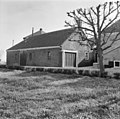 Schuur - Abcoude - 20004235 - RCE.jpg 1,200 × 1,188; 378 KB
-
 Voorgevel - Abcoude - 20004233 - RCE.jpg 1,200 × 1,188; 350 KB


