Category:Durupınar Site
Jump to navigation
Jump to search
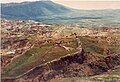
large aggregate structure in Doğubayazıt, Ağrı, Turkey .jpg) A place called Durupınar - a ridge in the shape of a hull (a creature resembling Noah's ark) called after Turkish Air Force Captain İlhan Durupınar, who identified this unit for the first time in an aerial photograph in the territorial mapping project for NATO in 1959 | |||||
| Upload media | |||||
| Instance of | |||||
|---|---|---|---|---|---|
 | |||||
Media in category "Durupınar Site"
The following 11 files are in this category, out of 11 total.
-
 04400 Üzengili-Doğubayazıt-Ağrı, Turkey - panoramio (3).jpg 2,048 × 1,148; 429 KB
-
 04400 Üzengili-Doğubayazıt-Ağrı, Turkey - panoramio.jpg 2,048 × 1,148; 308 KB
-
 Ark structure.jpg 875 × 595; 274 KB
-
 DrogueStoneFasold.jpg 743 × 1,013; 919 KB
-
 NuhunGemisi.jpg 1,792 × 1,200; 1.27 MB
-
 The Durupinar site in July 2019.jpg 3,264 × 2,448; 2.57 MB
-
-
 Turecko Noemova archa (01).jpg 3,872 × 2,592; 4.82 MB
-
 Turecko Noemova archa (02).jpg 3,872 × 2,592; 6.17 MB
-
 Turecko Noemova archa (03).jpg 3,872 × 2,592; 5.26 MB
-
 Turecko Noemova archa (04).jpg 3,872 × 2,592; 3.92 MB
.jpg)


.jpg)
.jpg)
.jpg)