Category:Duns (civil parish)
Jump to navigation
Jump to search
Scottish parish in Scottish Borders, Scotland, UK | |||||
| Upload media | |||||
| Instance of | |||||
|---|---|---|---|---|---|
| Part of |
| ||||
| Named after | |||||
| Location |
| ||||
| Population |
| ||||
| Area |
| ||||
 | |||||
Subcategories
This category has the following 4 subcategories, out of 4 total.
Media in category "Duns (civil parish)"
The following 200 files are in this category, out of 555 total.
(previous page) (next page)-

-
 A barley field at Cockburn - geograph.org.uk - 2035688.jpg 640 × 427; 131 KB
-
 A collapsed drystane dyke - geograph.org.uk - 3814457.jpg 640 × 480; 191 KB
-
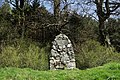 A commemorative cairn on Duns Law - geograph.org.uk - 1270094.jpg 640 × 427; 133 KB
-

-
 A Duns Paths Route signpost - geograph.org.uk - 2035619.jpg 640 × 427; 131 KB
-
 A field corner near Edin's Hall - geograph.org.uk - 2993485.jpg 800 × 533; 126 KB
-
 A grazing field at Duns Law - geograph.org.uk - 6008654.jpg 1,024 × 686; 658 KB
-
 A house called "The Geans" - geograph.org.uk - 2160178.jpg 800 × 600; 203 KB
-
 A newly ploughed field - geograph.org.uk - 3347587.jpg 640 × 480; 259 KB
-
 A Path through the Woods at Duns Castle Estate - geograph.org.uk - 6181213.jpg 4,592 × 3,448; 5.71 MB
-
-
 A signpost to Edin’s Hall Broch - geograph.org.uk - 3814452.jpg 640 × 512; 152 KB
-
 A Southern Upland Way signpost - geograph.org.uk - 2015775.jpg 427 × 640; 133 KB
-
 A survivor by the Whiteadder Water - geograph.org.uk - 3814454.jpg 640 × 500; 170 KB
-
 A track in Duns Castle Nature Reserve - geograph.org.uk - 1270145.jpg 640 × 427; 160 KB
-
 A twisty B6355 towards Chirnside - geograph.org.uk - 5480266.jpg 640 × 480; 86 KB
-
 A6112, Buchansmoor - geograph.org.uk - 3336861.jpg 640 × 360; 223 KB
-
 Abbey Hill (Inner) - geograph.org.uk - 960610.jpg 640 × 480; 85 KB
-
 An ash tree at Duns Law - geograph.org.uk - 3220310.jpg 617 × 535; 230 KB
-
 An old combine at Windy Windyshiel - geograph.org.uk - 2019642.jpg 640 × 427; 148 KB
-
 An old combine part at Windy Windshiel - geograph.org.uk - 2019652.jpg 640 × 427; 142 KB
-

-
 Another Gatehouse leading to Duns Castle - geograph.org.uk - 5440069.jpg 2,048 × 1,536; 1.2 MB
-
 Approaching Cockburn Mill Ford on B6355 - geograph.org.uk - 6226616.jpg 4,538 × 3,360; 5.71 MB
-
 Arable farmland at Duns - geograph.org.uk - 1831565.jpg 640 × 427; 150 KB
-
 Arable field on the edge of Duns - geograph.org.uk - 4184816.jpg 2,048 × 1,536; 1.06 MB
-
 Arable land near Duns - geograph.org.uk - 2606185.jpg 640 × 480; 69 KB
-
 Arable land near Duns - geograph.org.uk - 3336853.jpg 640 × 360; 207 KB
-
 Arable land, Ladywell - geograph.org.uk - 3375004.jpg 640 × 480; 282 KB
-
 At the edge of a barley field - geograph.org.uk - 2035634.jpg 640 × 427; 172 KB
-
 B road through woodland alongside Mill Burn - geograph.org.uk - 6254955.jpg 3,465 × 2,523; 3.99 MB
-
 B6355 - geograph.org.uk - 3831646.jpg 640 × 360; 253 KB
-
 B6355 approaching Millburn Bridge - geograph.org.uk - 5480468.jpg 640 × 480; 136 KB
-
 B6355 crosses Whiteadder near Preston - geograph.org.uk - 5879948.jpg 2,048 × 1,536; 1.41 MB
-
 B6355 towards Chirnside - geograph.org.uk - 5480444.jpg 640 × 480; 89 KB
-
 B6355 towards Chirnside - geograph.org.uk - 5480472.jpg 640 × 480; 76 KB
-
 B6355, Burnhouses - geograph.org.uk - 5480459.jpg 640 × 480; 128 KB
-
 B6355, Windshiel - geograph.org.uk - 5480449.jpg 640 × 480; 83 KB
-
 B6365 near Duns Castle estate - geograph.org.uk - 4045495.jpg 1,024 × 682; 262 KB
-
 B6365 towards Duns - geograph.org.uk - 5480471.jpg 640 × 480; 82 KB
-
 Baramill Plantation - geograph.org.uk - 1033606.jpg 640 × 480; 170 KB
-
 Baramill Plantation - geograph.org.uk - 3636470.jpg 640 × 480; 282 KB
-
 Barn at Windshiel - geograph.org.uk - 2619560.jpg 480 × 640; 81 KB
-
 Barn, Windshiel - geograph.org.uk - 3831642.jpg 640 × 360; 243 KB
-
 Beeches, Lodge Wood - geograph.org.uk - 1033579.jpg 640 × 480; 184 KB
-
 Beeches, Lodge Wood - geograph.org.uk - 3357863.jpg 640 × 480; 328 KB
-
 Berwickshire Brains Walk - geograph.org.uk - 5930103.jpg 1,024 × 683; 584 KB
-
 Berwickshire High School - geograph.org.uk - 1041949.jpg 640 × 480; 65 KB
-
 Berwickshire High School - geograph.org.uk - 1067935.jpg 640 × 480; 69 KB
-
 Berwickshire High School - geograph.org.uk - 2029715.jpg 640 × 480; 59 KB
-
 Berwickshire High School. Duns - geograph.org.uk - 6257619.jpg 4,550 × 3,378; 4.89 MB
-
 Big Louise Plantation - geograph.org.uk - 3479522.jpg 1,775 × 1,255; 861 KB
-
 Big spruce trees, Duns Wood - geograph.org.uk - 5930060.jpg 1,024 × 683; 566 KB
-
 Birds on Hen Poo - geograph.org.uk - 4186085.jpg 2,048 × 1,536; 1.5 MB
-
 Birkenside Burn - geograph.org.uk - 1832926.jpg 640 × 359; 136 KB
-

-
 Black Hill - geograph.org.uk - 1827859.jpg 640 × 480; 73 KB
-
 Black Hill power station. - geograph.org.uk - 2025992.jpg 640 × 480; 75 KB
-
 Black Hill Wind Farm - geograph.org.uk - 2827738.jpg 640 × 387; 186 KB
-
 Black Hill Wind Farm - geograph.org.uk - 6011661.jpg 1,024 × 683; 478 KB
-
 Black Hill wind farm from Commonside - geograph.org.uk - 2586659.jpg 800 × 530; 155 KB
-
 Blawearie Wood, Duns - geograph.org.uk - 6340796.jpg 1,024 × 683; 378 KB
-
 Borthwick Plantation - geograph.org.uk - 4139592.jpg 640 × 480; 323 KB
-
 Bridge over Langton Burn - geograph.org.uk - 5427578.jpg 640 × 480; 80 KB
-
 Bridge over the Mill Burn - geograph.org.uk - 2588544.jpg 800 × 530; 234 KB
-
 Bridgend, Duns - geograph.org.uk - 4175544.jpg 2,048 × 1,536; 1.56 MB
-
 Buchansmoor Plantation - geograph.org.uk - 3336857.jpg 640 × 360; 247 KB
-
 Burnhouses Roundel - geograph.org.uk - 1843629.jpg 640 × 480; 93 KB
-
 Buxley, Manderston Estate - geograph.org.uk - 5305305.jpg 1,024 × 678; 215 KB
-
 Cairn memorial to John Duns Scotus - geograph.org.uk - 6213338.jpg 1,600 × 1,280; 446 KB
-
 Cairnhill Cottages - geograph.org.uk - 5427571.jpg 640 × 480; 63 KB
-
 Car park, Duns Wood - geograph.org.uk - 5929362.jpg 1,024 × 683; 572 KB
-
 Cars on display, Jim Clark Motorsport Museum, Duns - geograph.org.uk - 6231039.jpg 1,600 × 1,060; 392 KB
-
 Castle Street entrance into Duns Castle grounds - geograph.org.uk - 6257482.jpg 4,608 × 3,456; 7.23 MB
-
 Cattle at Hen Poo, Duns Castle estate - geograph.org.uk - 4045543.jpg 1,024 × 714; 215 KB
-
 Cattle drinker on Duns Law - geograph.org.uk - 6213317.jpg 1,600 × 1,009; 381 KB
-
 Cattle grid with hedgehog escape ramp - geograph.org.uk - 3584128.jpg 3,264 × 2,448; 4.37 MB
-
 Cattle near Whitchester Lodge - geograph.org.uk - 5480263.jpg 640 × 480; 85 KB
-
 Clear felled area - geograph.org.uk - 5929400.jpg 1,024 × 683; 354 KB
-
 Clear felled area, Duns Wood - geograph.org.uk - 5930056.jpg 1,024 × 683; 466 KB
-
 Clearing, Duns Castle Wood - geograph.org.uk - 5930063.jpg 1,024 × 683; 451 KB
-
 Clump of trees, Berwickshire High School - geograph.org.uk - 3381953.jpg 640 × 360; 176 KB
-
 Cockburn Dean - geograph.org.uk - 1767368.jpg 359 × 640; 130 KB
-
 Cockburn East - geograph.org.uk - 2055917.jpg 640 × 480; 106 KB
-
 Cockburn Law - geograph.org.uk - 2055926.jpg 640 × 480; 102 KB
-
 Cockburn Law - geograph.org.uk - 960862.jpg 640 × 359; 75 KB
-
 Cockburn Law Summit - geograph.org.uk - 1173744.jpg 640 × 360; 45 KB
-
 Cockburn Law, summit - geograph.org.uk - 960869.jpg 640 × 359; 82 KB
-
 Cockburn Mill Ford - geograph.org.uk - 2029241.jpg 640 × 427; 139 KB
-
 Cockburn Mill Ford - geograph.org.uk - 4005519.jpg 1,600 × 1,200; 633 KB
-
 Cockburn Mill Ford - geograph.org.uk - 5185847.jpg 4,000 × 3,000; 4.25 MB
-
 Cockburn Mill ford and bridge - geograph.org.uk - 2550595.jpg 2,592 × 1,944; 2.7 MB
-
 Cockburn Mill Ford over Whiteadder Water - geograph.org.uk - 6226618.jpg 3,832 × 2,872; 4.79 MB
-
 Concrete road - geograph.org.uk - 2029258.jpg 640 × 480; 102 KB
-
 Concrete road, Knock - geograph.org.uk - 2029245.jpg 640 × 480; 73 KB
-
 Cottage by the lake, Manderston House - geograph.org.uk - 2074710.jpg 640 × 480; 112 KB
-
 Covenanters' Stone, Duns Law - geograph.org.uk - 4186026.jpg 1,536 × 2,048; 1.21 MB
-
 Cow drinking from Hen Poo - geograph.org.uk - 4186079.jpg 2,048 × 1,536; 1.62 MB
-
 Cultivating near Grueldykes - geograph.org.uk - 4176819.jpg 2,048 × 1,536; 1.02 MB
-
 Curious rock formation, Oatleycleugh - geograph.org.uk - 2588478.jpg 800 × 530; 218 KB
-
 Dam, Hen Poo - geograph.org.uk - 5929374.jpg 1,024 × 683; 580 KB
-
 Derelict cottages at Oxendean Tower - geograph.org.uk - 4044675.jpg 1,024 × 682; 220 KB
-
 Drainage, Broomhouse Mains - geograph.org.uk - 1829188.jpg 640 × 480; 166 KB
-
 Duns - Gifford Road - geograph.org.uk - 1033626.jpg 640 × 480; 108 KB
-
 Duns Castle - geograph.org.uk - 5440066.jpg 2,048 × 1,536; 1.38 MB
-
 Duns Castle - geograph.org.uk - 5885845.jpg 2,048 × 1,536; 869 KB
-
 Duns Castle - geograph.org.uk - 5886985.jpg 2,048 × 1,536; 845 KB
-
 Duns Castle - geograph.org.uk - 6212202.jpg 1,200 × 1,179; 293 KB
-
 Duns Castle - geograph.org.uk - 6257609.jpg 4,570 × 3,406; 6.06 MB
-
 Duns Castle in Berwickshire - geograph.org.uk - 5887002.jpg 2,048 × 1,536; 913 KB
-
 Duns Castle Nature Reserve - geograph.org.uk - 1270126.jpg 640 × 427; 143 KB
-
 Duns Cemetery on Preston Road. Arable fields beyond - geograph.org.uk - 6257449.jpg 4,556 × 3,386; 6.02 MB
-
 Duns Cemetery on Preston Road. Duns - geograph.org.uk - 6257443.jpg 4,608 × 3,456; 6.05 MB
-
 Duns Common summit - geograph.org.uk - 6340806.jpg 1,024 × 683; 286 KB
-
 Duns Fire Station - geograph.org.uk - 4184829.jpg 2,048 × 1,536; 1.32 MB
-
 Duns Fire Station - geograph.org.uk - 6257639.jpg 4,608 × 3,456; 7.31 MB
-
 Duns from Duns Law view spot - geograph.org.uk - 4796995.jpg 8,434 × 3,415; 1.96 MB
-
 Duns Golf Clubhouse - geograph.org.uk - 840136.jpg 640 × 480; 102 KB
-
 Duns Golf Course - geograph.org.uk - 943778.jpg 640 × 427; 117 KB
-
 Duns Law - geograph.org.uk - 905377.jpg 640 × 480; 96 KB
-
 Duns Livery sign - geograph.org.uk - 1822618.jpg 640 × 430; 126 KB
-
 Duns Mill - geograph.org.uk - 4184808.jpg 2,048 × 1,152; 748 KB
-
 Duns Police Station. Newtown Street - geograph.org.uk - 6257645.jpg 3,761 × 2,758; 3.34 MB
-
 Duns Rugby Club - geograph.org.uk - 3651139.jpg 640 × 480; 221 KB
-
 Duns Scotus Memorial - geograph.org.uk - 4109651.jpg 480 × 640; 114 KB
-
 Duns Summer Festival - geograph.org.uk - 6213252.jpg 1,600 × 984; 358 KB
-
 Duns War Memorial - geograph.org.uk - 1008558.jpg 480 × 640; 109 KB
-
 Duns War Memorial - geograph.org.uk - 4109654.jpg 480 × 640; 99 KB
-
 Duns Wood - geograph.org.uk - 3651252.jpg 640 × 480; 367 KB
-
 Duns Wood - geograph.org.uk - 5929378.jpg 1,024 × 683; 548 KB
-
 Duns Wood - geograph.org.uk - 6340786.jpg 1,024 × 683; 373 KB
-
 Duns Wood - geograph.org.uk - 6340798.jpg 1,024 × 755; 485 KB
-
 Duns Wood on Duns Common - geograph.org.uk - 5184978.jpg 4,000 × 3,000; 3.17 MB
-
 Edge of the woodland at Commonside - geograph.org.uk - 2586649.jpg 800 × 530; 155 KB
-
 Edge of Young Jeanie's Wood - geograph.org.uk - 2029707.jpg 640 × 480; 121 KB
-
 Edin's Hall Broch - geograph.org.uk - 3096321.jpg 756 × 768; 118 KB
-
 Edin's Hall hillfort - geograph.org.uk - 3096326.jpg 3,264 × 2,448; 4.96 MB
-
 Edin's Hall hillfort - geograph.org.uk - 3096339.jpg 3,264 × 2,448; 5.46 MB
-
 Edin's Hall information panel - geograph.org.uk - 3096262.jpg 1,024 × 717; 120 KB
-
 Edin’s Hall Broch - geograph.org.uk - 3814459.jpg 640 × 465; 175 KB
-
 Eggs for sale, Gateside - geograph.org.uk - 4044666.jpg 1,024 × 738; 307 KB
-
 Elba - geograph.org.uk - 2055934.jpg 640 × 480; 90 KB
-
 Elba footbridge - geograph.org.uk - 2993548.jpg 533 × 800; 217 KB
-
 Elba Footbridge - geograph.org.uk - 3814445.jpg 458 × 640; 174 KB
-
 Elba Footbridge - geograph.org.uk - 6213425.jpg 1,200 × 1,610; 523 KB
-
 Elba footbridge from the west - geograph.org.uk - 2993526.jpg 800 × 533; 227 KB
-
 Elba Footbridge from the west - geograph.org.uk - 6213429.jpg 1,600 × 1,064; 445 KB
-
 Ellerburn Wood - geograph.org.uk - 6211741.jpg 1,600 × 1,035; 186 KB
-
 Elphole Plantation - geograph.org.uk - 1829183.jpg 640 × 480; 177 KB
-
 Entering Burnhouses on the B6355 - geograph.org.uk - 6257719.jpg 4,290 × 2,974; 5.05 MB
-
 Entrance to Duns - geograph.org.uk - 2685266.jpg 640 × 480; 34 KB
-
 Entrance to Duns Public Park - geograph.org.uk - 4175546.jpg 2,048 × 1,152; 1.04 MB
-
 Entrance to industrial units - geograph.org.uk - 1458653.jpg 640 × 480; 67 KB
-
 Estate Road, Duns Castle - geograph.org.uk - 4186100.jpg 2,048 × 1,536; 1.14 MB
-
 Estate walls at Wedderburn - geograph.org.uk - 862546.jpg 640 × 480; 78 KB
-
 Farm buildings at Langton Mill - geograph.org.uk - 4176825.jpg 2,048 × 1,152; 737 KB
-
 Farm buildings at Windshiel - geograph.org.uk - 1565944.jpg 640 × 413; 134 KB
-
 Farm road near Manderston - geograph.org.uk - 1165367.jpg 640 × 480; 50 KB
-
 Farm track above Kidshielhaugh - geograph.org.uk - 2029703.jpg 640 × 480; 118 KB
-
 Farmland above Manderston Mill - geograph.org.uk - 5304682.jpg 1,024 × 678; 209 KB
-
 Farmland at Cockburn - geograph.org.uk - 2029248.jpg 640 × 427; 126 KB
-
 Farmland at Cockburn Law - geograph.org.uk - 2035678.jpg 640 × 427; 133 KB
-
 Feeding the ducks - geograph.org.uk - 5628981.jpg 1,024 × 683; 821 KB
-
 Felled plantation, Langtonlees - geograph.org.uk - 1764849.jpg 640 × 480; 117 KB
-
 Field corner, Knock - geograph.org.uk - 1843632.jpg 640 × 480; 145 KB
-
 Field margin and ripening crop - Wedderburn - geograph.org.uk - 4633448.jpg 3,648 × 2,736; 4.34 MB
-
 Field near Duns - geograph.org.uk - 5930159.jpg 1,024 × 576; 343 KB
-
 Field of barley, Knock - geograph.org.uk - 2588631.jpg 800 × 530; 155 KB
-
 Field, Burnhouses - geograph.org.uk - 3831649.jpg 640 × 360; 265 KB
-
 Field, Cairnhills - geograph.org.uk - 5427570.jpg 640 × 480; 43 KB
-
 Field-side track at Oxendean - geograph.org.uk - 5184996.jpg 4,000 × 3,000; 5.43 MB
-
 Fields around Burnhouses - geograph.org.uk - 2587857.jpg 800 × 530; 166 KB
-
 Fields outside Duns - geograph.org.uk - 1033632.jpg 640 × 480; 101 KB
-
 Fire beaters, Hen Toe Wood - geograph.org.uk - 2619538.jpg 480 × 640; 66 KB
-
 Flood damage, Mill Burn - geograph.org.uk - 2029230.jpg 480 × 640; 162 KB
-
 Flooded field, Elba - geograph.org.uk - 1730248.jpg 640 × 359; 69 KB
-
 Footbridge, Plendernethy Burn - geograph.org.uk - 2588662.jpg 800 × 530; 222 KB
-
 Footpath along disused railway at Duns - geograph.org.uk - 4633424.jpg 1,600 × 1,200; 599 KB
-
 Footpath Sign and Old Mill Buildings - Broomhouse - geograph.org.uk - 2314758.jpg 2,736 × 3,648; 3.14 MB
-
 Footpath sign, Johnsfield - geograph.org.uk - 3347603.jpg 640 × 480; 246 KB
-

-
 Ford at Elba - geograph.org.uk - 2993540.jpg 800 × 533; 192 KB
-
 Ford on field track. Kidcleugh Burn - geograph.org.uk - 6257884.jpg 4,000 × 3,000; 5.26 MB
-
 Forest ride, Hen Toe Burn Wood - geograph.org.uk - 2587778.jpg 800 × 530; 208 KB
-

-
 Former boundary, Duns Wood - geograph.org.uk - 5930054.jpg 1,024 × 683; 579 KB
-
 Former High School now Duns Primary School - geograph.org.uk - 6257628.jpg 4,608 × 3,456; 3.01 MB
-
 Former RBS bank, Duns - geograph.org.uk - 6231079.jpg 1,600 × 1,060; 294 KB
-

-
 Frost by Johnsfield - geograph.org.uk - 3347612.jpg 640 × 480; 286 KB
-
 Frost, Cumledge - geograph.org.uk - 3347579.jpg 640 × 480; 270 KB
-
 Gardener's Cottage at Buxley - geograph.org.uk - 4630538.jpg 1,200 × 1,600; 560 KB
-
 Gate by Edin's Hall - geograph.org.uk - 1726049.jpg 640 × 359; 62 KB
-
 Gate House in Duns Castle Estate - geograph.org.uk - 5401149.jpg 2,048 × 1,536; 1.15 MB
-
 Gate, Edin's Hall - geograph.org.uk - 1726054.jpg 640 × 480; 90 KB
-
 Gateway to Duns Castle - geograph.org.uk - 6213325.jpg 1,600 × 1,046; 314 KB
-
 Grass field, Oatleycleugh - geograph.org.uk - 1767373.jpg 640 × 480; 106 KB
-
 Grassland and strip wood - geograph.org.uk - 1843639.jpg 640 × 480; 94 KB
-
 Grassland towards Cockburn Dean - geograph.org.uk - 5480454.jpg 640 × 480; 73 KB


_-_geograph.org.uk_-_960610.jpg)


&filefrom=Grassland%2C+Cockburn+Law+-+geograph.org.uk+-+960855.jpg#mw-category-media)