Category:Drainage basin maps of France
Jump to navigation
Jump to search
Countries of Europe: Armenia‡ · Azerbaijan‡ · Bosnia and Herzegovina · Czech Republic · Finland · France‡ · Georgia‡ · Germany · Italy · Latvia · Lithuania · Norway · Poland · Portugal‡ · Romania · Slovakia · Spain‡ · Sweden · Switzerland · Turkey‡ · Ukraine · United Kingdom
‡: partly located in Europe
‡: partly located in Europe
Media in category "Drainage basin maps of France"
The following 58 files are in this category, out of 58 total.
-
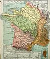 France-hydrogr.JPG 1,851 × 2,196; 1.28 MB
-
 07-Bassins-versants.jpg 3,507 × 2,480; 458 KB
-
 11-Bassins-versants.jpg 3,507 × 2,480; 543 KB
-
 22-Bassins-versants.jpg 3,507 × 2,480; 588 KB
-

-
 28-Bassins-versants.jpg 3,507 × 2,480; 483 KB
-
 29-Bassins-versants.jpg 3,507 × 2,480; 596 KB
-
 71-Bassins-versants.jpg 3,507 × 2,480; 520 KB
-
 72-Bassins-versants.jpg 3,507 × 2,480; 431 KB
-
 72-SAGE.jpg 3,507 × 2,480; 500 KB
-
 85-Bassins-versants.jpg 3,507 × 2,480; 463 KB
-
 86-Bassins-versants.jpg 3,507 × 2,480; 523 KB
-
 87-Bassins-versants.jpg 3,507 × 2,480; 541 KB
-
 Affluents de la rivière Ellé carte.jpg 2,062 × 2,398; 215 KB
-
 Arques drainage basin-fr.svg 2,258 × 1,975; 2 MB
-
 Bassin Seine.png 3,500 × 3,007; 6.72 MB
-
 Bassin versant de la Bresle.jpg 1,340 × 938; 192 KB
-
 Bresle Drainage Basin-fr.svg 1,024 × 717; 308 KB
-
 Carte Bassin Versant de l Yerres.svg 1,177 × 718; 12.03 MB
-
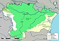
 Drainage Basins France.png 2,138 × 1,794; 1.44 MB
-
 France drainage basins mk.svg 2,000 × 1,898; 802 KB
-
 France drainage basins-es.svg 2,133 × 2,025; 893 KB
-
 France drainage basins.svg 2,000 × 1,898; 728 KB
-
 FranceWater.JPG 868 × 855; 91 KB
-
 Carte topographique du bassin du Grand Morin (France).svg 1,099 × 683; 3.94 MB
-
 Grands lacs de Seine.png 863 × 745; 672 KB
-
 La Loire et ses affluents.jpg 1,099 × 1,000; 329 KB
-
 Laita carte.jpg 2,349 × 2,986; 607 KB
-
 Loire river tribs map.png 1,099 × 1,000; 1.23 MB
-
 Marne bassin.jpg 1,483 × 848; 418 KB
-
 Oust River Drainage Basin map-fr.svg 1,954 × 1,573; 817 KB
-
 RBD-France.svg 1,913 × 1,906; 13.79 MB
-
 RBD-FRance.svg 1,913 × 1,906; 8.8 MB
-
 Flusssystemkarte Rhein 01.svg 861 × 1,186; 7.81 MB
-
 Flusssystemkarte Rhein 02.jpg 3,197 × 4,342; 11.75 MB
-
 Rhone bacino idrografico.png 838 × 1,175; 1.25 MB
-
 Rhone bassin versant.png 838 × 1,175; 1.23 MB
-
 Rhone drainage basin.png 838 × 1,175; 1.24 MB
-
 Rhone Einzugsgebiet.png 838 × 1,175; 1.24 MB
-
 Rivière Aven.jpg 2,484 × 3,496; 561 KB
-
 Scorff03.jpg 3,333 × 5,588; 1.46 MB
-
 Topographic map of the Seine basin (French - png).png 3,827 × 3,284; 8.34 MB
-
 Seine bassin versant.png 974 × 792; 865 KB
-
 Seine drainage basin.png 974 × 792; 866 KB
-
 Seine Einzugsgebiet.png 974 × 792; 866 KB
-
 Bassin de la Somme.svg 1,464 × 948; 3.42 MB
-
 Topographic map of the Seine basin (English png).png 3,484 × 2,987; 7.64 MB
-
 Topographic map of the Seine basin (English).svg 1,155 × 992; 5.39 MB
-
 Topographic map of the Seine basin (Esperanto).svg 1,155 × 992; 5.4 MB
-
 Topographic map of the Seine basin (Esperanto- png).png 3,477 × 2,987; 7.67 MB
-
 Topographic map of the Seine basin (French png).png 3,500 × 3,007; 7.71 MB
-
 Topographic map of the Seine basin es.svg 1,155 × 992; 5.49 MB
-
 Topographic map of the Seine basin.svg 1,155 × 992; 5.2 MB
-
 Drainage basin map of Touch.jpg 1,842 × 1,379; 166 KB
-
 Vilaine River Drainage Basin map-br.svg 1,954 × 1,573; 805 KB
-
 Vilaine River Drainage Basin map-fr.svg 1,954 × 1,573; 799 KB
-
 Vilaine River Drainage Basin map-mk.svg 1,954 × 1,573; 1.1 MB
-
 Cartographie bassin versant Yerres.svg 1,015 × 602; 13.57 MB


.jpg)


.svg)


.png)


.png)
.svg)
.svg)
.png)
.png)


