Category:Drängsereds kyrka
Jump to navigation
Jump to search
| Object location | | View all coordinates using: OpenStreetMap |
|---|
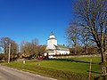
church building in Hylte Municipality, Halland County, Sweden  | |||||
| Upload media | |||||
| Instance of | |||||
|---|---|---|---|---|---|
| Location | Hylte Municipality, Halland County, Sweden | ||||
| Diocese | |||||
| Connects with |
| ||||
| Has use |
| ||||
| Occupant |
| ||||
| Heritage designation |
| ||||
 | |||||
Svenska: Drängsereds kyrka tillhör Drängsereds församling, Torups pastorat, Falkenbergs kontrakt, Göteborgs stift / Diocese of Gothenburg.
|
This is a category about an ecclesiastical monument in Sweden, number 21300000003603 in the RAÄ buildings database.
|
Media in category "Drängsereds kyrka"
The following 24 files are in this category, out of 24 total.
-
 Drängsered, kyrka 5.jpg 4,032 × 3,024; 6.05 MB
-
 Drängsereds kyrka - KMB - 16000200032951.jpg 416 × 600; 46 KB
-
 Drängsereds kyrka - KMB - 16000200032972.jpg 413 × 600; 66 KB
-
 Drängsereds kyrka - KMB - 16000200032976.jpg 800 × 526; 145 KB
-
 Drängsereds kyrka - KMB - 16000200032977.jpg 800 × 530; 107 KB
-
 Drängsereds kyrka - KMB - 16000200032979.jpg 800 × 523; 134 KB
-
 Drängsereds kyrka - KMB - 16000200032980.jpg 800 × 547; 62 KB
-
 Drängsereds kyrka - KMB - 16000200032983.jpg 403 × 600; 46 KB
-
 Drängsereds kyrka - KMB - 16000200032990.jpg 419 × 600; 53 KB
-
 Drängsereds kyrka - KMB - 16000200032992.jpg 415 × 600; 66 KB
-
 Drängsereds kyrka - KMB - 16000200032993.jpg 435 × 600; 64 KB
-
 Drängsereds kyrka - KMB - 16000200032994.jpg 405 × 600; 41 KB
-
 Drängsereds kyrka - KMB - 16000200032996.jpg 414 × 600; 44 KB
-
 Drängsereds kyrka - KMB - 16000200032997.jpg 415 × 600; 42 KB
-
 Drängsereds kyrka - KMB - 16000200032998.jpg 423 × 600; 45 KB
-
 Drängsereds kyrka old1.jpg 800 × 547; 77 KB
-
 Drängsereds kyrka old2.jpg 800 × 530; 135 KB
-
 Drängsereds kyrka Sophia Magdalena kyrka.jpg 4,928 × 3,264; 1.33 MB
-
 Kyrka, Drängsered 3.jpg 4,032 × 3,024; 3.86 MB
-
 Kyrka, Drängsered, 2.jpg 4,032 × 3,024; 5.1 MB
-
 Kyrka, Drängsered, 4.jpg 4,032 × 3,024; 4.84 MB
-
 Kyrka, Drängsered, gavel.jpg 3,024 × 4,032; 5.44 MB
-
 Kyrka, Drängsered, kyrkogård.jpg 4,032 × 3,024; 5.72 MB
-
 Kyrka, Drängsered.jpg 4,032 × 3,024; 4.44 MB


Categories:
- Built in Hylte Municipality in 1785
- Churches in the Diocese of Gothenburg
- Churches in Hylte Municipality
- Churches in Halland
- Churches in Sweden built in 1785
- 1780s churches in Halland County
- Drängsered
- Listed churches in Hylte Municipality
- Neoclassical churches in Halland County
- Stone churches in Halland County
- White churches in Sweden
- Mansards in Sweden