Category:Dorpskerk, Olst
Jump to navigation
Jump to search
| Object location | | View all coordinates using: OpenStreetMap |
|---|
church building in Olst, Netherlands  | |||||
| Upload media | |||||
| Instance of | |||||
|---|---|---|---|---|---|
| Location | Olst, Overijssel, Netherlands | ||||
| Street address |
| ||||
| Located on street |
| ||||
| Architect | |||||
| Heritage designation |
| ||||
| Inception |
| ||||
 | |||||
Kerk:
|
This is a category about rijksmonument number 31437
|
Toren:
|
This is a category about rijksmonument number 31438
|
| Address |
|
Subcategories
This category has only the following subcategory.
Media in category "Dorpskerk, Olst"
The following 28 files are in this category, out of 28 total.
-
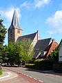 20150706 Hervormde Kerk Olst.jpg 3,672 × 4,896; 1.4 MB
-
 20150716 Zicht op Olst vanaf de Tichelstraat bij Den Nul.jpg 4,875 × 1,438; 1.66 MB
-
 Exterieur details - Olst - 20172989 - RCE.jpg 1,200 × 809; 309 KB
-
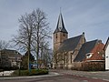
 Exterieur naar het noord-westen - Olst - 20172983 - RCE.jpg 1,200 × 960; 401 KB
-
 Exterieur overzicht naar het zuid-westen - Olst - 20172982 - RCE.jpg 960 × 1,200; 352 KB
-
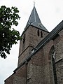
 Exterieur TOREN, WESTGEVEL, INGANGSPARTIJ - Olst - 20268090 - RCE.jpg 1,195 × 1,200; 446 KB
-
 Exterieur ZUIDGEVEL, KOOR, TEKSTSTEEN - Olst - 20268091 - RCE.jpg 1,190 × 1,200; 503 KB
-
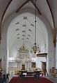
 Interieur naar het oosten - Olst - 20172985 - RCE.jpg 954 × 1,200; 179 KB
-
 Interieur naar het westen - Olst - 20172984 - RCE.jpg 952 × 1,200; 194 KB
-
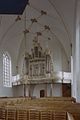
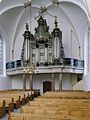 Interieur, aanzicht orgel,orgelnummer 1129 - Olst - 20417267 - RCE.jpg 897 × 1,200; 196 KB
-
 Interieur, koor, gewelfschildering, detail - Olst - 20328926 - RCE.jpg 1,194 × 1,200; 162 KB
-
 Interieur, koor, gewelfschildering, detail - Olst - 20328927 - RCE.jpg 1,196 × 1,200; 193 KB
-
 Interieur, koor, gewelfschildering, detail - Olst - 20328928 - RCE.jpg 1,200 × 1,198; 184 KB
-
 Interieur, koor, gewelfschilderingen - Olst - 20328924 - RCE.jpg 1,187 × 1,200; 256 KB
-
 Interieur, overzicht naar het oosten - Olst - 20328923 - RCE.jpg 802 × 1,200; 122 KB
-
 Interieur, overzicht naar het westen - Olst - 20328921 - RCE.jpg 817 × 1,200; 131 KB
-
 Interieur, schip, gewelfschilderingen - Olst - 20328925 - RCE.jpg 1,200 × 1,194; 251 KB
-
 Kerk vanuit het zuiden - Olst - 20172981 - RCE.jpg 912 × 1,200; 374 KB
-
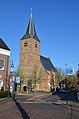 Nederlands Hervormde Kerk church Olst 2019.jpg 3,264 × 4,928; 7.04 MB
-
 Olst kerk.jpg 2,304 × 3,072; 1.42 MB
-
 Olst, de Nederlands Hervormde kerk RM31437 IMG 2011 2018-04-07 11.26.jpg 4,715 × 3,542; 10.24 MB
-
 Orgel - Olst - 20328922 - RCE.jpg 800 × 1,200; 126 KB
-

-
 Overzicht zuidoostgevel met kerktoren - Olst - 20351119 - RCE.jpg 956 × 1,200; 231 KB
-
 Protestant church of Olst in the center of the village - panoramio.jpg 4,288 × 2,848; 3.02 MB
-
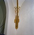
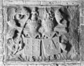 Reliëf in torenportaal - Olst - 20172986 - RCE.jpg 1,200 × 954; 370 KB
-
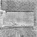
 Restant steunbeer toren - Olst - 20172994 - RCE.jpg 794 × 1,200; 225 KB
-
 Restauratie van doopvont aan de noord-oost zijde van de Kerk - Olst - 20172987 - RCE.jpg 1,200 × 1,180; 437 KB


