Category:Dorfkirche Schöpfurth
Jump to navigation
Jump to search
| Object location | | View all coordinates using: OpenStreetMap |
|---|
church building in Brandenburg  | |||||
| Upload media | |||||
| Instance of |
| ||||
|---|---|---|---|---|---|
| Location | Finowfurt, Schorfheide, Barnim District, Brandenburg, Germany | ||||
| Street address |
| ||||
| Heritage designation | |||||
| Inception |
| ||||
 | |||||
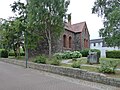
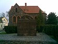
This is the category of the Brandenburger Baudenkmal (cultural heritage monument) with the ID 09175670 (Wikidata)
|
English: Pictures of the church Schöpfurth in Finowfurt, Schorfheide municipality, Barnim district, Brandenburg state, Germany.
Deutsch: Ansichten der Kirche Schöpfurth in Finowfurt, Gemeinde Schorfheide, Landkreis Barnim, Land Brandenburg, Deutschland.
Français : Photos de l'église Schöpfurth à Finowfurt, commune de Schorfheide, arrondissement de Barnim, état fédéral de Brandebourg, Allemagne
Español: Vistas de la iglesia Schöpfurth en Finowfurt, municipio de Schorfheide, distrito de Barnim, estado federado de Brandeburgo, Alemania
Address:
Hauptstraße 116a, Finowfurt, 16244 Schorfheide
Pages in category "Dorfkirche Schöpfurth"
This category contains only the following page.
Media in category "Dorfkirche Schöpfurth"
The following 18 files are in this category, out of 18 total.
-
 Dorfkirche Schöpfurth 2023 ENE.jpg 2,560 × 1,920; 2.12 MB
-
 Dorfkirche Schöpfurth 2023 NNE.jpg 4,032 × 3,024; 4.65 MB
-
 Dorfkirche Schöpfurth 2023 Nordfenster.jpg 1,760 × 2,266; 1.04 MB
-
 Dorfkirche Schöpfurth 2023 NW.jpg 2,560 × 1,920; 2.1 MB
-
 Dorfkirche Schöpfurth 2023 S.jpg 1,869 × 2,336; 1.08 MB
-
 Dorfkirche Schöpfurth 2023 SW.jpg 2,560 × 1,920; 2.06 MB
-
 Dorfkirche Schöpfurth 2023 Westportal.jpg 1,817 × 2,422; 1.23 MB
-
 Finowfurt - zabytkowy, kamienny budynek ( chyba kościół ) - panoramio.jpg 4,000 × 3,000; 6.48 MB
-
 Finowfurt Dorfkirche Schöpfurth 01.JPG 2,816 × 2,112; 2.61 MB
-
 Finowfurt Dorfkirche Schöpfurth 02.JPG 2,816 × 2,112; 2.98 MB
-
 Finowfurt Dorfkirche Schöpfurth 03.JPG 2,184 × 2,032; 2.27 MB
-
 Finowfurt Dorfkirche Schöpfurth 04.JPG 2,112 × 2,816; 3.18 MB
-
 Finowfurt Dorfkirche Schöpfurth 05.JPG 2,816 × 2,112; 3.19 MB
-
 Finowfurt Dorfkirche Schöpfurth 06.JPG 2,112 × 2,816; 3.7 MB
-
 Finowfurt Dorfkirche Schöpfurth 07.JPG 2,112 × 2,816; 3.31 MB
-
 Finowfurt Dorfkirche Schöpfurth 08.JPG 2,816 × 2,112; 3.44 MB
-
 Finowfurt Dorfkirche Schöpfurth 09.JPG 2,816 × 2,112; 2.66 MB
-
 KircheFF2.jpg 1,600 × 1,200; 746 KB


_-_panoramio.jpg)


