Category:Dorfkirche Schöneberg (Uckermark)
Jump to navigation
Jump to search
| Object location | | View all coordinates using: OpenStreetMap |
|---|
church building in Uckermark district, Brandenburg state, Germany  | |||||
| Upload media | |||||
| Instance of | |||||
|---|---|---|---|---|---|
| Location | Schöneberg (Uckermark), Schwedt/Oder, Uckermark District, Brandenburg, Germany | ||||
| Heritage designation | |||||
 | |||||
This is the category of the Brandenburger Baudenkmal (cultural heritage monument) with the ID 09130618 (Wikidata)
|
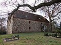
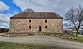
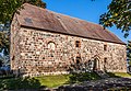
English: Pictures of the former church in Schöneberg, Schwedt municipality, Uckermark district, Brandenburg state, Germany.
Deutsch: Ansichten der früheren Kirche in Schöneberg, Stadt Schwedt, Landkreis Uckermark, Land Brandenburg, Deutschland.
Français : Photos de l'ancienne église à Schöneberg, ville de Schwedt, arrondissement de Uckermark, état fédéral de Brandebourg, Allemagne
Español: Vistas de la antigua iglesia en Schöneberg, ciudad de Schwedt, distrito de Uckermark, estado federado de Brandeburgo, Alemania
Address:
Zum Springsee 9, 16278 Schöneberg
Media in category "Dorfkirche Schöneberg (Uckermark)"
The following 12 files are in this category, out of 12 total.
-
 Dorfkirche Schöneberg (Uckermark) 2021 E.jpg 3,024 × 4,032; 5.14 MB
-
 Dorfkirche Schöneberg (Uckermark) 2021 NE.jpg 4,864 × 3,648; 8.62 MB
-
 Dorfkirche Schöneberg (Uckermark) 2021 Portal S.jpg 3,648 × 4,864; 7.87 MB
-
 Dorfkirche Schöneberg (Uckermark) 2021 Portal W.jpg 3,538 × 4,782; 8.45 MB
-
 Dorfkirche Schöneberg (Uckermark) 2021 S.jpg 4,529 × 2,690; 5.06 MB
-
 Dorfkirche Schöneberg (Uckermark) 2021 SE.jpg 4,864 × 3,648; 7.76 MB
-
 SchoenebergKirche 10 14 01 jiw.jpg 1,745 × 1,200; 799 KB
-
 SchoenebergKirche 10 14 01.jpg 2,908 × 2,000; 1.8 MB
-
 SchönebergSpeicher.jpg 3,264 × 2,448; 395 KB
-
 SchönebergSpeicherPlade.jpg 2,250 × 1,836; 349 KB
-
 SchönebergSpeicherSkakbrætsten.jpg 3,048 × 2,448; 520 KB
-
 SchönebergSpeicherSkakbrætstenNær.jpg 2,664 × 1,716; 406 KB
_2021_E.jpg)
_2021_NE.jpg)
_2021_Portal_S.jpg)
_2021_Portal_W.jpg)
_2021_S.jpg)
_2021_SE.jpg)


