Category:Dorfkirche Neuhof (Jüterbog)
Jump to navigation
Jump to search
| Object location | | View all coordinates using: OpenStreetMap |
|---|
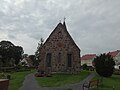
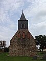
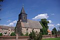
church building in Neuhof, Germany  | |||||
| Upload media | |||||
| Instance of | |||||
|---|---|---|---|---|---|
| Location | Jüterbog, Teltow-Fläming District, Brandenburg, Germany | ||||
| Heritage designation | |||||
 | |||||
This is the category of the Brandenburger Baudenkmal (cultural heritage monument) with the ID 09105446 (Wikidata)
|
Media in category "Dorfkirche Neuhof (Jüterbog)"
The following 10 files are in this category, out of 10 total.
-
 Dorfkirche Neuhof Blick von Norden ins Kirchenschiff.jpg 4,608 × 3,456; 3.88 MB
-
 Dorfkirche Neuhof Blick von Osten ins Kirchenschiff.jpg 4,608 × 3,456; 3.93 MB
-
 Dorfkirche Neuhof Gräberfeld.jpg 4,608 × 3,456; 6.47 MB
-
 Dorfkirche Neuhof Kirchenschiff Südansicht.jpg 4,608 × 3,456; 5.8 MB
-
 Dorfkirche Neuhof Nordwestansicht.jpg 4,608 × 3,456; 3.64 MB
-
 Dorfkirche Neuhof Ostansicht.jpg 4,608 × 3,456; 4.15 MB
-
 Dorfkirche Neuhof Südostansicht.jpg 4,608 × 3,456; 4.86 MB
-
 Dorfkirche Neuhof Westansicht.jpg 3,456 × 4,608; 4.02 MB
-
 Dorfkirche Neuhof Westturm Südansicht.jpg 3,456 × 4,608; 3.97 MB
-
 Kirche Neuhof Jüterbog.jpg 3,872 × 2,592; 1.31 MB


