Category:Dorfkirche Neu Golm
Jump to navigation
Jump to search
| Object location | | View all coordinates using: OpenStreetMap |
|---|
church building in Oder-Spree district, Brandenburg state, Germany  | |||||
| Upload media | |||||
| Instance of | |||||
|---|---|---|---|---|---|
| Location | Neu Golm, Bad Saarow, Oder-Spree District, Brandenburg, Germany | ||||
| Heritage designation | |||||
 | |||||
This is the category of the Brandenburger Baudenkmal (cultural heritage monument) with the ID 09115348 (Wikidata)
|
Media in category "Dorfkirche Neu Golm"
The following 14 files are in this category, out of 14 total.
-
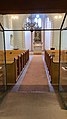 Dorfkirche in Neu Golm, Bad Saarow, Brandenburg-2021-001.56 (1).jpg 900 × 1,600; 175 KB
-
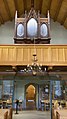 Dorfkirche in Neu Golm, Bad Saarow, Brandenburg-2021-002.56.jpg 900 × 1,600; 175 KB
-
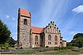 Dorfkirche Neu Golm 1.jpg 6,000 × 4,000; 9.1 MB
-
 Dorfkirche Neu Golm 2.jpg 6,000 × 4,000; 8.56 MB
-
 Dorfkirche Neu Golm Epitaph Otto.jpg 3,024 × 4,032; 4.82 MB
-
 Dorfkirche Neu Golm Epitaph.jpg 3,024 × 4,032; 4.76 MB
-
 Dorfkirche Neu Golm Gedenktafel.jpg 4,000 × 6,000; 13.1 MB
-
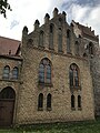 Dorfkirche Neu Golm Nordansicht Querhaus.jpg 3,024 × 4,032; 4.08 MB
-
 Dorfkirche Neu Golm Ostansicht.jpg 4,032 × 3,024; 3.85 MB
-
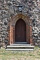 Dorfkirche Neu Golm Portal.jpg 4,000 × 6,000; 12.58 MB
-
 Dorfkirche Neu Golm Südostansicht.jpg 4,032 × 3,024; 3.35 MB
-
 Dorfkirche Neu Golm Westturm Westansicht.jpg 3,024 × 4,032; 2.56 MB
-
 Neu Golm - Dorfkirche - panoramio.jpg 480 × 640; 75 KB
-
 Neu Golm Bad Saarow Kirche.jpg 3,872 × 2,592; 1.13 MB
.jpg)


