Category:Dorfkirche Jühnsdorf
Jump to navigation
Jump to search
| Object location | | View all coordinates using: OpenStreetMap |
|---|
church building in Brandenburg, Germany  | |||||
| Upload media | |||||
| Instance of | |||||
|---|---|---|---|---|---|
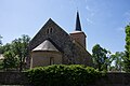
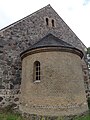
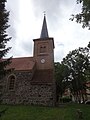
| Location | Jühnsdorf, Blankenfelde-Mahlow, Teltow-Fläming District, Brandenburg, Germany | ||||
| Heritage designation | |||||
 | |||||
This is the category of the Brandenburger Baudenkmal (cultural heritage monument) with the ID 09105068 (Wikidata)
|
Media in category "Dorfkirche Jühnsdorf"
The following 29 files are in this category, out of 29 total.
-
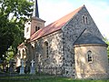 Dorfkirche Jühnsdorf - Deutschland - panoramio.jpg 2,592 × 1,944; 2.58 MB
-
 Dorfkirche Jühnsdorf 2018 01.jpg 6,016 × 4,000; 14.4 MB
-
 Dorfkirche Jühnsdorf 2018 02.jpg 6,016 × 4,000; 16.08 MB
-
 Dorfkirche Jühnsdorf 2018 03.jpg 6,016 × 4,000; 14.31 MB
-
 Dorfkirche Jühnsdorf 2018 04.jpg 6,016 × 4,000; 14.52 MB
-
 Dorfkirche Jühnsdorf 2018 05.jpg 6,016 × 4,000; 12.7 MB
-
 Dorfkirche Jühnsdorf 2018 06.jpg 6,016 × 4,000; 12.81 MB
-
 Dorfkirche Jühnsdorf 2018 07.jpg 6,016 × 4,000; 10 MB
-
 Dorfkirche Jühnsdorf Friedhof Südseite.jpg 4,608 × 3,456; 6.33 MB
-
 Dorfkirche Jühnsdorf Hinweistafel Westturm Nordseite.jpg 4,608 × 3,456; 6.07 MB
-
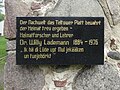 Dorfkirche Jühnsdorf Hinweistafel Westturm Südseite.jpg 4,076 × 3,057; 4.64 MB
-
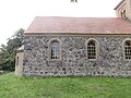 Dorfkirche Jühnsdorf Kirchenschiff Nordseite.jpg 4,608 × 3,456; 5.79 MB
-
 Dorfkirche Jühnsdorf Kirchenschiff Südseite August 2017.jpg 4,608 × 3,456; 6.02 MB
-
 Dorfkirche Jühnsdorf Nordansicht August 2017.jpg 4,608 × 3,456; 4.93 MB
-
 Dorfkirche Jühnsdorf Nordansicht.jpg 4,608 × 3,456; 5.02 MB
-
 Dorfkirche Jühnsdorf Ostansicht.jpg 3,456 × 4,608; 4.65 MB
-
 Dorfkirche Jühnsdorf Südansicht August 2017.jpg 4,608 × 3,456; 5.29 MB
-
 Dorfkirche Jühnsdorf Südansicht.jpg 4,608 × 3,456; 4.6 MB
-
 Dorfkirche Jühnsdorf Südostansicht.jpg 4,608 × 3,456; 4.04 MB
-
 Dorfkirche Jühnsdorf Westturm Nordansicht.jpg 3,456 × 4,608; 4.09 MB
-
 Dorfkirche Jühnsdorf Westturm Südansicht August 2017.jpg 3,456 × 4,608; 4.59 MB
-
 Dorfkirche Jühnsdorf Westturm Turmobergeschoss.jpg 3,456 × 4,608; 3.44 MB
-
 Dorfkirche Jühnsdorf Westturm Turmuntergeschoss.jpg 4,608 × 3,456; 5.44 MB
-
 Dorfkirche Jühnsdorf Westturm Westansicht August 2017.jpg 3,456 × 4,608; 4.46 MB
-
 Dorfkirche Jühnsdorf.jpg 3,025 × 2,933; 2.2 MB
-
 Infotafel an der Kirche in Jühnsdorf - panoramio.jpg 4,320 × 3,240; 5.01 MB
-
 Juehnsdorf church.JPG 643 × 577; 77 KB
-
 Juehnsdorf Knesebeck graves.jpg 1,800 × 1,440; 816 KB
-
 Kirche Jühnsdorf - panoramio.jpg 4,320 × 3,240; 5.18 MB


