Category:Dorfkirche Gottberg (Märkisch Linden)
Jump to navigation
Jump to search
| Object location | | View all coordinates using: OpenStreetMap |
|---|
This is the category of the Brandenburger Baudenkmal (cultural heritage monument) with the ID 09170270 (Wikidata)
|
church building in Brandenburg state, Germany  | |||||
| Upload media | |||||
| Instance of | |||||
|---|---|---|---|---|---|
| Made from material | |||||
| Location | Gottberg (Märkisch Linden), Märkisch Linden, Ostprignitz-Ruppin District, Brandenburg, Germany | ||||
| Street address |
| ||||
| Architectural style | |||||
| Heritage designation | |||||
 | |||||
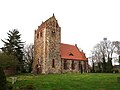
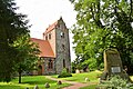
English: Pictures of the church in Gottberg, Märkisch Linden municipality, Ostprignitz-Ruppin district, Brandenburg state, Germany.
Deutsch: Ansichten der Kirche in Gottberg, Gemeinde Märkisch Linden, Landkreis Ostprignitz-Ruppin, Land Brandenburg, Deutschland.
Français : Photos de l'église à Gottberg, commune de Märkisch Linden, arrondissement de Ostprignitz-Ruppin, état fédéral de Brandebourg, Allemagne
Español: Vistas de la iglesia en Gottberg, municipio de Märkisch Linden, distrito de Ostprignitz-Ruppin, estado federado de Brandeburgo, Alemania
Address: Gottberger Dorfstraße 67, Gottberg, 16845 Märkisch Linden
Pages in category "Dorfkirche Gottberg (Märkisch Linden)"
This category contains only the following page.
Media in category "Dorfkirche Gottberg (Märkisch Linden)"
The following 18 files are in this category, out of 18 total.
-
 Dorfkirche Gottberg 2016 N.jpg 3,610 × 2,708; 5.18 MB
-
 Dorfkirche Gottberg 2016 SW.jpg 4,864 × 3,648; 4.65 MB
-
 Dorfkirche Gottberg 2021 E.jpg 3,006 × 4,007; 2.12 MB
-
 Dorfkirche Gottberg 2021 NNE.jpg 4,864 × 3,648; 4.74 MB
-
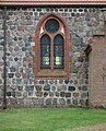 Dorfkirche Gottberg 2021 Nordfenster.jpg 3,648 × 4,527; 4 MB
-
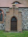 Dorfkirche Gottberg 2021 Nordportal.jpg 3,550 × 4,734; 3.23 MB
-
 Dorfkirche Gottberg 2021 S.jpg 4,608 × 3,456; 6.29 MB
-
 Dorfkirche Gottberg 2021 SE.jpg 4,032 × 3,024; 3.93 MB
-
 Dorfkirche Gottberg 2021 SW.jpg 4,864 × 3,648; 3.7 MB
-
 Dorfkirche Gottberg 2021 Südfenster.jpg 3,243 × 4,864; 3.12 MB
-
 Dorfkirche Gottberg 2021 Südwand.jpg 4,864 × 3,648; 6.34 MB
-
 Dorfkirche Gottberg 2021 Südwestfenster.jpg 3,514 × 4,686; 4.32 MB
-
 Dorfkirche Gottberg 2021 Turmhaube.jpg 4,864 × 3,648; 4.22 MB
-
 Dorfkirche Gottberg 2021 Westportal.jpg 3,648 × 4,778; 4.53 MB
-
 Gottberg (Märkisch Linden) Kirche.jpg 3,731 × 3,233; 9.49 MB
-
 Gottberg Dorfkirche.JPG 6,000 × 4,000; 6.67 MB
-
 Gottberg Kirche.jpg 4,320 × 3,240; 2.99 MB
-
 Pfarrhaus Gottberg 2016 N.jpg 4,864 × 3,648; 5.35 MB


_Kirche.jpg)


