Category:Dorfkirche Blankenfelde
Jump to navigation
Jump to search
| Object location | | View all coordinates using: OpenStreetMap |
|---|
church building in Blankenfelde-Mahlow, Germany | |||||
| Upload media | |||||
| Instance of | |||||
|---|---|---|---|---|---|
| Location | Blankenfelde, Blankenfelde-Mahlow, Teltow-Fläming District, Brandenburg, Germany | ||||
| Heritage designation | |||||
 | |||||
This is the category of the Brandenburger Baudenkmal (cultural heritage monument) with the ID 09105265 (Wikidata)
|
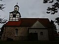
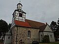
Deutsch: Die Dorfkirche in Blankenfelde, Mark Brandenburg, gehört und dient einer Gemeinde der unierten Evangelischen Kirche Berlin-Brandenburg-Schlesische Oberlausitz. Die Kirche entstand in der zweiten Hälfte des 13. Jh.s und wurde im 16. Jh. erweitert. Der Dachturm wurde 1710 erbaut. 1978 brannte die Kirche ab und wurde bis 1981 wiederaufgebaut.
English: The Village Church in Blankenfelde, Brandenburg state, Germany, is owned and used by a congregation within the Evangelical Church of Berlin-Brandenburg-Silesian Upper Lusatia, a united Protestant church body of Calvinist, Lutheran and united congregations. The church was erected in the 2nd half of the 13th c. and extended in the 16th c. The tower was added in 1710. In 1978 the church burnt out and was reconstructed until 1981.
Media in category "Dorfkirche Blankenfelde"
The following 21 files are in this category, out of 21 total.
-
 Blankenfelde church.jpg 1,380 × 1,650; 345 KB
-
 Blankenfelde, Dorfkirche (1).jpg 1,024 × 768; 116 KB
-
 Blankenfelde, Dorfkirche (2).jpg 1,566 × 1,154; 335 KB
-
 Blankenfelde, Dorfkirche (3).jpg 887 × 1,187; 175 KB
-
 Blankenfelde, Dorfkirche (4).jpg 480 × 640; 54 KB
-
 Blankenfelde, Dorfkirche (5).jpg 1,500 × 1,200; 379 KB
-
 Dorfkirche Blankenfelde Dorfstrasse.jpg 3,872 × 2,592; 3.9 MB
-
 Dorfkirche Blankenfelde Glocke vom Brand 1975.jpg 4,608 × 3,456; 6.65 MB
-
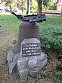
 Dorfkirche Blankenfelde Grab Otto Wildelau.jpg 4,608 × 3,456; 6.29 MB
-
 Dorfkirche Blankenfelde Nordansicht.jpg 4,608 × 3,456; 5.21 MB
-
 Dorfkirche Blankenfelde Nordostansicht.jpg 4,608 × 3,456; 4.73 MB
-
 Dorfkirche Blankenfelde Ostansicht.jpg 3,456 × 4,608; 5.07 MB
-
 Dorfkirche Blankenfelde Südansicht.jpg 4,608 × 3,456; 3.62 MB
-
 Dorfkirche Blankenfelde Südostansicht.jpg 4,608 × 3,456; 5.87 MB
-
 Dorfkirche Blankenfelde Südwestansicht.jpg 4,608 × 3,456; 4.58 MB
-
 Dorfkirche Blankenfelde TF 006.jpg 800 × 533; 308 KB
-
 Dorfkirche Blankenfelde Westansicht.jpg 3,456 × 4,608; 4.01 MB
-
 Dorfkirche Blankenfelde Westportal.jpg 4,608 × 3,456; 5.21 MB
-
 Dorfkirche Blankenfelde Westturm Südansicht.jpg 3,456 × 4,608; 3.22 MB
-
 Dorfkirche Blankenfelde-Mahlow - Deutschland - panoramio.jpg 1,944 × 2,592; 1.71 MB
-
 Kirche Blankenfelde - Erinnerungsglocke - panoramio.jpg 1,944 × 2,592; 2.7 MB
.jpg)
.jpg)
.jpg)
.jpg)
.jpg)
Categories:
- Churches in Blankenfelde-Mahlow
- Cultural heritage monuments in Blankenfelde-Mahlow
- Blankenfelde (Blankenfelde-Mahlow)
- Churches in Kirchenkreis Zossen-Fläming
- Lutheran churches in Brandenburg
- Fieldstone churches in Brandenburg
- Gothic churches in Brandenburg
- 13th-century churches in Brandenburg
- Destroyed in 1978
- Churches in Brandenburg built in 1981