Category:Dorfkirche (Frankenfelde im Fläming)
Jump to navigation
Jump to search
| Object location | | View all coordinates using: OpenStreetMap |
|---|
 | |||||
| Upload media | |||||
| Instance of | |||||
|---|---|---|---|---|---|
| Location | Frankenfelde, Luckenwalde, Teltow-Fläming District, Brandenburg, Germany | ||||
 | |||||
This is the category of the Brandenburger Baudenkmal (cultural heritage monument) with the ID 09105429 (Wikidata)
|
Deutsch: Die Dorfkirche von Frankenfelde (Fläming).
Media in category "Dorfkirche (Frankenfelde im Fläming)"
The following 17 files are in this category, out of 17 total.
-
 Dorfkirche Frankenfelde - Germany - panoramio.jpg 2,592 × 1,944; 1.61 MB
-
 Dorfkirche Frankenfelde - panoramio.jpg 2,592 × 1,944; 2.57 MB
-
 Dorfkirche Frankenfelde Blick ins Kirchenschiff.jpg 4,032 × 3,024; 1.47 MB
-
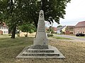 Dorfkirche Frankenfelde Denkmal Weltkriege linke Seite.jpg 4,032 × 3,024; 4.63 MB
-
 Dorfkirche Frankenfelde Denkmal Weltkriege rechte Seite.jpg 4,032 × 3,024; 5.08 MB
-
 Dorfkirche Frankenfelde Denkmal Weltkriege Rückseite.jpg 4,032 × 3,024; 3.53 MB
-
 Dorfkirche Frankenfelde Denkmal Weltkriege Vorderseite.jpg 4,032 × 3,024; 4.8 MB
-
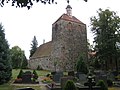
 Dorfkirche Frankenfelde Nordansicht.jpg 4,032 × 3,024; 2.84 MB
-
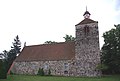
 Dorfkirche Frankenfelde Nordostansicht.jpg 3,024 × 4,032; 3.26 MB
-
 Dorfkirche Frankenfelde Ostansicht mit Grabsteinen.jpg 3,024 × 4,032; 4.36 MB
-
 Dorfkirche Frankenfelde Ostansicht.jpg 3,024 × 4,032; 3.81 MB
-
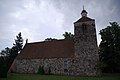
 Dorfkirche Frankenfelde Südansicht.jpg 4,032 × 3,024; 4.21 MB
-
 Dorfkirche Frankenfelde Westportal.jpg 4,032 × 3,024; 5.82 MB
-
 Dorfkirche Frankenfelde Westturm Südansicht.jpg 3,024 × 4,032; 3.96 MB
-
 Dorfkirche Frankenfelde Westturm Westansicht.jpg 3,024 × 4,032; 4.74 MB
-
 Frankenfelde Luckenwalde Kirche v N.jpg 3,871 × 2,601; 4.69 MB
-
 Kirche Frankenfelde Luckenwalde.jpg 3,872 × 2,592; 1.01 MB


