Category:Doopsgezinde kerk, Hoorn
Jump to navigation
Jump to search
Nederlands: Deze categorie bevat zowel de rijksmonumentale pastorie als de kerk dat een gemeentelijk monument is.
English: This category both has the parish house, rijksmonument, and the church. The church is a municipal monument (gemeentelijk monument).
|
This is a category about rijksmonument number 22545
|
| Address |
|
|
This is a category about a municipal monument in Hoorn with number WN409 |
| Address |
|
| Object location | | View all coordinates using: OpenStreetMap |
|---|
 | |||||
| Upload media | |||||
| Instance of | |||||
|---|---|---|---|---|---|
| Location | Hoorn, North Holland, Netherlands | ||||
| Street address |
| ||||
| Located on street | |||||
| Heritage designation |
| ||||
 | |||||
Media in category "Doopsgezinde kerk, Hoorn"
The following 12 files are in this category, out of 12 total.
-
 Action Hoorn Ramen 31.jpg 480 × 640; 94 KB
-
 Binnenstad Hoorn, 1621 Hoorn, Netherlands - panoramio (130).jpg 4,896 × 3,264; 1.83 MB
-
 Binnenstad Hoorn, 1621 Hoorn, Netherlands - panoramio (66).jpg 2,048 × 1,375; 602 KB
-
 Doopsgezinde Pastorie Ramen 29 te Hoorn.jpg 640 × 480; 81 KB
-
 Interieur - Hoorn - 20115989 - RCE.jpg 957 × 1,200; 189 KB
-
 Interieur - Hoorn - 20115990 - RCE.jpg 1,200 × 958; 222 KB
-
 Orgel Doopsgezinde Kerk.jpg 120 × 119; 4 KB
-
 Ornamenten interieur Ramen 31, Hoorn.JPG 2,592 × 3,888; 2.13 MB
-
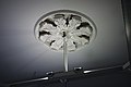 Plafondornament Ramen 31, Hoorn.JPG 3,888 × 2,592; 2.43 MB
-
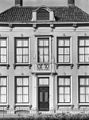
 Voorgevel - Hoorn - 20116628 - RCE.jpg 1,182 × 1,200; 290 KB
-
 Voorgevel - Hoorn - 20116630 - RCE.jpg 890 × 1,200; 233 KB
-
 Voorgevels - Hoorn - 20116629 - RCE.jpg 1,198 × 1,200; 368 KB

.jpg)
.jpg)


