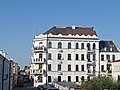
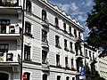
Category:Dom Centralny in Zamość
Jump to navigation
Jump to search
| Object location | | View all coordinates using: OpenStreetMap |
|---|
house in Zamość, Poland  | |||||
| Upload media | |||||
| Instance of | |||||
|---|---|---|---|---|---|
| Location | Zamość, Lublin Voivodeship, Poland | ||||
| Street address |
| ||||
| Heritage designation |
| ||||
 | |||||
Polski: Zamość, ul. S. Żeromskiego 3 / ul. Bazyliańska 19 / ul. T. Kościuszki 4 - Dom Centralny, tzw. Centralka (1910-11 r.)
Media in category "Dom Centralny in Zamość"
The following 21 files are in this category, out of 21 total.
-
 Bolesław Leśmian plaque in Zamość.jpg 2,112 × 2,816; 875 KB
-
 Centralka.jpg 3,379 × 2,527; 1.4 MB
-
 Former hotel Centralny in Zamość.jpg 2,112 × 2,816; 1.37 MB
-
 Zamosc Dom Centralny.jpg 5,184 × 3,456; 10.07 MB
-
 Zamość, Dom Centralny - fotopolska.eu (321060).jpg 1,404 × 1,053; 322 KB
-
 Zamość, Dom Centralny - fotopolska.eu (321063).jpg 1,404 × 1,053; 347 KB
-
 Zamość, Dom Centralny - fotopolska.eu (321079).jpg 1,645 × 1,370; 377 KB
-
 Zamość, Dom Centralny - fotopolska.eu (321081).jpg 1,380 × 1,192; 336 KB
-
 Zamość, Dom Centralny - fotopolska.eu (321085).jpg 554 × 1,365; 129 KB
-
 Zamość, Dom Centralny - fotopolska.eu (321086).jpg 774 × 1,375; 219 KB
-
 Zamość, Dom Centralny - fotopolska.eu (321087).jpg 730 × 1,368; 184 KB
-
 Zamość, Dom Centralny - fotopolska.eu (321088).jpg 612 × 1,362; 150 KB
-
 Zamość, Dom Centralny.jpg 1,280 × 960; 308 KB
-
 Zamość. Dom Centralny (1).jpg 900 × 1,200; 436 KB
-
 Zamość. Dom Centralny (2).jpg 900 × 1,200; 384 KB
-
 Zamość. Dom Centralny (3).jpg 1,200 × 900; 399 KB
-
 Zamość. Dom Centralny (4).jpg 1,178 × 900; 413 KB
-
 Zamość. Dom Centralny (5).jpg 1,185 × 828; 383 KB
-
 Zamość. Dom Centralny (6).jpg 932 × 733; 306 KB
-
 Zamość. Dom Centralny (7).jpg 1,200 × 900; 514 KB
-
 Zygmunt Pomarański. Tablica w Zamościu ul. Bazyliańska.jpg 2,119 × 1,469; 826 KB


.jpg)
.jpg)
.jpg)
.jpg)
.jpg)
.jpg)
.jpg)
.jpg)
.jpg)
.jpg)
.jpg)
.jpg)
.jpg)
.jpg)

.jpg)