Category:Doelenbrug (Gouda)
Jump to navigation
Jump to search
| Object location | | View all coordinates using: OpenStreetMap |
|---|
|
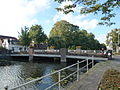
This is a category about a municipal monument in Gouda with number 643 |
Media in category "Doelenbrug (Gouda)"
The following 2 files are in this category, out of 2 total.
-
 Brug. Doelenbrug. Fluwelensingel in Gouda.JPG 4,320 × 3,240; 5.69 MB
-
 Brug. Doelenbrug. Lantaarn. Fluwelensingel in Gouda.JPG 3,240 × 4,320; 4.4 MB

