Category:Dodewaard
Jump to navigation
Jump to search
village in Neder-Betuwe, Netherlands    | |||||
| Upload media | |||||
| Spoken text audio | |||||
|---|---|---|---|---|---|
| Instance of |
| ||||
| Location |
| ||||
| Located in or next to body of water | |||||
| Population |
| ||||
 | |||||
Subcategories
This category has the following 12 subcategories, out of 12 total.
- Maps of Dodewaard (2 F)
D
G
- Geurts conserven (1 F)
H
J
M
- Memorials in Dodewaard (2 F)
R
V
- Vredo (10 F)
Media in category "Dodewaard"
The following 32 files are in this category, out of 32 total.
-
 Dodewaard wapen.svg 470 × 743; 362 KB
-
 Dodewaard vlag.svg 450 × 300; 251 bytes
-
 Achter- en zijgevel nr. L 399 - Dodewaard - 20488563 - RCE.jpg 1,200 × 900; 157 KB
-
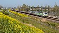
 Betuweroute - Dodewaard - 20387605 - RCE.jpg 1,200 × 794; 162 KB
-
 Betuweroute Dodewaard 20080223B.jpg 2,304 × 1,536; 809 KB
-
 Bij Dodewaard, bedrijf aan de Zandvoort IMG 2739 2019-10-26 15.31.jpg 5,472 × 3,040; 14.6 MB
-
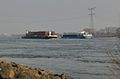 De Waal bij Dodewaard - Dodewaard - 20387729 - RCE.jpg 1,200 × 794; 132 KB
-
 De Waal bij Dodewaard - Dodewaard - 20387730 - RCE.jpg 1,200 × 794; 125 KB
-
 Dodewaard (2642472571).jpg 3,888 × 2,592; 3.85 MB
-
 Dodewaard (2642489171).jpg 3,888 × 2,592; 4.07 MB
-
 Dodewaard (Netherlands 2018) (43849212081).jpg 1,600 × 1,200; 264 KB
-
 Dodewaard DBC 193 304 Unit Cargo (51147567550).jpg 5,733 × 3,225; 13.29 MB
-
 Dodewaard LINΞΛS 186 294 ketels (51152335706).jpg 6,003 × 3,377; 15.49 MB
-
 Dodewaard, voormalig gemeentehuis.JPG 3,648 × 2,736; 4.21 MB
-
 Exterieur OVERZICHT - Dodewaard - 20313814 - RCE.jpg 1,172 × 1,200; 405 KB
-

-

-
 Map - NL - Neder-Betuwe - Wijk 02 Dodewaard - Buurt 01 Kom Wely.svg 375 × 375; 27 KB
-

-

-
 Opheusden Betuwe Route Lineas 186 453 Saxiona Xpress (48744772387).jpg 5,349 × 3,009; 14.99 MB
-
 Opheusden DB 193 363 (I am a climate hero) UC (49749825388).jpg 5,472 × 3,078; 23.16 MB
-
 Opheusden ICE3m 4603-4601 omgeleide ICE 405 via BR Basel SBB (29169778317).jpg 5,685 × 3,198; 15.87 MB
-
 Opheusden ICE3m 4611 over de BR omgeleide ICE 342 Utrecht Centraal - Flickr - Rob Dammers.jpg 5,820 × 3,274; 16.26 MB
-
 Opheusden RTB Cargo 193 792 Nurnberg Shuttle 44371 (33956360008).jpg 5,755 × 3,237; 14.31 MB
-

-
 Portret van Margaretha Vijgh.jpg 812 × 1,000; 140 KB
-
 Redgereedschap.JPG 1,440 × 2,160; 869 KB
-
 Tankautospuit.JPG 2,160 × 1,440; 1.16 MB
-

-
 Voor- en zijgevel nr. L 398 - Dodewaard - 20488564 - RCE.jpg 1,200 × 900; 153 KB
-
 Zicht op de Betuwelijn nabij Dodewaard - Dodewaard - 20409674 - RCE.jpg 1,200 × 800; 173 KB


.jpg)
.jpg)
_(43849212081).jpg)
.jpg)
.jpg)


.jpg)
_UC_(49749825388).jpg)
.jpg)

.jpg)


