Category:Disused railway lines in Derbyshire
Jump to navigation
Jump to search
Subcategories
This category has the following 14 subcategories, out of 14 total.
Media in category "Disused railway lines in Derbyshire"
The following 27 files are in this category, out of 27 total.
-
 1970 Torr Side, New Mills and Hayfield railway branch.jpg 7,198 × 4,386; 6.42 MB
-
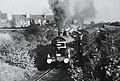 43953 ,Clowne. (3155123860).jpg 770 × 519; 89 KB
-
 Derby Midland Railway.jpg 900 × 1,103; 141 KB
-
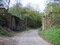
 Dismantled Railway Bridge - geograph.org.uk - 741822.jpg 640 × 479; 137 KB
-
 Dismantled railway near Hurdlow Town - geograph.org.uk - 1230519.jpg 640 × 480; 85 KB
-
 Disused coal depot railway line - geograph.org.uk - 2441018.jpg 950 × 713; 288 KB
-
 Disused Railway Embankment - geograph.org.uk - 2443625.jpg 640 × 427; 256 KB
-
 Disused railway line, Staveley - geograph.org.uk - 2441422.jpg 950 × 713; 299 KB
-
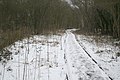
 Disused trackbed - geograph.org.uk - 3378932.jpg 4,000 × 3,000; 1.83 MB
-
 Hurdlow Incline, Sparklow - geograph.org.uk - 3471488.jpg 2,138 × 1,426; 3.14 MB
-
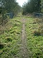
 Nature reserve footpath (4318611419).jpg 2,000 × 1,500; 1.69 MB
-
 No more trains - geograph.org.uk - 384504.jpg 480 × 640; 159 KB
-
 Old Railway Signal - geograph.org.uk - 312434.jpg 480 × 640; 119 KB
-
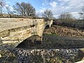
 Pointless bridge - geograph.org.uk - 515450.jpg 640 × 480; 110 KB
-

-
-
 Ripley greenway geograph-2435421-by-Trevor-Rickard.jpg 1,024 × 768; 422 KB
-
 Shirebrook North on Leen Valley linegeograph-2840749-by-Ben-Brooksbank.jpg 2,391 × 1,395; 1.01 MB
-
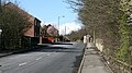 Station Road - geograph.org.uk - 371509.jpg 640 × 360; 85 KB
-
 Station Road - geograph.org.uk - 371518.jpg 640 × 360; 68 KB
-
 Summer 1961 Hayfield-Manchester timetable.jpg 2,244 × 3,622; 3.4 MB
-
-
 The Nutbrook Trail - geograph.org.uk - 775261.jpg 640 × 427; 119 KB
-
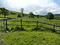
 The Unstone Line - geograph.org.uk - 1735341.jpg 1,280 × 853; 277 KB
-
 Track of dismantled railway - geograph.org.uk - 2437509.jpg 3,648 × 2,736; 6.03 MB
-
 Train at Low Leighton on Hayfield branch.jpg 1,001 × 736; 978 KB
-
 Westhouses curve.jpg 2,500 × 1,875; 2.54 MB

.jpg)


.jpg)


