Category:Distribution maps for The Church of Jesus Christ of Latter-day Saints in the United States
Jump to navigation
Jump to search
Media in category "Distribution maps for The Church of Jesus Christ of Latter-day Saints in the United States"
The following 20 files are in this category, out of 20 total.
-
 Map of USA highlighting Jello Belt.png 280 × 183; 37 KB
-
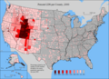 LDS Percentage of Population 2000.PNG 886 × 643; 102 KB
-
 Plurality religious denomination by U.S. state, 2001.svg 959 × 593; 72 KB
-
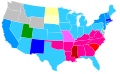
 Religions of the US.PNG 1,513 × 1,031; 79 KB
-
 US LDS percent 2001.svg 959 × 593; 171 KB
-
 2006 United States LDS membership.PNG 577 × 389; 23 KB
-
 US LDS percent 2006.svg 959 × 593; 171 KB
-
 2007 LDS Membership.PNG 562 × 344; 18 KB
-
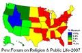 2007 PEW Survey (Percent Mormon).PNG 569 × 372; 23 KB
-
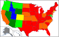
 Latter-day Saint Membership per capita.PNG 549 × 327; 17 KB
-
 US LDS Membership per capita 2009.PNG 549 × 327; 16 KB
-
 2012 LDS Membership.png 562 × 344; 21 KB
-
 Counties of Utah by percentage of Latter-day Saint adherence.svg 512 × 640; 25 KB
-

-
 Mormon belt map with no outlines.svg 512 × 324; 1.89 MB
-
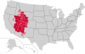 Mormon belt map with outlines.svg 512 × 324; 1.83 MB
-
 Mormon belt map.svg 512 × 324; 1.64 MB
-
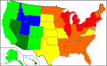
 MormonPercentageByUSState.svg 512 × 317; 33 KB
-

-
 US LDS Membership per capita 2011.png 549 × 327; 20 KB


.PNG)


