Category:Dickens Avenue, Mayer Park
Jump to navigation
Jump to search
| Object location | | View all coordinates using: OpenStreetMap |
|---|
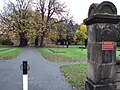
Avenue of horse chestnut treees, renamed on 10th April 1869 by Joseph Mayer after attending an honorary dinner for Charles Dickens in St George's Hall, Liverpool.
Media in category "Dickens Avenue, Mayer Park"
The following 6 files are in this category, out of 6 total.
-
 Bebington - DSC04505.JPG 3,648 × 2,736; 3.55 MB
-
 Dickens Avenue stone 1, Mayer Park.jpg 4,184 × 3,252; 12.77 MB
-
 Dickens Avenue stone 2, Mayer Park.jpg 5,226 × 3,484; 16.55 MB
-
 Dickens Avenue, Mayer Park 1.jpg 5,319 × 3,546; 21.42 MB
-
 Dickens Avenue, Mayer Park 2.jpg 5,041 × 3,347; 13.95 MB
-
 Entrance to Mayer Park, The Village.jpg 4,300 × 2,828; 6.31 MB


