Category:Diagrams of submarine landforms
Jump to navigation
Jump to search
Media in category "Diagrams of submarine landforms"
The following 11 files are in this category, out of 11 total.
-
 Blake Plateau profile comparison.jpg 726 × 741; 311 KB
-
 Continental shelf.png 456 × 180; 7 KB
-
 Ocean Bottom Bul.png 8,000 × 2,250; 159 KB
-
 Oceanic divisions es.svg 1,114 × 835; 23 KB
-
 Oceanic divisions ru.svg 1,114 × 835; 43 KB
-
 Oceanic divisions uk.svg 1,114 × 835; 43 KB
-
 Oceanic.Stripe.Magnetic.Anomalies.Scheme.fr.gif 260 × 190; 17 KB
-
 Plataforma Continental.png 2,738 × 1,080; 53 KB
-
 South profile.jpg 1,024 × 223; 142 KB
-
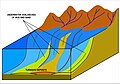
 Submarine canyon.png 1,384 × 787; 758 KB
-
 Turbidite formation.jpg 3,003 × 2,093; 783 KB


