Category:Devil's Chimney, Gloucestershire
Jump to navigation
Jump to search
Devil's Chimney, Gloucestershire
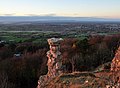
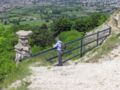
A largely man-made pillar outcrop on Leckhampton Hill, South of Cheltenham, formed when an incline to a quarry was cut behind it, isolating the pillar from the main hillside.
| Object location | | View all coordinates using: OpenStreetMap |
|---|
rock formation | |||||
| Upload media | |||||
| Location |
| ||||
|---|---|---|---|---|---|
 | |||||
Media in category "Devil's Chimney, Gloucestershire"
The following 17 files are in this category, out of 17 total.
-
 -Group of 11 Early Stereograph Views of British Landscapes- MET DP73089.jpg 4,000 × 1,954; 2.95 MB
-
 Devil's Chimney - geograph.org.uk - 2217475.jpg 600 × 450; 37 KB
-
 Devil's Chimney and Cheltenham.jpg 3,656 × 2,696; 3.89 MB
-
 Devil's Chimney on Leckhampton Hill - geograph.org.uk - 1990413.jpg 3,008 × 2,000; 1.56 MB
-
 Devil's Chimney, Leckhampton Hill - geograph.org.uk - 654214.jpg 426 × 640; 90 KB
-
 Devil's Chimney.jpg 2,848 × 3,808; 5.7 MB
-
 Devils Chimney 062515.JPG 3,872 × 2,592; 7 MB
-
 Devils.chimney.at.leckhampton.arp.jpg 2,288 × 1,712; 800 KB
-
 Devils.chimney.viewpoint.at.leckhampton.arp.jpg 2,288 × 1,712; 2.69 MB
-
 Leckhampton Hill Nature Reserve - geograph.org.uk - 2692504.jpg 4,288 × 3,216; 1.54 MB
-
 The Devil's Chimney - geograph.org.uk - 1191527.jpg 640 × 499; 105 KB
-
 The Devil's Chimney - geograph.org.uk - 1990426.jpg 2,000 × 3,008; 1.5 MB
-
 The Devil's Chimney - geograph.org.uk - 2692620.jpg 4,288 × 3,216; 5.18 MB
-
 The Devil's Chimney - geograph.org.uk - 3948.jpg 480 × 640; 94 KB
-
 The Devil's Chimney - geograph.org.uk - 638752.jpg 640 × 431; 84 KB
-
 The Devil's Chimney on Leckhampton Hill above Cheltenham Spa - geograph.org.uk - 1990434.jpg 2,000 × 3,008; 1.39 MB
-
 The Devil's Chimney- a quarryman's prank^ - geograph.org.uk - 1990390.jpg 3,008 × 2,000; 1.54 MB


