Category:Denning, New York
Jump to navigation
Jump to search
human settlement in New York, United States of America   | |||||
| Upload media | |||||
| Instance of | |||||
|---|---|---|---|---|---|
| Location | Ulster County, New York | ||||
| Inception |
| ||||
| Population |
| ||||
| Area |
| ||||
| Elevation above sea level |
| ||||
 | |||||
Images taken in or otherwise pertinent to the Town of Denning, in Ulster County, NY, USA
Subcategories
This category has only the following subcategory.
R
Media in category "Denning, New York"
The following 17 files are in this category, out of 17 total.
-
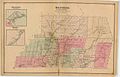 Beers Ulster County Atlas Page046-047.jpg 1,566 × 1,000; 280 KB
-
 Biscuit Brook at Pine Hill-West Branch Trail crossing, Frost Valley, NY.jpg 3,192 × 2,094; 4.33 MB
-
 Biscuit Brook Lean-To, Frost Valley, NY.jpg 2,802 × 1,836; 3 MB
-
 Catskill forest on summer afternoon off Pine Hill-West Branch Trail, Frost Valley, NY 2.jpg 2,320 × 3,264; 4.32 MB
-
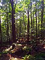 Catskill forest on summer afternoon off Pine Hill-West Branch Trail, Frost Valley, NY.jpg 2,448 × 3,264; 3.97 MB
-
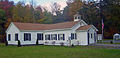 Denning, NY, town hall.jpg 2,380 × 1,152; 607 KB
-
 Downed trees on Peekamoose-Table Trail after Hurricane Irene.jpg 3,428 × 2,660; 2.79 MB
-
 Late afternoon sunlight in Catskill forest near Frost Valley, NY.jpg 2,184 × 2,904; 3.06 MB
-
 Pavement washed off Peekamoose Road after Hurricane Irene, Sundown, NY.jpg 3,932 × 2,400; 3.6 MB
-
 Peekamoose and Table Mountains, NY.jpg 1,722 × 1,162; 1.71 MB
-
 Peekamoose Mountain Great Southern Overlook panorama.jpg 10,679 × 2,829; 16.13 MB
-
 Peekamoose Mountain summit rock.jpg 3,381 × 2,193; 6.4 MB
-
 Peekamoose Valley Wild Forest after Hurricane Irene floods, Sundown, NY.jpg 3,584 × 2,796; 4.08 MB
-
 Rondout Creek after Hurricane Irene.jpg 3,006 × 3,414; 2.78 MB
-
 Table Mountain from Curtis-Ormsbee Trail.jpg 4,440 × 3,144; 11.09 MB
-

-
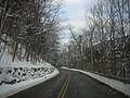 Ulster County Route 47.jpg 1,024 × 768; 191 KB


