Category:Cumulative Atlantic hurricane trackmaps
Jump to navigation
Jump to search
Media in category "Cumulative Atlantic hurricane trackmaps"
The following 26 files are in this category, out of 26 total.
-
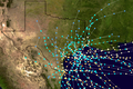
 2011 AHS prelim track.png 3,300 × 2,550; 1.21 MB
-
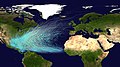 Atlantic hurricane tracks.jpg 9,000 × 5,044; 35.69 MB
-
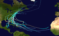
 Atlantic hurricane tracks 1980-2005.jpg 4,000 × 2,472; 2.25 MB
-
 Atlantic November hurricanes BM2002.png 4,000 × 2,472; 6.42 MB
-
 Atlantic November hurricanes BMNG.png 4,000 × 2,472; 6.25 MB
-
 Bermuda hurricane landfalls map.png 4,000 × 3,478; 6.38 MB
-
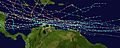
 Cape Verde hurricane track - ru.png 1,290 × 511; 221 KB
-
 Cape Verde hurricane track.jpg 2,550 × 944; 317 KB
-
 Delaware hurricane tracks.jpg 1,600 × 1,200; 246 KB
-
 Florida hurricane (1900-1949) tracks.png 1,200 × 800; 1.06 MB
-
 Florida hurricane (1950-1974) tracks.jpg 1,200 × 800; 246 KB
-
 Florida hurricane (1975-1999) tracks.jpg 1,200 × 800; 232 KB
-
 Florida hurricane (pre-1900) tracks.jpg 1,200 × 800; 316 KB
-
 Landfalling New York hurricanes.png 1,024 × 659; 442 KB
-
 N Atl Hurricane climatology.png 904 × 831; 132 KB
-
 New Jersey Tropical Cyclone strikes from 1851 - 2022..png 1,524 × 922; 1.22 MB
-
 Retired Atlantic hurricane tracks.png 4,000 × 2,472; 8.77 MB
-
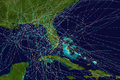
 South American hurricane tracks.jpg 2,500 × 1,000; 363 KB
-
 Texas hurricane (pre-1900) tracks.png 1,200 × 800; 1.55 MB
-
 Texas hurricane tracks.png 5,000 × 5,000; 23.99 MB
-
 Typical North Atlantic Tropical Cyclone Formation in August.png 450 × 227; 20 KB
-
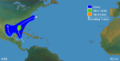
 Typical North Atlantic Tropical Cyclone Formation in July.png 450 × 227; 20 KB
-
 Typical North Atlantic Tropical Cyclone Formation in June.png 450 × 227; 20 KB
-
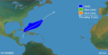 Typical North Atlantic Tropical Cyclone Formation in November.png 450 × 227; 20 KB
-
 Typical North Atlantic Tropical Cyclone Formation in October.png 450 × 227; 20 KB
-
 Typical North Atlantic Tropical Cyclone Formation in September.png 450 × 227; 20 KB


_tracks.png)
_tracks.jpg)
_tracks.jpg)
_tracks.jpg)


_tracks.png)


