Category:Cropton Forest
Jump to navigation
Jump to search
English: Cropton Forest extends over the civil parishes of Hartoft, Stape, and Cropton (in the district of Ryedale
Subcategories
This category has the following 2 subcategories, out of 2 total.
M
- Mauley Cross (9 F)
N
- Newton Dale Halt railway station (13 F)
Media in category "Cropton Forest"
The following 90 files are in this category, out of 90 total.
-
 Afternoon Rainbow - geograph.org.uk - 9608.jpg 640 × 480; 78 KB
-
 Blawath Road - geograph.org.uk - 3210689.jpg 768 × 1,024; 248 KB
-
 Blocked Track in Cropton Forest - geograph.org.uk - 712373.jpg 640 × 427; 319 KB
-
 Brown Head (2) - geograph.org.uk - 712444.jpg 640 × 427; 254 KB
-
 Clearfell in Cropton Forest - geograph.org.uk - 712435.jpg 640 × 427; 256 KB
-
 Cropton Forest at Muffles Rigg - geograph.org.uk - 2739591.jpg 2,048 × 1,360; 657 KB
-
 Cropton Forest Drive - geograph.org.uk - 185931.jpg 480 × 640; 69 KB
-
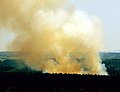 Cropton Forest Fire - geograph.org.uk - 1895724.jpg 2,796 × 2,141; 1.34 MB
-
 Cropton Forest Lodges - geograph.org.uk - 2664357.jpg 1,296 × 968; 607 KB
-
 Cropton Forest. - geograph.org.uk - 579251.jpg 640 × 367; 262 KB
-
 Elleron Lake - geograph.org.uk - 1607878.jpg 640 × 466; 95 KB
-
 Environment Agency Raingauge - geograph.org.uk - 277725.jpg 640 × 427; 69 KB
-
 Extreme Fire Risk - geograph.org.uk - 185918.jpg 640 × 480; 99 KB
-
 Fallen Oak Leaves - geograph.org.uk - 586227.jpg 640 × 427; 141 KB
-
 Fallen Pine Cones in Cropton Forest - geograph.org.uk - 712468.jpg 427 × 640; 313 KB
-
 Fallen Tree - Cropton Forest - geograph.org.uk - 2739583.jpg 2,048 × 1,360; 666 KB
-
 Field, Cropton Forest - geograph.org.uk - 152916.jpg 640 × 480; 108 KB
-
 Forest ride in Cropton Forest - geograph.org.uk - 3734443.jpg 1,500 × 955; 1.68 MB
-
 Forest Track, Cropton Forest - geograph.org.uk - 1924005.jpg 427 × 640; 298 KB
-
 Forestry Track on Esp Rigg. - geograph.org.uk - 579209.jpg 640 × 427; 283 KB
-
 Fungi on Tree in Cropton Forest. - geograph.org.uk - 300271.jpg 480 × 640; 280 KB
-
 Life House - geograph.org.uk - 916863.jpg 640 × 479; 111 KB
-
 Light Snow in Cropton Forest - geograph.org.uk - 764702.jpg 427 × 640; 67 KB
-
 Low Muffles Hartoft - geograph.org.uk - 1498682.jpg 640 × 427; 102 KB
-
 Near Raindale Head in Cropton Forest - geograph.org.uk - 521982.jpg 640 × 480; 105 KB
-
 Owl Box in Cropton Forest - geograph.org.uk - 1753798.jpg 1,360 × 2,048; 662 KB
-

-

-
 Sitka Spruce in Cropton Forest - geograph.org.uk - 1498676.jpg 640 × 427; 98 KB
-
 Small Embankment in Cropton Forest - geograph.org.uk - 761590.jpg 427 × 640; 98 KB
-
 Snow on the Forest Floor - geograph.org.uk - 761650.jpg 427 × 640; 84 KB
-
 Stone Gateposts in Cropton Forest - geograph.org.uk - 712369.jpg 640 × 427; 271 KB
-
 Sunset in Cropton Forest. - geograph.org.uk - 185117.jpg 640 × 480; 90 KB
-
 The forest drive near Raper's Farm - geograph.org.uk - 586213.jpg 640 × 411; 59 KB
-
 The Sickener. - geograph.org.uk - 579222.jpg 465 × 640; 268 KB
-
 The view southwards from Wheeldale Moor - geograph.org.uk - 1365926.jpg 640 × 480; 121 KB
-
 Timber Stack in Cropton Forest - geograph.org.uk - 712428.jpg 640 × 427; 265 KB
-

-
 Track in Cropton Forest - geograph.org.uk - 814060.jpg 640 × 427; 254 KB
-

-
 Tree Felling Machine in Cropton Forest - geograph.org.uk - 712432.jpg 640 × 427; 300 KB
-
 Tree Ranks in Cropton Forest (2) - geograph.org.uk - 712474.jpg 427 × 640; 286 KB
-
 Tree Ranks in Cropton Forest - geograph.org.uk - 712362.jpg 427 × 640; 284 KB
-
 Trees in Cropton Forest. - geograph.org.uk - 579203.jpg 427 × 640; 334 KB
-

-
 Blackpark Lodge - geograph.org.uk - 1498685.jpg 640 × 427; 87 KB
-
 Boundary Stone in Cropton Forest. - geograph.org.uk - 194310.jpg 640 × 480; 128 KB
-
 Bridleway junction in Wardle Rigg - geograph.org.uk - 538090.jpg 640 × 480; 109 KB
-
 Clearing in Cropton Forest. - geograph.org.uk - 300283.jpg 640 × 480; 229 KB
-
 Cropton Forest - geograph.org.uk - 173217.jpg 480 × 640; 209 KB
-
 Cropton Forest - geograph.org.uk - 451079.jpg 640 × 428; 129 KB
-
 Cropton Forest - geograph.org.uk - 9581.jpg 480 × 640; 160 KB
-
 Cropton Forest at Middleton Moor. - geograph.org.uk - 194313.jpg 640 × 480; 85 KB
-
 Cropton Forest at Ramsden Head. - geograph.org.uk - 194309.jpg 640 × 480; 99 KB
-
 Cropton Forest at SE796943 - geograph.org.uk - 185936.jpg 640 × 480; 175 KB
-
 Cropton Forest at SE803946 - geograph.org.uk - 185937.jpg 480 × 640; 104 KB
-

-
 Cropton Forest Road - geograph.org.uk - 185916.jpg 640 × 480; 81 KB
-
 Cropton Forest Track - geograph.org.uk - 185917.jpg 640 × 480; 109 KB
-
 Cropton Forest Track - geograph.org.uk - 185929.jpg 640 × 480; 135 KB
-
 Cropton Forest. - geograph.org.uk - 185107.jpg 640 × 480; 99 KB
-
 Crossroads on Middleton Moor. - geograph.org.uk - 194312.jpg 640 × 480; 82 KB
-
 Deer in Cropton Forest. - geograph.org.uk - 185110.jpg 640 × 480; 94 KB
-
 Deer in Cropton Forest. - geograph.org.uk - 194316.jpg 640 × 480; 110 KB
-
 Esp Rigg - geograph.org.uk - 185928.jpg 640 × 480; 119 KB
-

-
 Firebreak in Cropton Forest. - geograph.org.uk - 194790.jpg 640 × 480; 115 KB
-
 Firebreak on Middleton Moor. - geograph.org.uk - 300238.jpg 480 × 640; 106 KB
-
 Forest Drive - geograph.org.uk - 185933.jpg 640 × 480; 108 KB
-
 Forest near Keldy Castle - geograph.org.uk - 269026.jpg 640 × 427; 71 KB
-
 Forest Road Junction, Cropton Forest - geograph.org.uk - 152932.jpg 640 × 480; 53 KB
-
 Forest Track. - geograph.org.uk - 300242.jpg 640 × 480; 271 KB
-
 Forestry Path. - geograph.org.uk - 300278.jpg 640 × 480; 276 KB
-

-
 Fork in Forestry Track. - geograph.org.uk - 185102.jpg 640 × 480; 84 KB
-
 Hartoft Moor - geograph.org.uk - 76771.jpg 640 × 480; 108 KB
-

-
 Path on Wheeldale Moor. - geograph.org.uk - 194319.jpg 640 × 480; 87 KB
-
 River Seven and Cropton Forest - geograph.org.uk - 149365.jpg 640 × 427; 52 KB
-
 Shooting House in Cropton Forest. - geograph.org.uk - 194311.jpg 640 × 480; 123 KB
-
 Skelton's View - geograph.org.uk - 191953.jpg 492 × 640; 166 KB
-
 Standing Stone in Cropton Forest. - geograph.org.uk - 300276.jpg 480 × 640; 263 KB
-
 Sunshine on Forestry. - geograph.org.uk - 300236.jpg 480 × 640; 106 KB
-
 Sutherland Lodge - geograph.org.uk - 207273.jpg 640 × 479; 79 KB
-

-
 Top of Esp Rigg. - geograph.org.uk - 185113.jpg 640 × 480; 70 KB
-
 Track in Cropton Forest - geograph.org.uk - 216373.jpg 640 × 480; 134 KB
-
 Track in Cropton Forest - geograph.org.uk - 216378.jpg 640 × 480; 132 KB
-
 Unnamed tarn - geograph.org.uk - 86517.jpg 640 × 480; 56 KB
-
 View across Newtondale - geograph.org.uk - 451098.jpg 640 × 428; 129 KB


_-_geograph.org.uk_-_712444.jpg)


_-_geograph.org.uk_-_712474.jpg)


