Category:Cottages in Cumbria
Jump to navigation
Jump to search
Ceremonial counties of England: Bedfordshire · Berkshire · Buckinghamshire · Cambridgeshire · Cheshire · Cornwall · Cumbria · Derbyshire · Devon · Dorset · Durham · East Riding of Yorkshire · East Sussex · Essex · Gloucestershire · Greater London · Greater Manchester · Hampshire · Herefordshire · Hertfordshire · Kent · Lancashire · Leicestershire · Lincolnshire · Merseyside · Norfolk · North Yorkshire · Northamptonshire · Northumberland · Nottinghamshire · Oxfordshire · Rutland · Shropshire · Somerset · South Yorkshire · Staffordshire · Suffolk · Surrey · Tyne and Wear · Warwickshire · West Midlands · West Sussex · West Yorkshire · Wiltshire · Worcestershire
City-counties: Bristol ·
Former historic counties: Huntingdonshire ·
Other former counties:
City-counties: Bristol ·
Former historic counties: Huntingdonshire ·
Other former counties:
Subcategories
This category has the following 6 subcategories, out of 6 total.
- Thatched cottages in Cumbria (2 F)
A
- Anne Tyson's cottage (5 F)
D
- Dove Cottage, Grasmere (35 F)
H
N
- Nab Cottage, Rydal (4 F)
T
- Tarn Hows Cottage, Cumbria (6 F)
Media in category "Cottages in Cumbria"
The following 200 files are in this category, out of 232 total.
(previous page) (next page)-

-
 20–26, Chapel Street, Appleby-in-Westmorland 01.jpg 4,000 × 3,000; 1.74 MB
-
 20–26, Chapel Street, Appleby-in-Westmorland 02.jpg 4,000 × 3,000; 5.16 MB
-
 20–26, Chapel Street, Appleby-in-Westmorland 03.jpg 4,000 × 3,000; 5.03 MB
-
 41, 43 and 45, Boroughgate, Appleby-in-Westmorland.jpg 4,000 × 3,000; 2.87 MB
-
 A corner at Oxen Park - geograph.org.uk - 127118.jpg 640 × 426; 112 KB
-
 A cottage at Bank End, Duddon valley - geograph.org.uk - 687141.jpg 640 × 480; 103 KB
-
 A courtyard, Cockermouth - geograph.org.uk - 5773.jpg 640 × 425; 79 KB
-
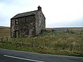
 Abandoned moorland cottage - geograph.org.uk - 53668.jpg 640 × 480; 107 KB
-
 Acorn Bank Cottages - geograph.org.uk - 2697223.jpg 3,687 × 2,297; 1.5 MB
-
 Acorn Cottage in High Lorton - geograph.org.uk - 31360.jpg 640 × 480; 97 KB
-
 Ashes Cottages - geograph.org.uk - 1956906.jpg 3,264 × 2,448; 1.34 MB
-
 B5289 south through Rosthwaite Borrowdale Cumbria.jpg 1,095 × 704; 648 KB
-
 B5289 through Rosthwaite Borrowdale Cumbria.jpg 1,257 × 753; 559 KB
-
 Beck Head cottages - geograph.org.uk - 958174.jpg 640 × 438; 121 KB
-
 Bend or Bump, Coniston.jpg 4,000 × 3,000; 1.65 MB
-
 Brackenthwaite - geograph.org.uk - 80979.jpg 640 × 480; 111 KB
-
 Braystones beach, Cumbria - geograph.org.uk - 90406.jpg 640 × 399; 95 KB
-
 Bridge End Cottages at Ennerdale Bridge - geograph.org.uk - 615511.jpg 640 × 480; 102 KB
-
 Brigham, Church Street - geograph.org.uk - 733328.jpg 640 × 480; 135 KB
-
 Brogden Cottages - panoramio.jpg 2,888 × 1,728; 2.19 MB
-
 Burnmoor Lodge - geograph.org.uk - 1174385.jpg 640 × 480; 86 KB
-
 Burthwaite Cottage - geograph.org.uk - 93356.jpg 640 × 427; 132 KB
-
 Corner Cottage, Catlowdy - geograph.org.uk - 323445.jpg 640 × 480; 231 KB
-
 Cotehill - geograph.org.uk - 195897.jpg 640 × 478; 115 KB
-
 Cottage - geograph.org.uk - 1490314.jpg 640 × 480; 62 KB
-
 Cottage and Glendale Caravan Park - geograph.org.uk - 933207.jpg 640 × 480; 75 KB
-
 Cottage and sheep-pens, Gilderdale - geograph.org.uk - 119528.jpg 640 × 480; 79 KB
-
 Cottage at Birk Field - geograph.org.uk - 3228603.jpg 640 × 480; 107 KB
-
 Cottage at Bull Close - geograph.org.uk - 1595019.jpg 640 × 426; 92 KB
-
 Cottage at Cowgill - geograph.org.uk - 1370302.jpg 640 × 480; 101 KB
-
 Cottage at Sandwick - geograph.org.uk - 891613.jpg 640 × 425; 102 KB
-
 Cottage below Hartside - geograph.org.uk - 1075036.jpg 640 × 480; 114 KB
-
 Cottage below Hartside Height - geograph.org.uk - 1297475.jpg 640 × 427; 66 KB
-
 Cottage Beneath Priest Crag - geograph.org.uk - 101016.jpg 640 × 427; 136 KB
-
 Cottage in Hartsop village - geograph.org.uk - 983543.jpg 640 × 450; 100 KB
-
 Cottage in Hartsop village - geograph.org.uk - 983559.jpg 640 × 425; 102 KB
-
 Cottage in the vernacular - geograph.org.uk - 1143028.jpg 640 × 480; 101 KB
-
 Cottage in the vernacular - geograph.org.uk - 1143064.jpg 640 × 480; 83 KB
-
 Cottage near Broadgate - geograph.org.uk - 572443.jpg 640 × 480; 101 KB
-
 Cottage near Kitchenhill, Penrith - geograph.org.uk - 996457.jpg 640 × 480; 124 KB
-
 Cottage near Rooking - geograph.org.uk - 1741614.jpg 640 × 448; 84 KB
-
 Cottage near Rydal Mount - geograph.org.uk - 989265.jpg 640 × 453; 96 KB
-

-
 Cottage on the edge of Whinneyhow Woods - geograph.org.uk - 1337306.jpg 640 × 430; 104 KB
-
 Cottage on the moor - geograph.org.uk - 1560375.jpg 640 × 480; 72 KB
-
 Cottage on track in Staveley Park - geograph.org.uk - 5444749.jpg 1,024 × 768; 310 KB
-
 Cottage with spinning gallery, Hartsop - geograph.org.uk - 983550.jpg 640 × 425; 111 KB
-
 Cottage, High Saltcoats - geograph.org.uk - 1328262.jpg 640 × 430; 159 KB
-
 Cottage, Irton Road - geograph.org.uk - 1337273.jpg 640 × 430; 89 KB
-
 Cottage, Nether Row - geograph.org.uk - 97143.jpg 640 × 454; 76 KB
-
 Cottage, Saltcoats - geograph.org.uk - 1328331.jpg 640 × 430; 68 KB
-
 Cottages above Garrigill - geograph.org.uk - 1157369.jpg 640 × 480; 70 KB
-
 Cottages at Beck Bank - geograph.org.uk - 955618.jpg 640 × 425; 73 KB
-
 Cottages at Brunstock - geograph.org.uk - 273508.jpg 640 × 480; 115 KB
-
 Cottages at Far Arnside - geograph.org.uk - 1004984.jpg 640 × 443; 84 KB
-
 Cottages at Flakebridge - geograph.org.uk - 1107796.jpg 640 × 480; 96 KB
-
 Cottages at Irton Hall - geograph.org.uk - 842977.jpg 640 × 405; 128 KB
-
 Cottages at Newtown of Rockcliffe - geograph.org.uk - 248300.jpg 640 × 480; 67 KB
-
 Cottages at Outrun Nook - geograph.org.uk - 2340028.jpg 640 × 426; 279 KB
-
 Cottages at Toppin Castle Farm - geograph.org.uk - 1841133.jpg 640 × 422; 81 KB
-
 Cottages by Reston Hall - geograph.org.uk - 3513459.jpg 3,872 × 2,592; 5.09 MB
-
 Cottages by Rusland Pool - geograph.org.uk - 1098732.jpg 538 × 640; 105 KB
-
 Cottages by the A595 at Holmrook - geograph.org.uk - 843034.jpg 640 × 459; 192 KB
-
 Cottages in Boot village - geograph.org.uk - 888551.jpg 640 × 425; 66 KB
-
 Cottages in Boot village - geograph.org.uk - 888559.jpg 640 × 425; 87 KB
-
 Cottages in Dacre near Ullswater - geograph.org.uk - 1458350.jpg 640 × 406; 168 KB
-
 Cottages in Grassgarth - geograph.org.uk - 3384686.jpg 3,872 × 2,592; 4.36 MB
-
 Cottages in Lowick Green - geograph.org.uk - 2633465.jpg 640 × 432; 61 KB
-
 Cottages near Thwaite - geograph.org.uk - 797757.jpg 640 × 480; 103 KB
-
 Cottages north of Irton Rd Station - geograph.org.uk - 1332397.jpg 640 × 430; 92 KB
-

-
 Cottages on River Kent - geograph.org.uk - 1201479.jpg 640 × 426; 129 KB
-
 Cottages south of The Green Station - geograph.org.uk - 1334470.jpg 640 × 430; 72 KB
-
 Cottages, Beech Rd - geograph.org.uk - 1344484.jpg 640 × 430; 77 KB
-
 Cottages, Bowness on Windermere - geograph.org.uk - 414281.jpg 480 × 640; 139 KB
-
 Cottages, Chapel Stile - geograph.org.uk - 359929.jpg 640 × 480; 86 KB
-
 Cottages, High Hesket - geograph.org.uk - 996744.jpg 640 × 425; 65 KB
-
 Cottages, Irton Road - geograph.org.uk - 1337307.jpg 640 × 430; 92 KB
-
 Cottages, Lorton - geograph.org.uk - 1034323.jpg 640 × 480; 122 KB
-
 Cottages, Low Tilberthwaite - geograph.org.uk - 785250.jpg 640 × 480; 85 KB
-
 Cottages, Nether Row - geograph.org.uk - 780158.jpg 640 × 480; 107 KB
-
 Cottages, Temple Sowerby - geograph.org.uk - 1807117.jpg 3,296 × 2,472; 1.9 MB
-
 Derelict cottage by Black Beck - geograph.org.uk - 1983872.jpg 640 × 480; 88 KB
-
 English Cottage - geograph.org.uk - 415975.jpg 640 × 480; 137 KB
-
 Cottage at Eskdale Green, Cumbria - geograph.org.uk - 116959.jpg 640 × 426; 98 KB
-

-
 Gardeners Cottage, Appleby-in-Westmorland.jpg 4,000 × 3,000; 1.8 MB
-
 Garsdale Head.jpg 640 × 480; 133 KB
-
 Grasmere cottage.jpg 4,608 × 3,456; 7.28 MB
-
 Grasmere cottage.JPG 4,608 × 3,456; 6.15 MB
-
 Hawkshead Methodist Chapel - geograph.org.uk - 169287.jpg 640 × 469; 81 KB
-
 Haws Bank Cottage.jpg 4,000 × 3,000; 1.49 MB
-
 High Ashgill - geograph.org.uk - 1504441.jpg 640 × 480; 88 KB
-
 Holiday Cottage Lake District - geograph.org.uk - 10553.jpg 640 × 427; 147 KB
-
 Holme Cottage, near Alston - geograph.org.uk - 172441.jpg 640 × 480; 79 KB
-
 Irish Row, Coppermines Valley, Coniston - geograph.org.uk - 16019.jpg 640 × 480; 112 KB
-
 Jitty Cottage, Battlebarrow, Appleby - geograph.org.uk - 275586.jpg 640 × 480; 83 KB
-
 Killington - House To North West Of Beck Side Farm - 20220901142956.jpg 1,600 × 1,200; 644 KB
-
 Threeways, Langrigg - geograph.org.uk - 564885.jpg 604 × 452; 135 KB
-
 Little Asby - geograph.org.uk - 209917.jpg 640 × 426; 172 KB
-
 Little Ashes Cottage - geograph.org.uk - 3377758.jpg 2,048 × 1,536; 577 KB
-
 Lowthian Cottage, Temple Sowerby - geograph.org.uk - 1498829.jpg 640 × 480; 106 KB
-
 Mill cottages, Garnett Bridge - geograph.org.uk - 1152691.jpg 640 × 480; 97 KB
-
 Nether Park - geograph.org.uk - 135232.jpg 640 × 480; 85 KB
-
 Old Barn, Dentdale - geograph.org.uk - 758514.jpg 640 × 480; 123 KB
-

-
 Old cottage on the A686 - geograph.org.uk - 157974.jpg 640 × 480; 89 KB
-
 One Ash Cottage, Staveley - geograph.org.uk - 3377773.jpg 2,048 × 1,536; 649 KB
-
 Oxen Fell cottage - geograph.org.uk - 573251.jpg 640 × 480; 102 KB
-
 Pasture and cottages, Orton - geograph.org.uk - 902097.jpg 640 × 480; 146 KB
-
 Quarry cottages - geograph.org.uk - 1346376.jpg 640 × 430; 72 KB
-
 Quiet corner in Alston - geograph.org.uk - 94626.jpg 480 × 640; 95 KB
-
 Redgatehead - geograph.org.uk - 547828.jpg 640 × 480; 120 KB
-
 Rose Bank, Temple Sowerby - geograph.org.uk - 290869.jpg 640 × 469; 113 KB
-
 Roses round the door - geograph.org.uk - 207895.jpg 640 × 480; 80 KB
-
 Row of cottages at Linstock - geograph.org.uk - 207718.jpg 640 × 480; 87 KB
-
 Scout Green Rly Cottage JP 46115 climbing Shap 03.09.16.jpg 1,400 × 1,050; 1.31 MB
-
 Seathwaite.jpg 4,608 × 3,456; 4.97 MB
-
 Shepherds Cottage - geograph.org.uk - 734906.jpg 640 × 480; 43 KB
-
 Stonethwaite main street.jpg 4,608 × 3,456; 5.57 MB
-
 Swindale Beck, Brough - geograph.org.uk - 1477537.jpg 640 × 480; 119 KB
-
 Terraced cottages, Station Road, Alston - geograph.org.uk - 297865.jpg 640 × 480; 148 KB
-
 Tewfaitegreen, Cumbria, cottages. - geograph.org.uk - 646380.jpg 640 × 480; 72 KB
-
 The Dales Way - geograph.org.uk - 3201469.jpg 800 × 600; 140 KB
-
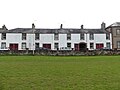
 Westmorland Cottages.png 2,010 × 1,347; 8.79 MB
-
 White Lea - geograph.org.uk - 136515.jpg 640 × 480; 73 KB
-
 White Sunlit Cottage - geograph.org.uk - 332548.jpg 640 × 426; 85 KB
-
 Yew Tree Cottage, Causewayhead - geograph.org.uk - 63488.jpg 640 × 480; 96 KB
-
 Approaching Bakerstead - geograph.org.uk - 514131.jpg 640 × 426; 107 KB
-
 Back Lane, Langwathby - geograph.org.uk - 640852.jpg 640 × 480; 117 KB
-
 Bakerstead - geograph.org.uk - 514128.jpg 640 × 426; 137 KB
-
 Bantyghyll Cottage - geograph.org.uk - 677277.jpg 640 × 480; 113 KB
-
 Beech Cottage - geograph.org.uk - 558489.jpg 640 × 396; 64 KB
-
 Blacksmith's Cottage - geograph.org.uk - 687969.jpg 640 × 480; 69 KB
-
 Borrowdale near Strands Bridge - geograph.org.uk - 1508187.jpg 640 × 480; 100 KB
-
 Bowness near Ennerdale Water - geograph.org.uk - 269916.jpg 640 × 480; 138 KB
-
 Caldbeck - geograph.org.uk - 349419.jpg 640 × 480; 178 KB
-
 Caldbeck cottages - geograph.org.uk - 699892.jpg 640 × 427; 88 KB
-
 Cat on Cottage Windowsill - geograph.org.uk - 233043.jpg 251 × 377; 90 KB
-
 Clatteringdike Nook - geograph.org.uk - 552305.jpg 640 × 427; 71 KB
-
 Cottage above Park Nook - geograph.org.uk - 241280.jpg 640 × 453; 70 KB
-
 Cottage above Smittergill Head - geograph.org.uk - 621840.jpg 640 × 480; 88 KB
-
 Cottage at Low Barth near Dent - geograph.org.uk - 509007.jpg 640 × 480; 155 KB
-
 Cottage at Winster - geograph.org.uk - 71169.jpg 640 × 403; 111 KB
-
 Cottage below Gibbet Hill - geograph.org.uk - 56265.jpg 640 × 480; 191 KB
-
 Cottage by Wasdale Hall - geograph.org.uk - 767777.jpg 480 × 640; 159 KB
-
 Cottage Near Aikrigg Green - geograph.org.uk - 142106.jpg 640 × 480; 90 KB
-
 Cottage near Howdale Farm - geograph.org.uk - 578757.jpg 640 × 480; 119 KB
-
 Cottage near Hutton Roof - geograph.org.uk - 117324.jpg 640 × 480; 78 KB
-
 Cottage near Oakbank - geograph.org.uk - 348066.jpg 640 × 480; 68 KB
-
 Cottage under Loughrigg Fell - geograph.org.uk - 20669.jpg 640 × 480; 85 KB
-
 Cottage, Field Foot - geograph.org.uk - 515522.jpg 452 × 640; 106 KB
-
 Cottage, Mid Ashgill - geograph.org.uk - 73714.jpg 597 × 400; 111 KB
-
 Cottages - geograph.org.uk - 505052.jpg 640 × 456; 277 KB
-
 Cottages adjacent to Cald Beck - geograph.org.uk - 778639.jpg 640 × 466; 125 KB
-
 Cottages at Blackford - geograph.org.uk - 248400.jpg 640 × 480; 53 KB
-
 Cottages at Dufton - geograph.org.uk - 771355.jpg 640 × 427; 51 KB
-
 Cottages at Dufton - geograph.org.uk - 775256.jpg 640 × 480; 76 KB
-
 Cottages at Flakebridge - geograph.org.uk - 220685.jpg 640 × 480; 91 KB
-
 Cottages at Gawthwaite, Cumbria - geograph.org.uk - 115100.jpg 640 × 480; 93 KB
-
-
 Cottages at Low Biggins - geograph.org.uk - 117620.jpg 640 × 480; 97 KB
-
 Cottages at Nook - geograph.org.uk - 124891.jpg 640 × 480; 95 KB
-
 Cottages at Smithfield - geograph.org.uk - 283666.jpg 640 × 507; 57 KB
-
 Cottages at The Hill - geograph.org.uk - 667023.jpg 640 × 450; 76 KB
-

-
-
 Cottages in Aspatria - geograph.org.uk - 269438.jpg 640 × 512; 64 KB
-
 Cottages in Blencarn - geograph.org.uk - 663925.jpg 640 × 480; 62 KB
-
 Cottages in Little Town - geograph.org.uk - 214297.jpg 640 × 426; 137 KB
-
 Cottages near Tebay - geograph.org.uk - 162450.jpg 640 × 480; 87 KB
-
 Cottages on road to Boon Hill - geograph.org.uk - 536806.jpg 640 × 468; 150 KB
-

-
 Cottages, Bolton Wood , Wasdale - geograph.org.uk - 48034.jpg 640 × 480; 178 KB
-
 Cottages, Cotehill - geograph.org.uk - 196372.jpg 640 × 478; 150 KB
-
 Cottages, Lowthwaite - geograph.org.uk - 100269.jpg 640 × 427; 140 KB
-
 Cottages, Westnewton - geograph.org.uk - 51994.jpg 640 × 480; 164 KB
-
 Country comfort - geograph.org.uk - 126986.jpg 640 × 426; 111 KB
-
 Croglin - geograph.org.uk - 234490.jpg 640 × 478; 137 KB
-
 Crosslands, Nr Rusland, Cumbria. - geograph.org.uk - 391623.jpg 640 × 480; 67 KB
-
 Faraday Cottage, Outhgill, Mallerstang - geograph.org.uk - 7418.jpg 480 × 640; 113 KB
-
 Fell Head - geograph.org.uk - 209750.jpg 640 × 426; 132 KB
-
 Fornside - geograph.org.uk - 116527.jpg 640 × 427; 111 KB
-
 Greenah, Little Mell Fell - geograph.org.uk - 100258.jpg 640 × 427; 136 KB
-
 Greensykes - geograph.org.uk - 1414026.jpg 640 × 427; 144 KB
-
 Hartsop - geograph.org.uk - 17829.jpg 640 × 480; 107 KB
-
 Heartside Plantation - geograph.org.uk - 617268.jpg 640 × 480; 83 KB
-
 Hedge Close - geograph.org.uk - 285471.jpg 640 × 480; 91 KB
-
 High Moss Cottage - geograph.org.uk - 113509.jpg 640 × 480; 117 KB
-

-
 Holiday Cottages - Torver - geograph.org.uk - 525335.jpg 640 × 480; 144 KB
-
 Hollin House - geograph.org.uk - 106424.jpg 640 × 352; 75 KB
-
 Hollin House - geograph.org.uk - 394115.jpg 640 × 480; 98 KB
-
 Hollin House - geograph.org.uk - 540552.jpg 640 × 480; 103 KB
-
 Holme Gate Cottage - geograph.org.uk - 342970.jpg 640 × 480; 65 KB
-
 Howburn - geograph.org.uk - 74132.jpg 640 × 480; 157 KB
-
 Inglewood bank cottages. - geograph.org.uk - 146655.jpg 640 × 480; 53 KB
-

-
 Light Oaks Cottage - geograph.org.uk - 162323.jpg 640 × 480; 98 KB


.jpg)


