Category:Clenchwarton
Jump to navigation
Jump to search
English: Clenchwarton is a village and civil parish in the English county of Norfolk. It is located on the west side of the River Great Ouse, about 2 km from the river and from the town of King's Lynn on the east side of the river.
village in the United Kingdom  | |||||
| Upload media | |||||
| Instance of | |||||
|---|---|---|---|---|---|
| Location | King's Lynn and West Norfolk, Norfolk, East of England, England | ||||
| Area |
| ||||
| Said to be the same as | Clenchwarton (Wikimedia duplicated page, civil parish) | ||||
 | |||||
Subcategories
This category has only the following subcategory.
M
- St Margaret's, Clenchwarton (19 F)
Media in category "Clenchwarton"
The following 200 files are in this category, out of 264 total.
(previous page) (next page)-
 "The Map of the marshland in Norfolk".jpg 4,686 × 4,018; 12.91 MB
-
 A network of lines that intersect - geograph.org.uk - 689597.jpg 3,008 × 2,000; 2.63 MB
-
 A sea of green - geograph.org.uk - 5198042.jpg 640 × 426; 44 KB
-
 A17 eastbound - geograph.org.uk - 4996368.jpg 2,256 × 1,496; 938 KB
-
 A17 eastbound - geograph.org.uk - 5888703.jpg 640 × 445; 43 KB
-
 Access track to agricultural land - geograph.org.uk - 6124311.jpg 3,456 × 2,592; 3.9 MB
-
 Agricultural land at the southern end of Rookery Lane - geograph.org.uk - 6124376.jpg 3,456 × 2,592; 3.57 MB
-

-
 Arable land - geograph.org.uk - 5202884.jpg 640 × 426; 58 KB
-
 Arable land behind sea bank - geograph.org.uk - 5202883.jpg 640 × 390; 51 KB
-
 Bailey Lane - geograph.org.uk - 4721087.jpg 640 × 480; 50 KB
-
 Bailey Lane - geograph.org.uk - 4721094.jpg 640 × 480; 56 KB
-
 Bailey Lane - geograph.org.uk - 4721104.jpg 640 × 480; 93 KB
-
 Bailey Lane pumping station and hoist gantry - geograph.org.uk - 6124335.jpg 3,456 × 2,592; 3.86 MB
-
 Bailey Lane with a small pumping station and hoist gantry - geograph.org.uk - 6124333.jpg 3,456 × 2,592; 3.84 MB
-
 Bailey Lane, Clenchwarton - geograph.org.uk - 1605556.jpg 640 × 480; 99 KB
-
 Bailey Lane, Clenchwarton - geograph.org.uk - 6124350.jpg 3,456 × 2,592; 2.18 MB
-
 Banks of the Great Ouse - geograph.org.uk - 672939.jpg 640 × 446; 40 KB
-
 Bay and Palomino friends - geograph.org.uk - 6124383.jpg 2,580 × 1,935; 1.16 MB
-
 Bend in the path - geograph.org.uk - 4976849.jpg 1,024 × 768; 328 KB
-
 Biosolids Treatment Centre, Kings Lynn - geograph.org.uk - 6124404.jpg 3,456 × 2,592; 1.96 MB
-
 Black Horse Rd - geograph.org.uk - 5145165.jpg 640 × 630; 51 KB
-
 Boarded-up building in orchard - geograph.org.uk - 1955966.jpg 640 × 480; 73 KB
-
 Bungalow off Mill Lane - geograph.org.uk - 4721107.jpg 640 × 480; 57 KB
-
 Bungalow off Mill Lane - geograph.org.uk - 4721110.jpg 640 × 480; 52 KB
-
 Bungalows along Station Road - geograph.org.uk - 3655073.jpg 3,725 × 2,603; 2.89 MB
-
 Cargo ship navigation lights on the River Great Ouse - geograph.org.uk - 4260459.jpg 1,600 × 1,283; 234 KB
-
 Claire Ann heading upstream along the River Great Ouse - geograph.org.uk - 4277198.jpg 1,600 × 1,261; 493 KB
-
 Clenchwarton Methodist Church - geograph.org.uk - 2738472.jpg 4,320 × 3,240; 5.08 MB
-
 Clenchwarton Methodist Church - geograph.org.uk - 5145179.jpg 640 × 397; 47 KB
-
 Clenchwarton parish walk near Banklands - geograph.org.uk - 1506299.jpg 640 × 480; 126 KB
-
 Clenchwarton Post Office - geograph.org.uk - 5145144.jpg 640 × 369; 53 KB
-
 Clenchwarton Rd - geograph.org.uk - 5145128.jpg 640 × 426; 81 KB
-
 Clenchwarton Rd - geograph.org.uk - 5145130.jpg 640 × 426; 70 KB
-
 Clenchwarton St. Margaret's church - geograph.org.uk - 3914207.jpg 640 × 480; 70 KB
-
 Clenchwarton village sign (detail) - geograph.org.uk - 4427600.jpg 1,024 × 768; 424 KB
-
 Clenchwarton village sign - geograph.org.uk - 6124323.jpg 3,456 × 2,592; 3.89 MB
-
 Clenchwarton village sign - geograph.org.uk - 6124328.jpg 2,592 × 3,456; 2.79 MB
-

-
 Clenchwarton Village Sign.jpg 2,592 × 3,456; 3.23 MB
-
 Corrugated iron barn at Manor Farm - geograph.org.uk - 4974786.jpg 1,024 × 768; 233 KB
-

-
 Crop of Norfolk Reed off Clockcase Road - geograph.org.uk - 6124234.jpg 3,456 × 2,592; 3.92 MB
-
 Cul de Sac, Clenchwanton - geograph.org.uk - 5145175.jpg 640 × 426; 59 KB
-
 Dike alongside Wildfields Road - geograph.org.uk - 1767405.jpg 2,848 × 2,136; 3.16 MB
-
-
 Drain and farmland near the River Great Ouse - geograph.org.uk - 3596653.jpg 4,000 × 3,000; 3.54 MB
-
 Drain and view towards Clenchwarton - geograph.org.uk - 4976803.jpg 1,024 × 768; 197 KB
-
 Drain behind and parallel to the sea bank - geograph.org.uk - 3596638.jpg 3,000 × 4,000; 3.54 MB
-
 Drain near Clenchwarton - geograph.org.uk - 4976813.jpg 1,024 × 768; 173 KB
-
 Drain off Hall Road - geograph.org.uk - 4974729.jpg 1,024 × 768; 186 KB
-
 Drainage channel - geograph.org.uk - 5202877.jpg 640 × 426; 46 KB
-
 Entering Clenchwarton - geograph.org.uk - 5144725.jpg 640 × 426; 83 KB
-
 Entrance to another one of Eaubrink gmbh farms - geograph.org.uk - 6124309.jpg 3,456 × 2,592; 3.91 MB
-
 Entrance to Clenchwarton Hall - geograph.org.uk - 4974739.jpg 1,024 × 768; 307 KB
-
 Environment Agency gate on the sea bank - geograph.org.uk - 3596649.jpg 4,000 × 3,000; 4.61 MB
-
 Farm buildings at Fifth Spellow Field - geograph.org.uk - 3655259.jpg 3,576 × 2,517; 2.71 MB
-
 Farm buildings off Bailey Lane - geograph.org.uk - 4721089.jpg 640 × 480; 70 KB
-
 Farm buildings, Fifth Spellow Field - geograph.org.uk - 4721059.jpg 640 × 480; 48 KB
-
 Farmland off Bailey Lane - geograph.org.uk - 4721086.jpg 640 × 480; 67 KB
-
 Ferry Road - geograph.org.uk - 4721113.jpg 640 × 480; 73 KB
-
 Ferry Road - geograph.org.uk - 4721119.jpg 640 × 480; 90 KB
-
 Ferry Road, Clenchwarton - geograph.org.uk - 6124390.jpg 3,456 × 2,592; 3.83 MB
-
 Field edge with cow parsley - geograph.org.uk - 4976826.jpg 1,024 × 768; 221 KB
-
 Field north of Bailey Lane - geograph.org.uk - 4721090.jpg 640 × 480; 70 KB
-
 Field off Baileay Lane - geograph.org.uk - 4721101.jpg 640 × 480; 83 KB
-
 Field on the edge of Clenchwarton - geograph.org.uk - 3655171.jpg 4,000 × 3,000; 3.5 MB
-
 Fifth Spellow Field - geograph.org.uk - 4721063.jpg 640 × 480; 55 KB
-
 Fishing along the west bank of the River Great Ouse - geograph.org.uk - 3598353.jpg 4,000 × 3,000; 3.46 MB
-
 Flat farmland off Hall Road - geograph.org.uk - 4721080.jpg 640 × 480; 57 KB
-
 Footpath at Banklands - geograph.org.uk - 4976867.jpg 1,024 × 768; 248 KB
-
 Footpath to Marsh Road - geograph.org.uk - 4976872.jpg 1,024 × 768; 277 KB
-
 Forklift loader blocking an entrance to private property - geograph.org.uk - 6124298.jpg 3,456 × 2,592; 3.83 MB
-
 Former Sea Bank - geograph.org.uk - 4974722.jpg 1,024 × 768; 215 KB
-
 Gate, Peter Scott Walk - geograph.org.uk - 5202888.jpg 640 × 426; 85 KB
-
 Gated properties on Clockcase Road - geograph.org.uk - 6124393.jpg 3,456 × 2,592; 3.83 MB
-
 Gated track on Seabank - geograph.org.uk - 6124338.jpg 3,276 × 2,457; 1.95 MB
-
 Giant hogweed - geograph.org.uk - 4976977.jpg 1,024 × 768; 250 KB
-

-

-
 Hall Road - geograph.org.uk - 4721081.jpg 640 × 480; 58 KB
-
 Hall Road, Clenchwarton - geograph.org.uk - 6124321.jpg 3,456 × 2,592; 3.92 MB
-
 Heading east on Lynn Road - geograph.org.uk - 4721068.jpg 640 × 480; 54 KB
-
 House across the river - geograph.org.uk - 5202900.jpg 640 × 426; 43 KB
-
 In the bus stop - geograph.org.uk - 1767003.jpg 2,848 × 2,136; 3.11 MB
-
 Inquistive bullocks - geograph.org.uk - 1895546.jpg 1,600 × 1,200; 408 KB
-
 It say CLENCHWARTON - geograph.org.uk - 4427626.jpg 1,024 × 768; 570 KB
-
 Kenwick Hall in Clenchwarton - geograph.org.uk - 3655063.jpg 3,344 × 2,906; 2.95 MB
-
 Kenwick Hall, Clenchwarton, Norfolk - geograph.org.uk - 2199841.jpg 2,848 × 2,136; 2.98 MB
-
 King's Lynn Water Recycling Centre - geograph.org.uk - 6124421.jpg 3,264 × 2,448; 2.3 MB
-
 Kings Lynn, aerial 2017 (1) - geograph.org.uk - 5537460.jpg 800 × 533; 107 KB
-
 Kings Lynn, aerial 2017 (2) - geograph.org.uk - 5537458.jpg 800 × 533; 109 KB
-

-
 Loader with boxes of potatoes - geograph.org.uk - 6124302.jpg 3,456 × 2,592; 3.79 MB
-
 Looking south along the sea bank - geograph.org.uk - 3598314.jpg 4,000 × 3,000; 3.5 MB
-
 Lynn Rd - geograph.org.uk - 5150019.jpg 640 × 426; 48 KB
-
 Lynn Road - geograph.org.uk - 4721065.jpg 640 × 480; 42 KB
-
 Lynn Road from the layby near Kenfield Farm - geograph.org.uk - 6124291.jpg 3,456 × 2,592; 3.61 MB
-
 Main Rd - geograph.org.uk - 5145137.jpg 640 × 426; 82 KB
-
 Main Rd - geograph.org.uk - 5145148.jpg 640 × 426; 63 KB
-
 Main Rd - geograph.org.uk - 5145169.jpg 640 × 426; 67 KB
-
 Main Rd - geograph.org.uk - 5150005.jpg 640 × 496; 54 KB
-
 Main Rd - geograph.org.uk - 5150011.jpg 640 × 426; 37 KB
-
 Main Road in Clenchwarton - geograph.org.uk - 3655186.jpg 4,000 × 3,000; 4.77 MB
-
 Main Road looking east - geograph.org.uk - 4721071.jpg 640 × 480; 60 KB
-
 Main Road, between Clenchwarton and West Lynn - geograph.org.uk - 4427610.jpg 1,024 × 768; 554 KB
-
 Main St - geograph.org.uk - 5145140.jpg 640 × 426; 75 KB
-
 Manor Farm - geograph.org.uk - 4721075.jpg 640 × 480; 58 KB
-
 Manor Farm, Clenchwarton - geograph.org.uk - 4976955.jpg 1,024 × 768; 153 KB
-
 Memorial to six wartime plane crashes at Clenchwarton - geograph.org.uk - 4427594.jpg 2,592 × 3,456; 3.18 MB
-
 Methodist church at Clenchwarton - geograph.org.uk - 3376167.jpg 1,500 × 1,125; 1.78 MB
-
 Mill Farm, Mill Lane, Clenchwarton - geograph.org.uk - 6124397.jpg 3,292 × 2,469; 1.55 MB
-
 Mill Lane - geograph.org.uk - 4721109.jpg 640 × 480; 72 KB
-
 Mill Lane looking towards Clenchwarton - geograph.org.uk - 1605531.jpg 640 × 480; 101 KB
-
 Mini-roundabout, Main Rd - geograph.org.uk - 5145159.jpg 640 × 270; 47 KB
-
 Mossy, pantiled roofs - geograph.org.uk - 4976969.jpg 1,024 × 768; 327 KB
-
 Mouth of the Babingley River - geograph.org.uk - 5202886.jpg 640 × 426; 35 KB
-
 Narrowing path - geograph.org.uk - 4976818.jpg 1,024 × 768; 362 KB
-
 Navigation light and buoy in the Lynn Channel - geograph.org.uk - 6124633.jpg 2,950 × 1,707; 938 KB
-
 New tree plantation on Sandygate Lane - geograph.org.uk - 1767422.jpg 2,848 × 2,136; 3.04 MB
-
 Old Milestone - geograph.org.uk - 2780007.jpg 768 × 1,024; 306 KB
-

-
 Overgrown drain near Clenchwarton - geograph.org.uk - 4721098.jpg 640 × 480; 86 KB
-
 Owl nest box - geograph.org.uk - 4976833.jpg 1,024 × 768; 186 KB
-
 Path between hawthorn bushes - geograph.org.uk - 4976808.jpg 1,024 × 768; 235 KB
-
 Path by the River Great ouse - geograph.org.uk - 5202897.jpg 640 × 426; 61 KB
-
 Path to Banklands - geograph.org.uk - 4976854.jpg 1,024 × 768; 343 KB
-
 Peter Scott Walk - geograph.org.uk - 5202879.jpg 640 × 426; 48 KB
-
 Peter Scott Walk - geograph.org.uk - 5202882.jpg 640 × 426; 73 KB
-
 Peter Scott Walk - geograph.org.uk - 5202885.jpg 640 × 426; 62 KB
-
 Peter Scott Walk - geograph.org.uk - 5202891.jpg 640 × 426; 80 KB
-
 Peter Scott Walk - geograph.org.uk - 5202893.jpg 640 × 426; 66 KB
-
 Peter Scott Walk - geograph.org.uk - 5202899.jpg 640 × 426; 57 KB
-
 Ploughed fields near West Lynn - geograph.org.uk - 1605588.jpg 640 × 480; 65 KB
-
 Pond by the Great Ouse - geograph.org.uk - 5202873.jpg 640 × 426; 60 KB
-
 Pond by the Great Ouse - geograph.org.uk - 5202878.jpg 640 × 426; 50 KB
-
 Pool and salt marsh along the River Great Ouse - geograph.org.uk - 3596644.jpg 4,000 × 3,000; 3.49 MB
-
 Pumping station by the bus stop - geograph.org.uk - 4427581.jpg 640 × 480; 125 KB
-
 Pylon in crop field - geograph.org.uk - 4721070.jpg 640 × 480; 40 KB
-
 Pylon in field near Clenchwarton - geograph.org.uk - 4721085.jpg 640 × 485; 41 KB
-
 Pylon, Kenfield Farm - geograph.org.uk - 5149991.jpg 640 × 426; 47 KB
-
 Pylons over River Great Ouse - geograph.org.uk - 531819.jpg 480 × 640; 97 KB
-

-
 River Great Ouse - geograph.org.uk - 4981623.jpg 640 × 480; 41 KB
-
 River Great Ouse - geograph.org.uk - 5202875.jpg 640 × 426; 41 KB
-
 River Great Ouse - geograph.org.uk - 5202880.jpg 640 × 426; 50 KB
-
 River Great Ouse - geograph.org.uk - 5202881.jpg 640 × 426; 42 KB
-
 River Great Ouse - geograph.org.uk - 5202887.jpg 640 × 426; 38 KB
-
 River Great Ouse - geograph.org.uk - 5202894.jpg 640 × 426; 45 KB
-
 River Great Ouse - geograph.org.uk - 5202895.jpg 640 × 426; 41 KB
-
 River Great Ouse - geograph.org.uk - 5202902.jpg 640 × 426; 37 KB
-
 River Great Ouse - geograph.org.uk - 5202903.jpg 640 × 426; 37 KB
-
 Riverbank pylon - geograph.org.uk - 531893.jpg 310 × 640; 92 KB
-
 Road junction, Main Rd - geograph.org.uk - 5145192.jpg 640 × 389; 51 KB
-
 Road names sign at Seabank - geograph.org.uk - 6124618.jpg 3,456 × 2,592; 3.83 MB
-
 Rookery Rd - geograph.org.uk - 5145141.jpg 640 × 426; 57 KB
-
 Rookery Road, Clenchwarton - geograph.org.uk - 6124370.jpg 3,456 × 2,592; 3.86 MB
-
 Rookery Road, Clentchwarton - geograph.org.uk - 2213112.jpg 2,848 × 2,136; 3.03 MB
-
 Scrapyard on Main Road - geograph.org.uk - 4976986.jpg 1,024 × 768; 132 KB
-
 Sea anchor beside the West Lynn Drain - geograph.org.uk - 4427612.jpg 1,024 × 768; 568 KB
-
 Sea bank along the River Great Ouse - geograph.org.uk - 3598301.jpg 3,119 × 2,277; 2.16 MB
-
 Seabank with North Farm's winter barley - geograph.org.uk - 6124418.jpg 3,456 × 2,592; 3.92 MB
-
 Seabank with North Farm's winter barley on the right - geograph.org.uk - 6124417.jpg 3,456 × 2,592; 3.94 MB
-

-
 Sixth Spellow Field - geograph.org.uk - 5150008.jpg 640 × 426; 33 KB
-
 Sixth Spellow Field - geograph.org.uk - 5150016.jpg 640 × 426; 43 KB
-
 Sluice by the Great Ouse - geograph.org.uk - 5202890.jpg 640 × 426; 73 KB
-
 Smallholdings Rd - geograph.org.uk - 5145153.jpg 640 × 426; 51 KB
-
 St Clements Cars - geograph.org.uk - 5145133.jpg 640 × 426; 57 KB
-

-
 Station Rd - geograph.org.uk - 5149999.jpg 640 × 394; 36 KB
-
 Station Road heading towards Clenchwarton - geograph.org.uk - 3655059.jpg 2,959 × 2,275; 1.98 MB
-
 Station Road in Clenchwarton - geograph.org.uk - 3655150.jpg 4,000 × 3,000; 3.54 MB
-
 Stubble field near Clenchwarton - geograph.org.uk - 4721100.jpg 640 × 480; 74 KB
-
 Superfluous apostrophe or not^ - geograph.org.uk - 6124230.jpg 3,456 × 2,592; 3.75 MB
-
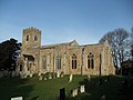 The Church of St Margaret, Clenchwarton - geograph.org.uk - 2738466.jpg 4,320 × 3,240; 5.36 MB
-
 The edge of a copse - geograph.org.uk - 1605567.jpg 640 × 480; 107 KB
-
 The Laurels, Terrington St Clement - geograph.org.uk - 501874.jpg 3,008 × 2,000; 4.26 MB
-
 The Lynn Channel leading out into The Wash - geograph.org.uk - 6124625.jpg 3,456 × 2,592; 3.66 MB
-
 The Main Road in Clenchwarton - geograph.org.uk - 3655198.jpg 2,664 × 2,064; 1.59 MB
-
 The Memorial Hall, Clenchwarton - geograph.org.uk - 4427597.jpg 1,024 × 768; 302 KB
-

-
 The sign of The Victory pub, Clenchwarton - geograph.org.uk - 4427585.jpg 768 × 1,024; 234 KB
-
 The Victory public house, Clenchwarton - geograph.org.uk - 4427584.jpg 1,024 × 768; 284 KB
-
 The War Memorial at Clenchwarton - geograph.org.uk - 4427575.jpg 768 × 1,024; 360 KB
-
 The West Lynn Drain looking inland - geograph.org.uk - 4427623.jpg 1,024 × 768; 459 KB
-
 To Kings Lynn 3 - geograph.org.uk - 2779999.jpg 1,024 × 768; 327 KB
-
 To Kings Lynn 4 - geograph.org.uk - 1186806.jpg 640 × 480; 88 KB
-

-
 Track off Ferry Road - geograph.org.uk - 4721116.jpg 640 × 480; 71 KB
-
 Track to Greenland north of Clenchwarton - geograph.org.uk - 1506024.jpg 640 × 480; 109 KB
-
 Tractor with equipment for preparing the ground for potatoes - geograph.org.uk - 6124300.jpg 3,456 × 2,592; 3.82 MB
-
 Tree along field drain - geograph.org.uk - 5145186.jpg 640 × 596; 53 KB
-
 Tree along field drain - geograph.org.uk - 5145188.jpg 640 × 426; 52 KB
-
 Trees and farmland off Black Horse Road, Clenchwarton - geograph.org.uk - 2199871.jpg 2,848 × 2,136; 3.03 MB
-
 Uncultivated field - geograph.org.uk - 4976839.jpg 1,024 × 768; 169 KB
-
 Victory Inn - geograph.org.uk - 5145181.jpg 640 × 354; 59 KB
-
 View across the River Great Ouse - geograph.org.uk - 3598308.jpg 4,000 × 3,000; 3.42 MB
-
 View across the River Great Ouse - geograph.org.uk - 3598374.jpg 2,680 × 2,132; 1.69 MB
-
 View alongside an old sea bank - geograph.org.uk - 4976907.jpg 1,024 × 768; 177 KB


_-_geograph.org.uk_-_4427600.jpg)


_-_geograph.org.uk_-_5537460.jpg)
_-_geograph.org.uk_-_5537458.jpg)


