Category:Clehonger
Jump to navigation
Jump to search
village in United Kingdom | |||||
| Upload media | |||||
| Instance of | |||||
|---|---|---|---|---|---|
| Location | Herefordshire, West Midlands, England | ||||
 | |||||
English: Clehonger is a village and civil parish in Herefordshire, England, south west of Hereford. The population of this civil parish at the 2011 census was 1,382.
Polski: Clehonger – wieś w Anglii, w hrabstwie Herefordshire. Leży 7 km na południowy zachód od miasta Hereford i 194 km na zachód od Londynu.

Subcategories
This category has the following 4 subcategories, out of 4 total.
Media in category "Clehonger"
The following 139 files are in this category, out of 139 total.
-

-
 3 miles to Hereford - geograph.org.uk - 3647364.jpg 800 × 652; 123 KB
-
 A Clehonger orchard - geograph.org.uk - 3645667.jpg 800 × 600; 151 KB
-
 A465 near Webtree - geograph.org.uk - 2954527.jpg 640 × 480; 36 KB
-
 A465 northbound - geograph.org.uk - 2954535.jpg 640 × 480; 37 KB
-
 A465 through Newton Coppice near Belmont - geograph.org.uk - 3648079.jpg 800 × 710; 161 KB
-
 Anglers packing-up for the day - geograph.org.uk - 908698.jpg 640 × 480; 90 KB
-
 Armorial Bearings of the AUBREY family of Clehonger, Herefordshire.png 1,200 × 1,200; 1,004 KB
-
 Armorial Bearings of the PROSSER family of Belmont, Clehonger, Herefordshire.png 1,200 × 1,200; 352 KB
-

-
 Armorial Bearings of the WHITMORE family of The Haywood, Clehonger, Herefordshire.png 1,200 × 1,200; 1.29 MB
-

-

-
 B4349 at Clehonger - geograph.org.uk - 908731.jpg 640 × 358; 67 KB
-
 Belmont Abbey (Altar) - geograph.org.uk - 5912100.jpg 3,648 × 2,736; 2.76 MB
-
 Belmont Abbey (Bell Tower) - geograph.org.uk - 5907544.jpg 3,648 × 2,736; 3.83 MB
-
 Belmont Abbey (Chancel) - geograph.org.uk - 5912104.jpg 3,648 × 2,736; 2.64 MB
-
 Belmont Abbey (Chancel) - geograph.org.uk - 5912113.jpg 3,648 × 2,736; 3.18 MB
-
 Belmont Abbey (Font) - geograph.org.uk - 5912799.jpg 3,648 × 2,736; 3.02 MB
-
 Belmont Abbey (Keyboard) - geograph.org.uk - 5912093.jpg 3,648 × 2,736; 2.56 MB
-
 Belmont Abbey (Lectern) - geograph.org.uk - 5912110.jpg 3,648 × 2,736; 3.41 MB
-
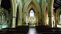
 Belmont Abbey (Nave) - geograph.org.uk - 5912116.jpg 3,648 × 2,736; 3.01 MB
-
 Belmont Abbey (North Aisle) - geograph.org.uk - 5912097.jpg 3,648 × 2,736; 3.14 MB
-
 Belmont Abbey (North Aisle) - geograph.org.uk - 5912802.jpg 3,648 × 2,736; 2.81 MB
-
 Belmont Abbey (North Transept) - geograph.org.uk - 5912115.jpg 3,648 × 2,736; 3.27 MB
-
 Belmont Abbey (Organ ^1) - geograph.org.uk - 5912092.jpg 3,648 × 2,736; 2.59 MB
-
 Belmont Abbey (Organ ^2) - geograph.org.uk - 5912821.jpg 3,648 × 2,736; 2.88 MB
-
 Belmont Abbey (South Aisle) - geograph.org.uk - 5911932.jpg 3,648 × 2,736; 2.46 MB
-
 Belmont Abbey (South Chapel) - geograph.org.uk - 5911887.jpg 3,648 × 2,736; 2.19 MB
-
 Belmont Abbey - geograph.org.uk - 5879743.jpg 3,648 × 2,736; 4.62 MB
-
 Belmont Abbey - geograph.org.uk - 5907539.jpg 3,648 × 2,736; 4.7 MB
-
 Belmont Abbey - geograph.org.uk - 5907540.jpg 3,648 × 2,736; 3.86 MB
-
 Belmont Abbey - geograph.org.uk - 5907542.jpg 3,648 × 2,736; 3.78 MB
-
 Belmont Abbey - geograph.org.uk - 5907551.jpg 3,648 × 2,736; 3.99 MB
-
 Belmont Abbey - geograph.org.uk - 5911851.jpg 3,648 × 2,736; 2.64 MB
-
 Belmont Abbey - geograph.org.uk - 5911854.jpg 4,096 × 3,072; 4.97 MB
-
 Belmont Abbey - geograph.org.uk - 5911951.jpg 3,648 × 2,736; 2.82 MB
-
 Belmont Abbey - geograph.org.uk - 5912763.jpg 1,920 × 1,080; 817 KB
-
 Belmont Abbey - geograph.org.uk - 5912828.jpg 3,648 × 2,736; 3.11 MB
-
 Belmont Abbey - geograph.org.uk - 5912855.jpg 3,648 × 2,736; 2.36 MB
-
 Belmont Abbey - geograph.org.uk - 5912946.jpg 1,920 × 1,080; 1.03 MB
-
 Belmont Abbey - geograph.org.uk - 5912950.jpg 3,648 × 2,736; 4.76 MB
-
 Belmont Village Hall - geograph.org.uk - 5905831.jpg 3,648 × 2,736; 4.76 MB
-
 Belmont Village Hall - geograph.org.uk - 5912958.jpg 3,648 × 2,736; 4.41 MB
-
 Belmont Village Hall - geograph.org.uk - 5912964.jpg 3,648 × 2,736; 4.73 MB
-
 Birch Hill Road, Clehonger - geograph.org.uk - 3646311.jpg 800 × 600; 87 KB
-
 Birch Meadow, Clehonger - geograph.org.uk - 3645695.jpg 800 × 670; 93 KB
-
 Bowley B^B, Clehonger - geograph.org.uk - 3645664.jpg 800 × 733; 109 KB
-
 Broomy Hill Water Tower (Hereford) - geograph.org.uk - 5912940.jpg 4,096 × 2,304; 2.53 MB
-
 Bulmers Angling Club notice, Clehonger - geograph.org.uk - 3647264.jpg 800 × 602; 113 KB
-
 Bus stop on the A465 at Belmont - geograph.org.uk - 2472803.jpg 640 × 480; 82 KB
-
 Cattle chiropodist, Clehonger - geograph.org.uk - 3645659.jpg 800 × 573; 99 KB
-

-
 Ceiling at Belmont Abbey (Chancel) - geograph.org.uk - 5912109.jpg 3,648 × 2,736; 3 MB
-
 Ceiling at Belmont Abbey (Chancel) - geograph.org.uk - 5912112.jpg 3,648 × 2,736; 2.99 MB
-
 Ceiling at Belmont Abbey (South Chapel) - geograph.org.uk - 5911922.jpg 3,648 × 2,736; 1.54 MB
-
 Chair at Belmont Abbey (Chancel) - geograph.org.uk - 5912111.jpg 3,648 × 2,736; 2.87 MB
-
 Church Road Clehonger - geograph.org.uk - 3647225.jpg 800 × 733; 130 KB
-
 Clock on Belmont Abbey (Bell Tower) - geograph.org.uk - 5907579.jpg 3,648 × 2,736; 4.56 MB
-

-
 Crossway Farm, Clehonger - geograph.org.uk - 149730.jpg 640 × 426; 118 KB
-
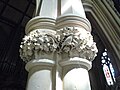 Detail of Belmont Abbey (Pillar ^ Chancel) - geograph.org.uk - 5912106.jpg 3,648 × 2,736; 2.73 MB
-
 Distances from Clehonger - geograph.org.uk - 3645690.jpg 800 × 676; 98 KB
-
 Dove on Belmont Abbey - geograph.org.uk - 5912912.jpg 4,096 × 2,730; 4.45 MB
-
 Eastern boundary of Clehonger - geograph.org.uk - 3647313.jpg 800 × 800; 170 KB
-
 Eastern end of the B4349 near Belmont - geograph.org.uk - 3647338.jpg 800 × 768; 101 KB
-

-
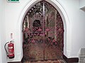
 Entrance to Belmont Abbey - geograph.org.uk - 5912863.jpg 3,648 × 2,736; 3 MB
-
 Entrance to Belmont Abbey - geograph.org.uk - 5912866.jpg 3,648 × 2,736; 2.5 MB
-

-

-

-
 Farmland near Old Clehonger - geograph.org.uk - 3724673.jpg 2,592 × 1,944; 1.23 MB
-
 Field next to the B4349 - geograph.org.uk - 2471454.jpg 640 × 480; 91 KB
-
 Fishing pond - geograph.org.uk - 908700.jpg 640 × 480; 85 KB
-
 Fishing pool, Bulmers Angling Club - geograph.org.uk - 888352.jpg 640 × 458; 152 KB
-
 Footpath to Clehonger - geograph.org.uk - 3273851.jpg 1,024 × 680; 255 KB
-
 Footpath to Clehonger Court - geograph.org.uk - 908687.jpg 640 × 480; 75 KB
-
 Footpath to Hunderton - geograph.org.uk - 888355.jpg 480 × 640; 194 KB
-

-
 Golf club car park - geograph.org.uk - 2471411.jpg 640 × 480; 60 KB
-
 Hereford Cathedral (Viewed from Belmont Abbey) - geograph.org.uk - 5912896.jpg 3,648 × 2,736; 3.18 MB
-

-

-

-
 Kissing gate to footpath by fishing pool - geograph.org.uk - 888356.jpg 640 × 480; 159 KB
-

-
 Lane heading towards Belmont - geograph.org.uk - 2471440.jpg 640 × 480; 65 KB
-
 Lane joining the B4349 and the A465 - geograph.org.uk - 2471462.jpg 640 × 480; 74 KB
-

-

-
 Memorial inside Belmont Abbey (North Transept) - geograph.org.uk - 5912095.jpg 3,648 × 2,736; 1.86 MB
-
 Minor road to Ruckhall - geograph.org.uk - 4434965.jpg 1,024 × 768; 273 KB
-

-
 Old Milepost by the B4349, (geograph 6045486).jpg 1,232 × 1,704; 419 KB
-

-
 Old Milestone, B4349, near Bowley Farm, Clehonger (geograph 6044166).jpg 1,301 × 1,704; 465 KB
-
 Ordnance Survey Cut Mark - geograph.org.uk - 6127689.jpg 1,024 × 714; 181 KB
-
 Ordnance Survey Cut Mark - geograph.org.uk - 6127695.jpg 1,024 × 678; 288 KB
-
 Parallel roads - geograph.org.uk - 908723.jpg 640 × 397; 84 KB
-
 Parish Hall, Belmont - geograph.org.uk - 3648267.jpg 800 × 600; 98 KB
-
 Perryhill Farm - geograph.org.uk - 919805.jpg 640 × 295; 46 KB
-

-
 Potato crop - geograph.org.uk - 905266.jpg 640 × 480; 111 KB
-
 River Wye, Breinton Springs - geograph.org.uk - 2535516.jpg 1,280 × 856; 285 KB
-
 Road to Clehonger - geograph.org.uk - 2471433.jpg 640 × 480; 97 KB
-
 Road to Perryhill Farm - geograph.org.uk - 919806.jpg 640 × 480; 102 KB
-
 Ruckhall Lane, Belmont - geograph.org.uk - 3648090.jpg 800 × 800; 170 KB
-
 Ruckhall Lane, Belmont - geograph.org.uk - 3648131.jpg 800 × 761; 123 KB
-
 Ruckhall Mill and cottages - geograph.org.uk - 919804.jpg 640 × 387; 77 KB
-
 Ruckhall Wood - geograph.org.uk - 3103421.jpg 1,024 × 680; 257 KB
-
 Sign at Belmont Abbey - geograph.org.uk - 5907587.jpg 3,648 × 2,736; 3.56 MB
-
 Statue at Belmont Abbey - geograph.org.uk - 5907547.jpg 3,648 × 2,736; 4.38 MB
-
 Statue of Jesus Christ at Belmont Abbey (South Aisle) - geograph.org.uk - 5912758.jpg 3,648 × 2,736; 2.76 MB
-
 The B4349 passing through Clehonger - geograph.org.uk - 149725.jpg 640 × 426; 105 KB
-
 The City of Hereford - geograph.org.uk - 5912935.jpg 4,096 × 1,780; 2.18 MB
-
 The fishing pool at Old Clehonger - geograph.org.uk - 3724670.jpg 2,592 × 1,944; 1.14 MB
-
 The Old Vicarage Guest House, Clehonger - geograph.org.uk - 3647230.jpg 800 × 596; 107 KB
-
 The Seven Stars near Clehonger - geograph.org.uk - 3646392.jpg 800 × 600; 86 KB
-
 The Village of Belmont - geograph.org.uk - 5905864.jpg 3,648 × 2,736; 4.84 MB
-
 Track to Dunan - geograph.org.uk - 905272.jpg 640 × 350; 67 KB
-
 View across a barley field - geograph.org.uk - 888342.jpg 640 × 461; 159 KB
-
 View across Belmont Park - geograph.org.uk - 919814.jpg 640 × 310; 46 KB
-
 Village Hall, Clehonger - geograph.org.uk - 3646349.jpg 800 × 539; 94 KB
-
 Village housing, Clehonger - geograph.org.uk - 908727.jpg 640 × 440; 60 KB
-
 Water pump near the Cage Brook - geograph.org.uk - 5804040.jpg 2,736 × 3,648; 3.17 MB
-
 Western boundary of Clehonger - geograph.org.uk - 3643446.jpg 800 × 722; 165 KB
-
 Wheat field with shower approaching - geograph.org.uk - 888350.jpg 640 × 480; 147 KB
-
 Wheatfield, Clehonger - geograph.org.uk - 888346.jpg 640 × 480; 140 KB
-
 Window inside Belmont Abbey (Chancel) - geograph.org.uk - 5911952.jpg 2,048 × 3,072; 3.12 MB
-
 Window inside Belmont Abbey (Nave) - geograph.org.uk - 5912711.jpg 2,048 × 3,072; 2.47 MB
-
 Window inside Belmont Abbey (North Aisle) - geograph.org.uk - 5912098.jpg 2,048 × 3,072; 2.77 MB
-
 Window inside Belmont Abbey (North Aisle) - geograph.org.uk - 5912817.jpg 2,048 × 5,120; 3.3 MB
-
 Window inside Belmont Abbey (South Aisle) - geograph.org.uk - 5911943.jpg 2,048 × 4,096; 3.57 MB
-
 Window inside Belmont Abbey (South Aisle) - geograph.org.uk - 5912117.jpg 2,048 × 3,072; 2.92 MB
-
 Window inside Belmont Abbey (South Chapel) - geograph.org.uk - 5911895.jpg 2,048 × 2,730; 2.56 MB
-
 Window inside Belmont Abbey (South Chapel) - geograph.org.uk - 5911898.jpg 4,096 × 3,072; 4.42 MB
-
 Wye Valley NHS Trust, Belmont - geograph.org.uk - 3648154.jpg 800 × 600; 120 KB
-
 Fishing Pool, Clehonger - geograph.org.uk - 149720.jpg 640 × 426; 126 KB


_-_geograph.org.uk_-_5912100.jpg)
_-_geograph.org.uk_-_5907544.jpg)
_-_geograph.org.uk_-_5912104.jpg)
_-_geograph.org.uk_-_5912113.jpg)
_-_geograph.org.uk_-_5912799.jpg)
_-_geograph.org.uk_-_5912093.jpg)
_-_geograph.org.uk_-_5912110.jpg)
_-_geograph.org.uk_-_5912116.jpg)
_-_geograph.org.uk_-_5912097.jpg)
_-_geograph.org.uk_-_5912802.jpg)
_-_geograph.org.uk_-_5912092.jpg)
_-_geograph.org.uk_-_5912821.jpg)
_-_geograph.org.uk_-_5911932.jpg)
_-_geograph.org.uk_-_5911887.jpg)


_-_geograph.org.uk_-_5912940.jpg)


_-_geograph.org.uk_-_5912109.jpg)
_-_geograph.org.uk_-_5912112.jpg)
_-_geograph.org.uk_-_5911922.jpg)
_-_geograph.org.uk_-_5912111.jpg)

_-_geograph.org.uk_-_5907579.jpg)


_-_geograph.org.uk_-_5912106.jpg)


_-_geograph.org.uk_-_5912896.jpg)


.jpg)
.jpg)
.jpg)


_-_geograph.org.uk_-_5912758.jpg)


_-_geograph.org.uk_-_5911952.jpg)
_-_geograph.org.uk_-_5912711.jpg)
_-_geograph.org.uk_-_5912098.jpg)
_-_geograph.org.uk_-_5911943.jpg)
_-_geograph.org.uk_-_5912117.jpg)
_-_geograph.org.uk_-_5911895.jpg)
_-_geograph.org.uk_-_5911898.jpg)


_-_geograph.org.uk_-_5912115.jpg)
_-_geograph.org.uk_-_5912095.jpg)
_-_geograph.org.uk_-_5912817.jpg)