Category:Chute Sainte-Anne (Parc national de la Gaspésie)
Jump to navigation
Jump to search
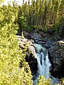
Français : Chute Sainte-Anne à proximité du Gîte du Mont-Albert, 2001, route du Parc, route 299, Mont-Albert, Québec
| Object location | | View all coordinates using: OpenStreetMap |
|---|
Media in category "Chute Sainte-Anne (Parc national de la Gaspésie)"
The following 16 files are in this category, out of 16 total.
-
 Chute Sainte-Anne - 01.jpg 3,456 × 4,608; 5.11 MB
-
 Chute Sainte-Anne - 02.jpg 4,608 × 3,456; 5.05 MB
-
 Chute Sainte-Anne - 03.jpg 3,456 × 4,608; 5.82 MB
-
 Chute été 2021.jpg 3,024 × 4,032; 2.8 MB
-
 Parc national de la Gaspésie - chute Sainte-Anne - 1.jpg 6,000 × 4,000; 6.57 MB
-
 Parc national de la Gaspésie - chute Sainte-Anne - 2.jpg 6,000 × 4,000; 6.68 MB
-
 Parc national de la Gaspésie - chute Sainte-Anne - 3.jpg 4,000 × 6,000; 6.75 MB
-
 Parc national de la Gaspésie - chute Sainte-Anne - 4.jpg 4,000 × 6,000; 6.97 MB
-
 Parc national de la Gaspésie - chute Sainte-Anne - 5.jpg 4,000 × 6,000; 7.16 MB
-
 Sainte Anne waterfall PN de la Gaspesie 1.jpg 2,736 × 3,648; 5.31 MB
-
 Sainte Anne waterfall PN de la Gaspesie 2.jpg 2,736 × 3,648; 5.87 MB
-
 Sainte Anne waterfall PN de la Gaspesie 3.jpg 2,736 × 3,648; 6.88 MB
-
 Sainte Anne waterfall PN de la Gaspesie 4.jpg 3,986 × 5,979; 16.08 MB
-
 Sentier vers la chute Sainte-Anne - 01.jpg 4,409 × 3,307; 6.66 MB
-
 Sentier vers la chute Sainte-Anne - 02.jpg 3,456 × 4,608; 7.4 MB
-
 Sentier vers la chute Sainte-Anne - 03.jpg 4,608 × 3,456; 6.74 MB


