Category:Church of the Most Holy Trinity, Ballybricken
Jump to navigation
Jump to search
| Object location | | View all coordinates using: OpenStreetMap |
|---|

|
This object is indexed in the National Inventory of Architectural Heritage of Ireland under the registration number 22502069
Geographic information system of the National Monuments Service: Historic Environment Viewer – Main record. |
Media in category "Church of the Most Holy Trinity, Ballybricken"
The following 46 files are in this category, out of 46 total.
-

-
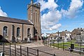 Ballybricken Church of the Holy Trinity Without, Waterford -155288 (48654864217).jpg 7,952 × 5,304; 23.2 MB
-
 Ballybricken graveyard of the Church of the Holy Trinity Without -155284 (48654362798).jpg 5,304 × 7,952; 23.34 MB
-
 Ballybricken graveyard of the Church of the Holy Trinity Without -155285 (48654720111).jpg 5,304 × 7,952; 19.49 MB
-

-

-
-

-

-
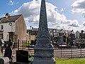
 Captain Clooney Memorial in Ballybricken -155254 (48649779817).jpg 7,952 × 5,304; 22.1 MB
-
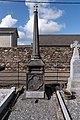
 Captain Clooney Memorial in Ballybricken, Waterford -155249 (48649635091).jpg 7,952 × 5,304; 30.19 MB
-
 Captain Patrick Clooney Memorial in Ballybricken -155255 (48649275558).jpg 7,952 × 5,304; 18.3 MB
-
 Captain Patrick Clooney Memorial in Ballybricken, Waterford -155250 (48649775742).jpg 7,952 × 5,304; 31.91 MB
-
 Captain Patrick Clooney Memorial in Ballybricken, Waterford -155251 (48649273133).jpg 7,952 × 5,304; 32.3 MB
-
 Captain Patrick Clooney Memorial in Ballybricken, Waterford -155253 (48649276853).jpg 7,952 × 5,304; 37.41 MB
-
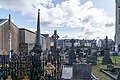
 Church of the Most Holy Trinity Without, Ballybricken, cemetery -155278 (48654689851).jpg 7,952 × 5,304; 28.36 MB
-
 Church of the Most Holy Trinity Without, Ballybricken, cemetery -155279 (48654331133).jpg 7,952 × 5,304; 26.81 MB
-
 Church of the Most Holy Trinity Without, Ballybricken, cemetery -155280 (48654687746).jpg 7,952 × 5,304; 26.43 MB
-
 Clooney Memorial -155252 (48649637971).jpg 6,856 × 5,158; 18.04 MB
-
 Clooney Memorial in Ballybricken -155257 (48649274348).jpg 5,304 × 7,952; 22.78 MB
-
 Graveyard of the Church of the Holy Trinity Without, Ballybricken -155283 (48654721936).jpg 7,952 × 5,304; 20.03 MB
-

-

-

-

-

-

-

-

-

-

-

-

-

-

-
 Holy Trinity Without, Ballybricken, churchyard -155281 (48654690766).jpg 7,952 × 5,304; 26.47 MB
-
 Holy Trinity Without, Ballybricken, churchyard -155306 (48654341823).jpg 7,952 × 5,304; 26.76 MB
-
 Holy Trinity Without, Ballybricken, churchyard -155307 (48654340678).jpg 7,952 × 5,304; 24.04 MB
-
 Holy Trinity Without, Ballybricken, churchyard -155308 (48654845167).jpg 7,952 × 5,304; 21.52 MB
-
 Holy Trinity Without, Ballybricken, churchyard -155309 (48654696641).jpg 7,952 × 5,304; 23.27 MB
-
 Holy Trinity Without, Ballybricken, churchyard -155310 (48654337763).jpg 7,952 × 5,304; 20.4 MB
-
 Holy Trinity Without, Ballybricken, churchyard -155311 (48654842857).jpg 7,952 × 5,304; 20.58 MB
-
 Holy Trinity Without, Ballybricken, churchyard -155312 (48654694391).jpg 7,952 × 5,304; 26.73 MB
-
 Holy Trinity Without, Ballybricken, churchyard -155313 (48654335863).jpg 7,952 × 5,304; 22.77 MB
-
 Holy Trinity Without, Ballybricken, churchyard -155315 (48654839442).jpg 7,952 × 5,304; 21.02 MB
-
 Holy Trinity Without, Ballybricken, Waterford -155293 (48654712411).jpg 7,952 × 5,304; 19.09 MB
.jpg)
.jpg)
.jpg)
.jpg)
.jpg)
.jpg)
.jpg)
.jpg)
.jpg)
.jpg)
.jpg)
.jpg)
.jpg)
.jpg)
.jpg)
.jpg)
.jpg)
.jpg)
.jpg)
.jpg)
.jpg)
.jpg)
.jpg)
.jpg)
.jpg)
.jpg)
.jpg)
.jpg)
.jpg)
.jpg)
.jpg)
.jpg)
.jpg)
.jpg)
.jpg)
.jpg)
.jpg)
.jpg)
.jpg)
.jpg)
.jpg)
.jpg)
.jpg)
.jpg)
.jpg)
.jpg)