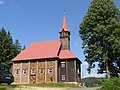
Category:Church of Saint Mary of Help (Gruň)
Jump to navigation
Jump to search
| Object location | | View all coordinates using: OpenStreetMap |
|---|
|
This is a category about a cultural monument of the Czech Republic,
number: 52103/8-4080. |
Čeština: Kaple Panny Marie na Gruni
church in Frýdek-Místek District of Moravian Silesian region  | |||||
| Upload media | |||||
| Instance of | |||||
|---|---|---|---|---|---|
| Patron saint | |||||
| Location |
| ||||
| Diocese | |||||
| Heritage designation | |||||
| Religion or worldview | |||||
 | |||||
Subcategories
This category has only the following subcategory.
Media in category "Church of Saint Mary of Help (Gruň)"
The following 7 files are in this category, out of 7 total.
-
 739 15 Staré Hamry, Czech Republic - panoramio (3).jpg 3,888 × 2,592; 1.52 MB
-
 Dřevěný kostel na Gruni - detail.jpg 1,600 × 1,200; 616 KB
-
 Dřevěný kostel Panny Marie na Gruni.jpg 1,572 × 1,187; 866 KB
-
 Gruň - Kaple Panny Marie Pomocné.jpg 3,175 × 2,217; 11.05 MB
-
 Grúň, Kostel Panny Marie Pomocné, západ.jpg 3,072 × 2,304; 1.46 MB
-
 Kaple Panny Marie na Gruni, noční.jpg 2,200 × 1,467; 1.16 MB
-
 Staré Hamry, Kaple Panny Marie na Gruni, noční.jpg 2,200 × 1,471; 1.17 MB
.jpg)


