Category:Church of Gunzgen
Jump to navigation
Jump to search
| Object location | | View all coordinates using: OpenStreetMap |
|---|
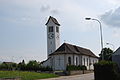
church building in Gunzgen in the canton of Solothurn, Switzerland   | |||||
| Upload media | |||||
| Instance of | |||||
|---|---|---|---|---|---|
| Part of | |||||
| Location | Gunzgen, Olten District, Olten-Gösgen, Solothurn, Switzerland | ||||
| Street address |
| ||||
| Diocese | |||||
| Heritage designation | |||||
 | |||||
Media in category "Church of Gunzgen"
The following 5 files are in this category, out of 5 total.
-
 Gunzgen preghejo 133.JPG 3,872 × 2,592; 2.58 MB
-
 Gunzgen preghejo 136.JPG 2,592 × 3,872; 3.01 MB
-
 Gunzgen preghejo 137.JPG 3,872 × 2,592; 3.38 MB
-
 Gunzgen preghejo 138.JPG 3,872 × 2,592; 3.39 MB
-
 Gunzgen preghejo orgene 139.JPG 3,872 × 2,592; 3.32 MB


