Category:Church Rock uranium mill
Jump to navigation
Jump to search
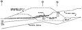
English: The Church Rock Uranium Mill spill — when the United Nuclear Corporation's uranium mill tailings disposal pond broke through its dam, in July 1979 in New Mexico.
- Over 1,000 tons of solid radioactive mill waste and 93 million gallons of acidic, radioactive tailings solution flowed into the Puerco River, from McKinley County, New Mexico to Navajo County, Arizona and onto the Navajo Nation.
- The former uranium facility and current Superfund site is located 17 miles (27 km) north of Gallup, New Mexico.
spill in New Mexico on July 16, 1979 | |||||
| Upload media | |||||
| Instance of | |||||
|---|---|---|---|---|---|
| Location | New Mexico | ||||
| Point in time |
| ||||
 | |||||
Media in category "Church Rock uranium mill"
The following 14 files are in this category, out of 14 total.
-
 Church Rock uranium mill cleanup.jpeg 500 × 338; 24 KB
-
 Church Rock uranium mill EID sign.jpeg 500 × 338; 32 KB
-
 Church Rock uranium mill tailings dam breach.jpeg 500 × 338; 39 KB
-
 Church Rock, New Mexico soil removal.png 1,031 × 554; 726 KB
-
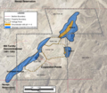 Extent of Seepage-Impacted Groundwater 2009 Church Rock uranium mill edited.png 1,572 × 1,370; 2.44 MB
-
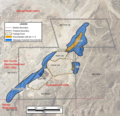 Extent of Seepage-Impacted Groundwater 2009 Church Rock uranium mill.png 1,572 × 1,515; 2.7 MB
-
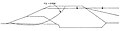
 Church Rock tailings dam breach diagram.jpg 1,830 × 850; 307 KB
-
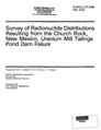 Survey of Radionuclide Distributions Resulting from the Church Rock, New Mexico, Uranium Mill Tailings Pond Dam Failure OCR.pdf 1,264 × 1,643, 168 pages; 41.04 MB
-
 The Failure of the Church Rock Tailings Dam 01.JPG 1,209 × 316; 34 KB
-
 The Failure of the Church Rock Tailings Dam 02.JPG 1,198 × 444; 64 KB
-
 The Failure of the Church Rock Tailings Dam.pdf 900 × 1,262, 5 pages; 2.67 MB
-
 United Nuclear Corporation Church Rock Uranium Mill.jpeg 600 × 399; 82 KB
-
 United Nuclear Corporation EPA Church Rock map.jpg 493 × 295; 55 KB
-
 United Nuclear Corporation Site McKinley County New Mexico.jpg 456 × 354; 83 KB


